| Trail |
    (2.68)15
|
    (1.69) |
|
| 13.00 Miles |
62 Feet |
| N/A |
|
| No |
Yes |
| $2.00
|
More Info
|
| Somerville |
Burleson |
|
Take Action
|
 |
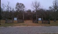
| The start of the trail at Nails Creek features this impressive gate. |
Lake Somerville is one of those Texas State Parks that is broken up into two units, each taking up part of a peninsula on either side of a man-made lake. These two units are not entirely disconnected though since they share termini of a 13 mile trail that runs between them on the western side of the lake.
The trail is wide and easy to follow. A jeep or truck can easily navigate the path and that's probably how the park maintains the facilities along the trail's route.
 |
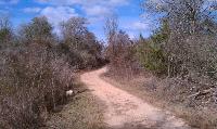
| The trail surface is mostly jeep trail, so it's wide and easy to follow. |
Since the trail mostly follows the edge of a lake common sense would indicate that this means there would be little elevation gain through its length and this turns out to be the case. Where the trails follows small ridges overlooking the the flats on which the lake lies there's a little bit of up and down. However, this is an easy enough hike for hikers or any age.
Horses are allowed on the trail, so if you are nervous around them you might want to look elsewhere. Horse manure, or lack thereof, indicates that riders don't make use of this trail as much as they do others, such as McKinney Roughs.
The waypoint marked "Bird Blind" at the northwestern edge of Flag Pond is an excellent place to stop for lunch. It's off the beaten path and there are plenty of picnic tables on which to eat. In the spring you might also be able to spot a few birds. Strangely, though the covered shelter here looks relatively new the surrounding vegetation looks like it's already moving in for the kill.
 |
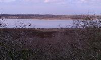
| Lake Somerville with a flock of birds in the distance. |
Private land and homes often come very close to the trail where it skirts along the edges of park and preserve boundary. This is most apparent when the trail hugs the southern boundary of Flag Pond. Numerous homes and fishing or hunting camps line the shore just on the other side of boundary fence. It's easy to see why they'd choose to build here since it represents some of the nicest views along the trail.
Unless you are anxious to hike every inch of the trail I'd recommend avoiding the Flag Pond Look Trail segment along Flag Pond's northern shore. It's little more than an earthen berm rising above the flats on either side of it. There is little in terms of nice views of the lake since the brush is higher here. The southern pond shore along the main trail is much more scenic.
Yegua Creek marks the halfway point between the Nails Creek and Birch Creek units of the binary park pair. There's a parking area here along with a self pay station.
Some hikers have pointed out that there's very little here in terms of scenic views and certainly there's some truth in that viewpoint. The flat terrain does not lend itself to sweeping vistas. The dry conditions and lower water levels are probably not helping to draw more birds to the area. If there were more avian visitors that would be a big draw for many.
Patches of solitude
User:
Austin Explorer -
1/26/2013
[View Log Page]
Rating: 


Difficulty: 


Distance: 12.85 Miles
Duration: 5 hours, 17 minutes
I encountered very few people in the middle of this hike. Near the trailhead and turnaround point (about halfway between the Birch Creek and Nails Creek Units) there were a lot more people, but the trail is long enough in between to really filter out the less adventerous.
Though horses are allowed on the trail it looks like it gets far less equine traffic than McKinney Roughs. There's less stuff to keep an eye out on, but it still pays to pay attention.
The fishing along Yegua Creek at my turnaround point must be really good. I was quite shocked at the number of cars parked there, all of which seemed to have people with rods and reels coming and going.
The views on the trail are not great, but there's a good deal of mileage here and the elevation changes are not too tough. I wouldn't drive across Texas to hike this one, but I don't like THAT far away and I'm a sucker for wanting to map the remainder of the trail, so I'll be back.
Loop Flag Pond from Nails Creek Unit
User:
kcameron -
6/28/2008
[View Log Page]
Rating: 


Difficulty: 


Distance: 8.00 Miles
Duration: 4 minutes
I've heard of this trail for quite a while, so I'm glad I finally got around to hiking it. Having said that, though, I doubt I'll return. I just didn't find the trail to be scenic. I understand, though, that the spring wildflower display is impressive. If I were to hike it again, I would do so at that time.
The hike itself wasn't really bad. The wife and I had the trail to ourselves. We did not meet a single person the entire hike. However, about a quarter mile or so from the trailhead, we heard a loud humming, which turned out to be a well head pumping. The trail passes right next to it, and you can hear it for at least a quarter of the mile at the spot where you get your first glimpse of the lake. Later, somewhere along the west route around Flag Pond, we heard more oil well activity.
I was glad much of the trail we hiked was in the shade, as the day was hot. Two old foggies in their mid to late fifties really shouldn't be wandering around the Texas countryside in late June during the middle of the day. Also, much of the first 2 miles of the trail is very sandy, which makes walking difficult.
We looped the Flag Pond clockwise. I was surprised to find some cabins overlooking the pond (just outside the park fenceline), but I was disappointed the pond and much of the lake were covered by lily pads and other growth. The pond had very little water. If you do hike this way, be sure to stop at the wildlife viewing area near the northwest section of the pond. It is a good rest spot; however, there wasn't much wildlife to view.
We spotted one deer at the north end of Flag Pond and one armadillo early in the hike. The east side of Flag Pond is almost completely exposed to the sun, though the walking is easy on a roadbed. Most of the hike is fairly level with occasional inclines the first 2 miles from the Nails Creek trailhead.
My recommendation would be to save this trail for spring time when the wildflowers are in bloom.
Trailway From Birch Creek Unit
User:
Lone_Star -
2/14/2008
[View Log Page]
Rating: 


Difficulty: 


Distance: 17.00 Miles
Duration: 6 hours
I parked at the Ranger Station HQ and took the Trailway out towards Yegua Creek. I had hiked the other half (Nails Creek Trailway) about a week ago and I wanted to complete the rest of the hike.
Like the Nails Creek Trailway, the trail is a wide service road more than a nature trail. There are rest stops every few miles with a map showing your current location. There's not a lot to see. At the beginning of the hike, you are within sight of Lake Somerville and you can take a loop to approach even closer. As I did, I ran into a large family of wild boars. There must have been close to 10 of them.
Along the way, you will see some oil pumps and storage tanks, but it's really just a lot of shrubs and trees most of the way. Occassionally, you will see some white tailed deer and some nice redbirds or large cranes.
Aside from a few loops, there is really only one long trail to Yegua Creek. When I got there, I saw several people fishing. The fish must have been biting pretty good because I saw a few guys carrying about 5 fish each that were fairly large.
The one complaint I have about this State Park Trailway is that the trail is not well marked in the Yegua Creek / Newman's Bottom area. It is fairly well marked by posts the rest of the trail, but in this area you can easily miss a turn in the trail and go off on a service road that looks just like the trail you've been walking on. This happened to me last week, adding about 2 miles to my hike, and it happened to me again today. The trail turns and runs along Yegua Creek (and the trailway map shows this), but the physical markers aren't very visible and easy to miss. This could easily be resolved by posting one or two signs (with words) in the Yegua Creek area to help prevent people from getting off course.
On my way back, I ran into a 4 foot snake on the trail. It was directly in my path (laying across the trail), but I carefully managed to go around him.
At dusk, a lot of deer will come out to graze in the grassy areas near the Park HQ. They are very friendly and generally not scared of people at all.
Nails Creek Main Trail
User:
Lone_Star -
2/8/2008
[View Log Page]
Rating: 


Difficulty: 


Distance: 13.60 Miles
Duration: 4 hours, 30 minutes
I parked at the Pavilion and took the Main Somerville Trailway (including a small loop via Nails Creek Trail).
The trail was mostly a wide service road and a bit rocky at times. There were a few rolling hills, but nothing very difficult.
I opted to take the Flag Lake Loop Trail around to where it rejoins the main trail. There were a lot of ducks and birds on the pond.
I took the Main Trail as it zig zagged to the small bridge at Yegua Creek. There was a guy fishing there at the creek. He had caught a fish that was about 10 inches long.
On my way back to Flag Pond, I decided to take the west route, but I got off course here because the map wasn't very accurate in portraying the service roads vs the trail. As a result, I walked out of the park, past a gas facility and onto some rancher's land before I realized I was off course. The park could do a better job here by posting better directional signs towards the trail as well as when you are leaving the park boundaries.
Once I got back on the right trail, which incidentally is right along the lake shore, everything went fine. The trails were in very good condition overall. I saw a few deer and some wild boars on this hike, but they were scared an quickly ran off to avoid me.
This trail is also frequented by equestrians, although I did not see any on this weekday.
A nice, long, flat hike, with some people
User:
Ezmate -
11/18/2005
[View Log Page]
Rating: 


Difficulty: 


Distance: 28.00 Miles
Duration: N/A
My wife, my dog & I started from the Nails Creek Unit & hiked to Newman's Bottom campsite (6 miles). The next day, we hiked to the Birch Creek Unit & back to the Flag Pond campsite (17 miles). The final day, we hiked 5 miles back to our car at Nails Creek.
**********
On Friday, we only saw two people: a pair of women riding hoseback. On Saturday, the trail had 6 bikeriders, 1 jogger & 4 horse riders. Of course, right as we were heading back to Newman's Bottom, we saw an entire troop of boyscouts heading to the sam site, so we detoured over to Flag Pond. Sunday, we got up early & didn't see a single person as we hiked out.
**********
The trail system at Somerville is a mixture of service roads and very wide foot trails. There was no potable water out on the trail & the lake is a pain to get to (very muddy banks), but we filtered water from the livestock wells.
**********
Newman's Bottom was a heavily wooded area consisting of 3 separate campsites with trees & shrubs completely surrounding you. The ground was relatively soft sand & was pretty dry.
**********
Flag Pond was a much more open camping area and could easily serve as a group campsite for 10 people. It was very open to the sky, allowing us to track the full moon throughout the night.
**********
Also, we backpacked during duck-hunting season, so each morning, we awoke to the sounds of distant gun shots.
**********
Finally, we saw a lot of animals: lots of javelinas & deer, hawks, ducks, geese, & many other large birds. At night we heard a pack of coyotes & a few very loud owls.