Country Club Creek Trail

Trail
2.40 Miles
150 Feet
Free
2point5stars (2.93)10
1star (1.00)
2point5stars (2.80)
N/A
Yes
Yes
No
Austin
Travis
More Info

The wide trail and open spaces all around provide for lots of Sun.
Getting there: From I-35 near central Austin, take the Riverside Drive exit and head east. Turn left on Pleasant Valley Road and head north. Turn right into the Krieg Field Softball Complex, immediately after the Austin Fire Department training tower. Keep to the right and continue all the way to the back of the parking area.

The Hike: The City of Austin has big plans for Guerrero Park. This 363 acre park is comparable to Zilker in size and the city of Austin hopes to match it in features, providing top notch recreational opportunities for the east side of the city.

This small creek parallels the trail for some distance before discharging into the river.
Besides the Krieg and Montopolis playing fields on either side of the park, the land is still largely untouched. One of the newest additions is the hike and bike path that was added as an extension of the Town Lake trail system. We began our hike at the waypoint "Trailhead".

The trail parallels the parking area and a small creek to the right before making a turn onto a gully crossing constructed of concrete. The amount of trash that collects here is very disappointing, but don't let it disturb your overall enjoyment of the day. Compared to the washed down trash found here, the rest of the park was largely litter free. Bring along a trash bag and help collect some of the rubbish on your way out.

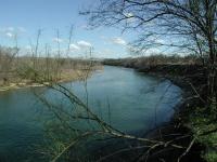
There is only spot along the trail that provides a good look at the river.
The path surface is crushed gravel and the trail is mostly flat and largely straight. Sure the path curves a bit to the right as you head east, but for large portions of the hike the path before you appears straight as an arrow. There are plenty of trees, but they do not tower over the trail, so there is plenty of direct sunlight for most of the hike.

At the creek crossing near the trailhead there's some shade, but that won't last long.
The land here is undeveloped, but hardly untouched. One of the most common trees seen near the trail was the Chinaberry, an introduced species that crowds out native varieties. In some parks the city attempts to curtail these and other invasive species to return the balance towards native plants. We're uncertain if that is in this park's plan.

At the waypoint "Overlook" the trees give way to a slight opening that provides some views of the Colorado River. Be careful not to venture too close to the edge of the bluff overlooking the river since it is largely made up of dirt here and could give way.

The trail ends at the Montopolis Sports Complex on the eastern side of the park. We hiked the trail on an absolutely beautiful, sunny Sunday afternoon. So we found it a bit odd that this complex of ball fields was completely empty and locked up. Perhaps these fields are only used for league games.

The trail ends at the sports complex, so we retraced our steps back to the trailhead. In an hour and a half of hiking we only saw a handful of people even with the spectacular weather. Though not a challenging experience the trail's relative solitude makes it an attractive alternative to the often busy Town Lake trail.

Photos
River view
Fishing dude crossing a shallow area at low water. (Photo by Mr Avocado)
River beach
Low water ~ 85 cfs (Photo by Mr Avocado)
Wash
is usually dry. (Photo by Mr Avocado)
The wash
... is fun to explore. (Photo by Mr Avocado)
Trail View
An extension of the popular Town Lake Hike and Bike Trail, the park sees relatively few visitors. (Photo by Austin Explorer)
Last Look
Look, people! (Photo by Austin Explorer)
Log Entries
Great jogging trail
By kjv1212 on 4/5/2014
Rating: 4stars Difficulty: 1star Solitude: 2stars
Distance: 1.00 Mile Duration: N/A

One of my favorite spots on the Butler trail to jog.

Good off trail hiking, wading, and birds
By Mr Avocado on 11/17/2012
Rating: 4stars Difficulty: 2stars Solitude: 3stars
Distance: 2.00 Miles Duration: N/A
The sandy wash is interesting to explore, and it ends at a nice beach on the river. Wading and crossing the river is also good. But, this is an "inner city" park with traffic noise and other urban problems. Update - River Park makes the Chronicle Best of Austin: Best Eastside Outdoor Fix: Roy G. Guerrero Colorado River Park. This hidden treasure, full of potential, has been overlooked for too long. There is a back entrance with trails that practically connect to the tail end of the Ladybird Lake trail. The city has just completed a renovation of the woods into an expansive and shady disc golf course. And we are now publicly outing the real treasure of the park, Secret Beach, which has been overrun in recent summers, anyway. This sandy banked bend of the river below the dam is perfect for doing what Austinites do best, hanging out and swimming. 400 Grove, 974-6700 www.austinparks.org/apfweb/park.php?parkId=325
Bleh
By texaskdog on 1/9/2010
Rating: 2stars Difficulty: 1star Solitude: 3stars
Distance: 5.00 Miles Duration: 1 hour, 20 minutes

Hard to get to, trail near water that you can't see, softball fields, traffic, everything to not enjoy in a park.  We hiked west til the trail ended.  And I gave the regular Town Lake trail a 4.  Not much to see on this extension.

By Austinbat on 12/14/2008
Rating: 2stars Difficulty: 1star Solitude: 4stars
Distance: 4.00 Miles Duration: 1 hour, 30 minutes

I parked in the back of Krieg fields and hiked the Country Club Trail as well as the trail mentioned here--- going through Pleasant Valley tunnel and hiking a few miles with on the Lady Bird Trail.  I had never seen the Colorado River from this vantage point  (other side of dam) and really enjoyed the Buffle Heads and other ducks that were circling in the water below. Lots of trash everywhere and grafitti giving it a definite flavor.  It is nice to check out new places, and this will be a one time visit for me here.

Best overlook in city limits.
By Kane on 9/9/2006
Rating: 3stars Difficulty: 1star Solitude: 3stars
Distance: 2.00 Miles Duration: 1 hour
The overlook mentioned on this page is one of the best I have found in the city, if not the best. I just so happened to stop by here on a day when migratory birds were coming through the region. The island that you see from the bluff is an oasis for birds of all kinds, and it is a regular breeding habitat for local cranes you might see up and down the town lake trail. Very strange to see this in the middle of the city; it looks out of place. Otherwise this trail is in need of a lot of help. I wouldn't make this a day hike; at best it is a good extension on bike from the playing fields next to Longhorn Damn.
A nice trail to jog
By Haleyms on 1/22/2006
Rating: 3stars Difficulty: 1star Solitude: 3point5stars
Distance: 2.40 Miles Duration: N/A
It was a nice trail to get a good jog. It's also a good trail to use after it's rained because there's no mud. The swamp was a little stinky and gross, but overall it was nice and quiet. I only saw 4 other people out there.
quiet walk right in town
By manwithdog on 1/24/2005
Rating: N/A Difficulty: halfstar Solitude: 3stars
Distance: 2.50 Miles Duration: N/A
This trail is flat as can be so would be great for anyone breaking in their new hiking boots/shoes. There was a crew working near part of the trail and Willow got to meet the crew's dog (which added to her overall scoring of the trail). Easily filled a bag with trash and felt guilty about not having more bags with me. It does get a LOT cleaner once you're away from the creek near Krieg Field, though, and it was easy to imagine we were farther from downtown than we were. Only saw two other people using the trail so had lots of time to ponder life's mysteries.
Hundreds of walkers
By Blizzard on 3/6/2004
Rating: N/A Difficulty: halfstar Solitude: halfstar
Distance: 2.40 Miles Duration: N/A
The annual CROP Walk took over the park marking down the solitude of the place today only.
good beginner or "getting back into hiking" trail
By sistrmoon on 8/2/2003
Rating: N/A Difficulty: 1star Solitude: 3point5stars
Distance: 2.40 Miles Duration: N/A
If you like deer, you'll *love* this trail. I saw no less than 25 young bucks, does, and fawn this morning. Very comparable to Zilker's trail. Pretty, wild, and mostly clean.
Uncrowded hike and bike trail
By Austin Explorer on 1/5/2003
Rating: 2point5stars Difficulty: 1star Solitude: 2point5stars
Distance: 2.40 Miles Duration: N/A
A very easy trail on par with Town Lake. However, we saw only a handful of people despite the weather being fantastic. Don't expect much shade here though.
Recommended Item
Recommended Item Austin (Lone Star Guide to Austin)
Richard Zelade
Your price: $15.95 Buy Now
Lonely Planet Pocket Austin is your passport to the most relevant, up-to-date advice on what to see and skip, and what hidden discoveries await you. Jump into the icy waters of Barton Springs Pool for instant relief when the heat gets too much, catch a local band at the Continental Club or one of the hundreds of live-music venues around town, or watch the nightly exodus of America's largest urban bat colony during summer, under the Congress Avenue Bridge; at all with your trusted travel companion. Get to the heart of the best of Austin and begin your journey now!