Mount Bonnell

Trail
0.31 Mile
190 Feet
Free
3point5stars (3.53)37
2stars (2.17)
1star (1.36)
N/A
No
Yes
No
Austin
Travis

Getting there: From MoPac Expressway in Central Austin, take the 35th Street exit and head west. Proceed past Camp Mabry on the right and veer left in the fork on the road onto Old Bull Creek Road. Turn right onto Mount Bonnell Road and lumber up the the hill and look for parking on the left when reaching the crest.

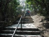
From the main trailhead these stairs lead to the top of Mount Bonnell.
The Hike: Mount Bonnell is more of a tourist spot than a hiking destination. Nevertheless it does provide a short trail to go along with the spectacular views that draw so many people there. The trail begins at the stairs leading up to the summit of Mount Bonnell, marked by the waypoint "Trailhead" on the topo map.

Mount Bonnell is generally considered the highest point in Austin at 775 feet, a fact which may or may not be true in the future as Austin expands in all directions. The peak is named for George Bonnell, who served as Commissioner of Indian Affairs for the Texas Republic. He first moved to Austin in 1839.

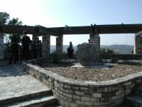
This pavilion marks the top of Mount Bonnell. it can often get crowded.
Known universally as Mount Bonnell, the peak actually resides in Covert Park, a name with which few Austinites would identify. The park is named in honor of the person who provided the land on which it sits, Frank M. Covert Sr. The park was transferred to the City of Austin in 1939, exactly 100 years after the arrival in Austin of the man who provides the name for the park's peak.

The hike is not particularly difficult - people of all athletic abilities "hike" it every day. But the initial stair climbing is a bit of a workout. This initial stretch of the trails accounts for most of the 190 feet of elevation gain encountered.

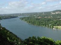
From the southern side of Mount Bonnell, looking south down Lake Austin.
A pavilion sits at the top of the mountain offering sweeping views, particularly to the west into the Hillcountry. Downtown Austin can be seen to the southeast, but you may have to find an ideal spot in order to get a completely clear view. Mount Bonnell served as a popular picnic spot as far back as the 1850's.

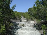
Although the trail at Mount Bonnell is short, there is quite a bit of stairs to climb, both natural and man-made.
Most of the people who visit Mount Bonnell congregate here at the pavilion and along the natural rock steps to the south. The "steps" are large slabs of rock that slope downward. Some of the steps are somewhat significant and require a bit of care. A couple of different Lake Austin views are possible from this vantage point.

Heading back up to the pavilion, the trail continues to the north. Like the south side, the trail here slopes downward, but the trail is composed of dirt and gravel and not the rough slabs of rock. There are somewhat fewer people here, but the views are every bit as exhilarating as those found south of the peak.

The northern trail strays a bit farther from the peak than the southern spur and then makes a sharp right turn and dumps out the hiker at the northern edge of the parking area. On busier days parking here may be easier the entrance at the waypoint "Alt-TH" can be used as a trailhead.

Photos
Downtown
Although it's not as easy to do as it used be, one can still catch a glimpse of downtown Austin from the top. (Photo by Austin Explorer)
Lake Austin to the north
From the north side of Mount Bonnell, looking north along Lake Austin. Note the Turkey Buzzard flying over the middle of the lake. (Photo by Austin Explorer)
Turkey Buzzard
Several Turkey Buzzards soared around Mount Bonnell looking for thermal updrafts and their next meal. (Photo by Austin Explorer)
View from Mt Bonnell
View of Lake Austin, looking southwest from Mt Bonnell. (Photo by omgjoz)
Log Entries
By Jamie on 3/1/2015
Rating: 4stars Difficulty: 3point5stars Solitude: halfstar
Distance: 1.00 Mile Duration: N/A
By jimmy peace on 2/22/2015
Rating: 3stars Difficulty: 3stars Solitude: 1star
Distance: 1.00 Mile Duration: N/A
Great View
By sswright84@gmaill.com on 3/21/2013
Rating: 3point5stars Difficulty: halfstar Solitude: halfstar
Distance: 0.31 Mile Duration: N/A
It is not a difficult hike, nor is it filled with solitude. But, it is an incredible view. I often take a picnic with me.
Quick trip up the mountain
By actualattic on 4/4/2012
Rating: 3point5stars Difficulty: 1point5stars Solitude: 1point5stars
Distance: N/A Duration: N/A

Had not been here in a several years, looks just about the same. Lots of people out and good views of expensive houses. A good place to take visitors or noobs to Austin.

By crocodile235 on 7/1/2011
Rating: 2stars Difficulty: 2point5stars Solitude: halfstar
Distance: 0.31 Mile Duration: N/A
Just too short...
By mgialusis on 1/26/2011
Rating: 2stars Difficulty: 1star Solitude: halfstar
Distance: N/A Duration: N/A

Very pretty but not what I would consider a hike considering it was so short.  I decided to climb the stairs across the street for the pretty view so it wasn't a waste of time...

Nice but short
By Melissa-Austin on 10/30/2010
Rating: 2stars Difficulty: 3stars Solitude: 1point5stars
Distance: N/A Duration: N/A

Not bad, very steep at parts, but not very traveled, as I got very scratched up fighting through branches.  Definitely too short for a hike.

Nice view
By aprylinparis on 5/29/2010
Rating: 3stars Difficulty: 2stars Solitude: 1star
Distance: 0.25 Mile Duration: N/A
Lots of steep man made stairs. The view was great at the top, but the location was crowded. Good place to take a quick hike to get a good view of the sunset.
Great but too short
By texaskdog on 3/6/2010
Rating: 5stars Difficulty: 3stars Solitude: 1star
Distance: 1.00 Mile Duration: 20 minutes

Great view, always crowded.  Too bad it doesnt connect to anything but Mayfield Preserve is an excellent add-on.  3 for difficulty because of all the stairs but they don't last too long. 

By HKB77 on 1/18/2010
Rating: 5stars Difficulty: 1star Solitude: 3stars
Distance: 0.31 Mile Duration: N/A

Only showing last 10 log entries. View All Log Entries

Recommended Item
Recommended Item Austin (Lone Star Guide to Austin)
Richard Zelade
Your price: $15.95 Buy Now
Lonely Planet Pocket Austin is your passport to the most relevant, up-to-date advice on what to see and skip, and what hidden discoveries await you. Jump into the icy waters of Barton Springs Pool for instant relief when the heat gets too much, catch a local band at the Continental Club or one of the hundreds of live-music venues around town, or watch the nightly exodus of America's largest urban bat colony during summer, under the Congress Avenue Bridge; at all with your trusted travel companion. Get to the heart of the best of Austin and begin your journey now!