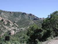
From the trailhead you can see where you'll be later in the day. Up there.
As you leave the Chisos Basin Lodge, take the only road
that leaves the Basin. As you get near the rim of Panther Pass look on the right for signs
indicating the trail and a small parking area to the side of the road. If you are coming in
from below the Chisos Mountains look on your left signs and a parking area.
The Hike: The Lost Mine Trail is perhaps the most important hike to
undertake if you only have a day to spend in Big Bend. It's not terribly long, provides
an interpretive guide to the plants, animals and geological formations seen in Big Bend
and it's not too far from the main park ranger station or the Chisos Basin Lodge rooms.
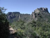
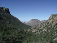
A view along the trail. Casa Grande is to the right.
The Lost Mine Trail is by no means a trivial hike. You'll cover almost 5 miles and climb
over 1,000 feet. The hike starts off at the waypoint "Trailhead" and gains altitude
immediately. However the first section of the trail features more gentle slopes than you'll
experience later in the hike, in case you're weary of climbing or don't have much time
to devote to the challenge.
-small.jpg)
The earlier portions of the hike include dense coverage of Pinyon Pine and other trees.
On your right you'll be afforded several magnificent views of Casa Grande Peak, one of the
more famous Texas mountains. At this point you'll be almost directly on the opposite side
of Casa Grande from the Chisos Mountain Lodge.
The waypoint marked "Lookout" is a great place to take a rest before continuing the
journey. Here you can find several rock outcroppings on which to sit and enjoy your first
view of Juniper Canyon leading to the south. You should also be able to see some of the
South Rim off in the distance.
The delicate balance of Big Bend's ecosystems is apparent along this ridge. The northern side is more lush.
If you look closely this spot also provides evidence of the fine line between desert shrub
and forest in the Big Bend. Towards the west a ridge rises to Casa Grande. On the south
side of the ridge relatively sparse shrub land is in contrast with the thicker forested
slope of the north side. Since the north gets less direct sunlight, slightly cooler
temperatures and better moisture retention Pinyon Pines and other plant species with
similar requirements can thrive.
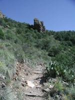
The terrain after the Lookout begins to get steeper, particularly once the switchbacks
show up, which should be fairly obvious on the map above. Here a reference point is the
waypoint "Big Rock". This stocky rock spire juts out of the mountain and marks about the
point which the switchbacks stop. The climbing won't be over at that point, but the
steepness will lessen somewhat.
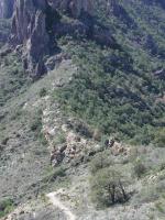
The switchbacks along the trail can be tiring. But concentrating on the rock outcropping ahead helps you keep focus.
Along these switchbacks on the way down we encountered our first rattlesnake on our trip.
He was sunning himself on a rock along the side of the trail. A couple in front of us was leery of passing along the trail with the snake there and tried to use a hiking stick to gently coax him away. The snake just calmly sat there and did not budge. Eventually they just hugged the opposite side of the trail and passed by, as we did. At no time did the snake rattle or make a move towards us. All he did was turn his head to keep his eye on
us.
Later, we asked a park ranger about the snakes and whether they caused problems for hikers.
The answer was a pretty convincing no. According to the ranger there have been 4 snake
bites in Big Bend in the last 20 years. It's a safe bet that some of those 4 attacks took
place after someone foolishly tried to handle or harass the snake. So your chances of being
in a car accident inside the park are probably greater than being bitten by a snake. When
you see a rattlesnake don't get too close, don't touch it or try to scare it. Just leave
it alone and it will almost certainly do the same for you.
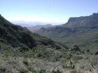
Looking down Juniper Canyon. The South Rim is in the distance slightly to the right.
After the switchbacks stop the trail continues up a relatively gentle slope to what appears
to be the peak. But it's not! The waypoint "Alt Peak" marks the spot you've been seeing
for some time. Once you get there you'll notice that the trail continues along a ridge,
now relatively treeless, towards the final peak. It's not farther and only slightly
higher, so there's no reason not to continue at this point.
Lost Mine trail gets it name from a legend that suggests that a secret mine existed in the area.
Workers were blindfolded before being brought to the mine to work. Thus, they could not disclose
the location of the mine. Legend says all of the workers were killed by local Comanche and
the mine closed up to hide its location.
Looking back towards the trailhead and the Chisos Basin further in the distance.
While the name of this hike is the Lost Mine Trail you do not actually get to the top of
Lost Mine Peak. You can see the trail's namesake to your left as you progress towards the
unnamed peak at the end of the trail.
The waypoint "Peak" marks the location of a real peak. The trail ends as the rock juts
abruptly upward to a point. You've reached the end. The peak provides an excellent
place at which to rest, have lunch and enjoy the views. Juniper Canyon and the South
Rim are still visible. Plus, the trip back to the trailhead is all downhill!
If you only have time for one hike in Big Bend, this is the one that we recommend. It is
of medium distance and difficulty and provides a maximum of views and information about
Big Bend. It is one of the more popular hikes in the park so you're not likely to go
without seeing other people for hours like you might on other Big Bend hikes.