Getting there: From the park entrance, drive down Park Road 5 into the canyon. Drive past the amphitheater and trading post. After the Old West Stables look for the next parking opportunity on the right, which should be just before the first water crossing.
The Hike: The Givens, Spicer & Lowry Running Trail is named for some of the people who are responsible for its creation. The original intention was to map out and create a trail of a specific length for use by the Palo Duro 50 trail run, which has been held since the mid-1980's. The race director's name is none other than Red Spicer. Don't let the "Running" moniker keep you away, hikers are welcome.
-small.jpg)
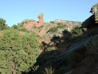
As the Sun comes up light strikes the red claystone slopes.
We started our hike at the waypoint "Trailhead". The start of the trail is vintage Palo Duro. The undulating terrain follows the edge of Timber Mesa, passing by steep and sometimes sheer slopes of red claystone, which sometimes break off to the touch. The trail surface is packed dirt and
a bit of rock.
As the trail turns around the eastern edge of Timber Mesa and turns to the west you'll soon come into view of a solitary hoodoo high over the canyon. Hoodoos are formed when weathering erodes softer rock around a cap rock that protects the softer stone directly beneath it. Eventually a column is formed.
-small.jpg)
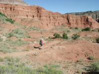
Coppertone pauses on the trail. If you look hard, you can see the Lighthouse formation off in the distance to the right. We'll be going there tomorrow.
Geological formations are not the only thing to see on the trail. On the trail we saw a laid back Collared Lizard and heard numerous turkeys. We were confident in our turkey call identification having just heard an example at a wildlife demonstration given by one of the park rangers the day before. Harvester Ants were very common on the trail, diligently returning to their colony with
seeds.
Coppertone hikes through a gully under the watchful glare of a hoodoo overhead.
What you don't see in person you can usually see by way of evidence. The sometimes sandy soil on the trail leaves many tracks of the animals that have passed this way over the last few days. A fallen Cottonwood tree laying across the river might be a common enough sight, until you notice its gnawed base. A beaver, one of the first ones to appear in the park in decades, had moved through the area and was preparing to make a home. Unfortunately the close proximity of people may have caused the beaver to move on as the rangers report that they have as of late not detected any
sign of him.
-small.jpg)
A strange collection of hoodoos could be seen from the trail.
At the waypoint "Junction" the trail comes to a "T" section. The trail to the left is known as the "Cottonwood Flats" trail and proceeds to join the
Lighthouse Trail to the south. The trail to the right is the "Little Fox Canyon Trail". At this point we took a right.
Eventually the trail on the Little Fox Canyon Trail begins to get a bit overgrown. Obviously, this part of the trail does not receive as much traffic as the trails closer to the trailhead and maintenance has not been done as recently. Like on other hikes, you have to take the official park maps with a grain of salt. The map shows a short feeder trail leading into a large loop. But that is not what the trail really looks like. It's actually a long feeder trail with a small loop.
Coppertone hikes the trail. The red sandstone dominates the lower levels of the canyon.
A very small, but steep hill rises above the canyon floor at the waypoint "Petite Teton". A side trail snakes its way to the top providing an overlook of the canyon. To the west, on the edge of the rim one can see houses, more than you'll see from any other vantage point in the park, which is somewhat of a drag, but they are far enough away that some sense of solitude is still achieved. After all, you are miles away from the trailhead.
If you get the feeling that you are being watched by someone other than residents in the houses on the rim, you are. Someone has placed several plastic birds along the trail near the turnaround loop. A pink Flamingo perches on top of a small hill, an owl stares as you turn the corner.
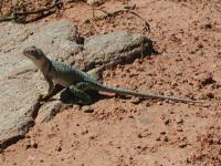
A Collared Lizard was sunning himself near an overlook along the trail.
When reaching the turnaround point of the loop be sure to sign the hiking log book that resides in the metal box there. We then completed the small loop and retraced our steps back to the main running trail. To complete the mapping we hiked the Cottonwoods Flats trail that connects to the Lighthouse Trail and then doubled back all the way to the trailhead. Once again, take the park map with a grain of salt. The Cottonwood Flats trail on the official park maps looks longer than it is.
We saw quite a few people on the trail, but we were the only ones hiking. Everyone else was either running or biking. Our out and back totaled 8.65 miles, making it the longest hike that we were to take in Palo Duro. The first few miles of the trail are the most interesting. Leaving out the Cottonwood Flats and Little Fox Canyon Trail won't cut out much of the scenery or difficulty since most of the ups and downs occur early. As an out and back you can tailor this to your tastes.