Getting there: The park resides on the north side of Bull Creek between
the creek and Spicewood Springs Road. From Hwy 360, take Spicewood Springs west for
about two miles. Be on the lookout on the left for a small parking area to the left with
a white mailbox. At this spot there is parking for at most 4-5 cars parked parallel to the
road. This is not the spot we parked in on this visit as it was already full.
Alternatively, proceed down Spicewood Springs for at most a quarter mile and look for
a larger parking area on the left. This parking area can hold about 15 cars.
The Hike: St. Edwards Park is a hidden gem in northwest Austin that most
people don't know about. Running along the northern bank of Bull Creek and Spicewood
Springs Road, its presense is missed by some who even drive on the road due in part its small
parking areas. However, the park is not devoid of people and its trail's close proximity
to the road reminds the visitor that civilization is close by.
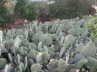
Right at the start of the trail is the largest single stand of cacti you'll see in the Austin area.
The trailhead for our hike is located at the "large" parking area, right next to the largest
stand of cacti you're likely to see. The large mass measures at least 10 feet across and is
the largest single stand we've ever seen. Just on the other side of the path smaller patches
of cacti indicate that the conditions right here for the plant are excellent.
-small.jpg)
The beginning of the trail is dominated by pocket prairies covered in grasses and wildflowers.
Follow the trail down to a T section, not far from the start. Take a right and proceed
down the trail through the park's pocket prairies. These small, treeless grasslands between
lines of trees host a number of wildflowers. At this time of year the Indian Blankets and
Brown-eyed Susans were out in abundance. As the trail gets closer to the creek the
grassland will give way to a heavy tree cover.
The bulk of the land that makes up St. Edwards Park lies in a bend along Bull Creek.
However, the majority of the hike is north of the bend along the thin ribbon of the park
that extends almost to the Oak Grove Cemetery. The trail heads toward the creek when coming
up to Y's or T's in the trail take a left to get to the waypoint marked "4-way". Turn
right at this point to start paralleling the creek. From now on the trail will be easier
to follow as they are few, if any possible detours.
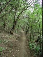
Most of the trail follows Bull Creek and is heavily wooded.
There are several waterfalls along the trail, the first of which is notable for one of the
trees that stands there. Many years ago someone decided to cut down one of the trees that
lines the bank of the creek. The tree had other plans however as it allowed the saw to
cut into it enough to grab hold and never let go. The lumberjack is long gone and saw
blade is rusty with age, but the tree remains and is growing around the saw used against it.
-small.jpg)
The main slot the waypoint Waterfall provides noisy, fast moving water contrasted with the still, quiet pools nearby.
Just north of the saw tree is a hidden box containing toys and trinkets. The
St. Edwards
cache is a part of geocaching, a modern day version of the treasure hunt that uses GPS
receivers to track down packages left behind by others. The game works such that anyone
finding the cache can take an item, but they must also leave an item for someone else.
The waypoint file listed below includes a waypoint for the cache, in case you want to
give the pastime a try. You can find out more about geocaching on Austin Explorer's
geocaching web page.
The best waterfall to be found on this hike resides at the waypoint "Waterfall". Here
most of the water flows quickly through a slot near the far bank. A broad uneven rock ledge
spans the creek and is covered with small pools of water intermixed with rock highpoints
providing footing to walk across. Two smaller waterfalls spill out over the the rock ledge.
The small pools of water provide an ideal habitat for tadpoles and small frogs, of
which there are many here. When walking across the rock please be aware of the pools
and the small frogs that might be hopping across the rock.
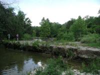
The main falls ledge provides excellent habitat for tadpoles. The main falls slot is on the other side of the couple pictured.
When the trail gets near the waypoint marked "Low Water Crossing" the trail will pass right
along the edge of Spicewood Springs. Be very careful when walking along this and other
stretches that pass close to the road for any wayward drivers. The low water crossing
is built on top of a small waterfall, which probably provided a stable platform of rock
for the road. The land on the opposite bank at this point is private land so keep that
in mind when looking for other trails on the opposite side of the creek.
The trail is not very hilly, though the evidence of hills abound. At the waypoint marked
"Cliff" a small side spur heads to the water and provides an impressive view of a shear
rock wall on the opposite bank.
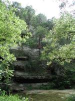
The hike is largely flat, but this cliff overlooking Bull Creek makes it presense known. This is still the Hill Country.
The waypoint "Turnaround" is the point at which the trail appears to end. We say appears
to end because it runs right into the road with no visible sign of continuation on this
side of the road. Spicewood Springs is crossing Bull Creek again and so the trail has run
out of land. However, there seems to be a trail that continues on the opposite side of
the road. We don't recommend proceeding across for 3 reasons. One, any trail that exists
on the opposite side ends shortly halfway up the hill. Two, the land may be private land
since it appears to be in some stage of development. Lastly, the land is rife with
garbage. Construction workers and/or local teenagers have littered the landscape with
various refuse including broken beer bottles. It is not the prettiest site to see, so
why waste your day on it?
The garbage at the end of the trail brings up a point about garbage at St. Edwards. While
not nearly as bad as the garbage dump mentioned above there was a bit more trash here than
we would like to see. On the way back to the trailhead we picked up as much trash as we
could fit into a trash bag we brought along just for that purpose. We could not get all
of it, but we made a difference. You can too. When hiking at this or other trails please
do your part and leave the trail in better shape than you found it.
All things considered, this is an enjoyable hike. We covered 2 miles out and back in
one hour and forty five minutes while enjoying Bull Creek in less crowded conditions than
can be found further downstream. It's an easy hike with very little elevation gain,
though you are still afforded a couple of beautiful views of the surrounding hilly
terrain.