Panther Canyon Nature Trail

Trail
1.90 Miles
110 Feet
Free
2point5stars (2.72)12
1point5stars (1.67)
3stars (3.08)
N/A
No
Yes
Yes
New Braunfels
Comal

Comal Springs is the largest spring in Texas, and the southwest.
Getting there: From I-35 in central New Braunfels take the Seguin Avenue exit and head west. Turn right onto Landa Park Drive and look for the trailhead sign on the left side of the road.

The Hike: The Panther Canyon Nature Trail is a relatively new trail that begins in New Braunfels' main park in the center of town, Landa Park. The hike begins at the waypoint marked "Trailhead". Already, the hiker is provided with a sight 
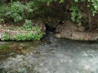
to behold. Just to the south of the trailhead lies Comal Springs, the largest in Texas and the southwestern United States. The highest recorded discharge from the springs was over 350,000,000 gallons in a single day in 1977. The water gushing from the springs twists a few times in Landa Park before joining the Comal River.

Although the walls of the canyon are steep, the trail itself follows the gentler creek bed.
The trail heads towards the northwest from the trailhead. In general the trail is well maintained with occasionally rocky surfaces, though packed dirt is more common. Most of the rocky portions occur at the trail's many creek crossings. In this short hike you'll cross the creek at least 10 times. Thankfully, the stream is usually dry, as it was on the day of my visit, and so provided no impediments.

About a tenth of a mile from the trailhead a small cave opening can be seen on the right. A quick peek into the opening showed an ascending slope covered in rocky debris, leading to pitch darkness. The cave could serve as a discharge point during wetter periods, but could also serve as the home for some wildlife. Alas, I could see no sign that would tell whether either of these were true.

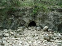
This cave lies near the trail, on the opposite side of the creek bed.
It's not that Panther Canyon is not an interpretive trail. I discovered more than 40 numbered stations throughout its length. Although some were destroyed by vandals, the majority appeared to be in their proper location. I had no prior knowledge of the interpretive markers and saw nothing at the trailhead which would help me learn more about the cave, or any of the other features that the markers highlighted.

A few segments of the trail are somewhat narrow, but none of it is overgrown.
Panther Canyon plays host to a dule of doves. White-winged doves seem to find the dense tree cover ideal for their purposes. A dule is a collection of doves, but strangely they can also be referred to as an arc, a cote, a cove, a dole, an exaltation, a flight, a flock, a funeral, a true love, a piteousness, a pitying, or a prettying of doves. Feel free to choose your favorite collective noun from the list. But the doves were not the only notable bird to be found. At one point I encountered a large Turkey Vulture hopping and darting, in a somewhat ungainly manner, amongst the branches near a creek crossing. Considering the bird's awkwardness I could see why I have seldomly seen them in such heavy cover.

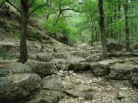
The trail crosses the creek that cuts the valley a number of times.
At the waypoint marked "Forked?" I took a wrong turn, unknowingly. I saw a trail lead off to the right, but thought the trail ahead was at least as well traveled, if not more so. Wanting to hike the trail proper and not any maverick trails, I proceeded to the left. By taking the proper right turn here the hike distance is probably equivalent, but the trail stops at New Braunfels High School. The fork to the left continues until it runs into Kentucky Street at the waypoint Turnaround, just a block or two from the school.

I encountered several people on the trail, but no crowds. This was somewhat surprising, particularly given that upon finishing the hike, back in Landa Park, I found the place to be packed with people, most of whom were picnicking or wading in the water downstream from the springs. It seemed that most people didn't even know the trail was there, just across the street from them. Perhaps that's for the best, at least for us.

Photos
Bridge
This creek crossing features a small wooden bridge. Others simply ford the dry creek bed. (Photo by Austin Explorer)
Smooth Trail
Tree cover along the trail is abundant. The foliage cuts down on the heat from the Sun and muffles the sound of the surrounding houses. (Photo by Austin Explorer)
Rocky Trail
Most of the trail is fairly smooth, but a few parts, like this one, is quite rocky. (Photo by Austin Explorer)
Panther Canyon Trail
Trail as it crosses dry creak bed (Photo by satterthwait)
Panther Canyon
Picture taken from dry creek bed showing bridge and part of trail. (Photo by satterthwait)
Log Entries
first time here
By jimmy peace on 10/27/2019
Rating: halfstar Difficulty: 1star Solitude: 1star
Distance: 1.00 Mile Duration: N/A

not much to write home about

Panther Creek NT
By J3NN1F3R on 1/30/2011
Rating: 1star Difficulty: halfstar Solitude: halfstar
Distance: 1.50 Miles Duration: N/A

My husband and I are locals to the New Braunfels, Canyon Lake areas and hiked Panther Canyon NT last Sunday. FYI as of jan 2011, all of the markers and half the bridges are gone. I would assume it was from last summer's flood. It is still navigable (and honestly should be refered to as a "walk" and not a "hike"), but if you were looking to take advantage of the interpretive map to learn about the nature trail, I would wait until the markers are replaced. Another heads up, without the markers identifying the end of the trail is not easy. All of the sudden you end up walking next to someone's backyard with their dogs going crazy.

By jcroley on 1/31/2009
Rating: 2stars Difficulty: 1star Solitude: 2stars
Distance: 1.90 Miles Duration: N/A
Cub Scouts
By Weilo on 7/7/2008
Rating: 4stars Difficulty: 2stars Solitude: 3stars
Distance: 1.90 Miles Duration: 1 hour, 30 minutes

Took the Cub Scouts out for a hike. Lots of different things to observe. Strange solitude with Landa Park  at the trail head.

Panther Canyon Nature Trail
By jcroley on 6/27/2008
Rating: 3stars Difficulty: 2stars Solitude: 4stars
Distance: 1.90 Miles Duration: 1 hour

Easy hike and we had it to ourselves. 

Great trail
By RMA on 1/26/2008
Rating: 3stars Difficulty: 3stars Solitude: 5stars
Distance: 1.75 Miles Duration: N/A

The trailhead is hard to find right at the spring. The bridges are in bad shape. In places the trail is hard to follow and is poorly marked.  All this makes it a fun hike.  

Short but sweet. Nice solitude among the city.
By ninjason on 3/5/2006
Rating: 3stars Difficulty: 1point5stars Solitude: 2stars
Distance: 4.00 Miles Duration: N/A
Always a great hike
By satterthwait on 5/14/2005
Rating: 4point5stars Difficulty: 2stars Solitude: 4stars
Distance: 1.90 Miles Duration: N/A
It is amazing how Landa Park is full of people, yet the Panther Canyon Trail is almost empty. -------------- The Parks department went to a lot of trouble this year and put in lots of signs and benches. Sadly, within two weeks almost all the signs are destroyed or defaced and even some of the benches are now broken. -----------------The hike was wonderful as always and usually takes about 35 minutes in and out (I do a small loop at end of the hike instead of just turning around-this loop takes you up one side of the canyon and gives a good short cardio work out---the loop is not on any official map, but is easy to find---when your almost to the end of the hike, the path forks- take the right fork which takes you up a short distance along the canyon. The trail is pretty easy to follow and leads you back down along the main trail within 5 minutes.
Great in the morning
By Luke on 11/14/2004
Rating: N/A Difficulty: halfstar Solitude: 4stars
Distance: 1.90 Miles Duration: N/A
I have no clue about that little cave. I've lived near this canyon since I was born. The best time (in my opinion) to hike this trail, if you want solitude, is the early early morning. But even if you can't make it early, it's still pretty deserted. There are several "non-trails" and some newer trails that have been cleared recently. The vandalism really isn't all that bad... it seems like the markers disappear halfway through (if you're coming from the park). Lots of graffiti on the bridge, but some of it is pretty creative. Depending on your personality, it probably won't be a problem.
Nice hike
By nlb on 6/3/2004
Rating: N/A Difficulty: 1point5stars Solitude: 4point5stars
Distance: 1.60 Miles Duration: N/A
We enjoyed the hike and even encountered a doe and her two yearlings. Our only disappointment was the presence of some obvious vandalism. It is a shame that some feel it necessary to destroy things for no reason.

Only showing last 10 log entries. View All Log Entries

Recommended Item
Recommended Item 60 Hikes Within 60 Miles: San Antonio and Austin: Including the Hill Country
Charlie Llewellin, Johnny Molloy
List Price: $18.95 Your price: $15.91 Buy Now
It's Time to Take a Hike in San Antonio!

The San Antonio and Austin areas are steeped in history -- San Antonio's Alamo stands as a symbol of Texas' fierce independence, while Austin is recognized as the cradle of Texas statehood. This area is also known for some of the most impressive hiking in the Lone Star State. 60 Hikes Within 60 Miles: San Antonio and Austin, by veteran authors Charlie Llewellin and Johnny Molloy, guides readers to the best trails found in the Texas Hill Country, all within easy reach of these two cities. The guide takes you to secluded, low traffic areas as well as those that are more popular and heavily used. The former LBJ Ranch, the Guadalupe River, the Highland Lakes Chain, and the Lost Pines area are just some of the spectacular places covered.

With this new edition in the best-selling 60 Hikes Within 60 Miles series, all these visually stunning and ruggedly charming routes are at the traveler's fingertips. This handy guide helps San Antonio and Austin natives get back into nature, with many options right in town. Extensive at-a-glance information makes it easy to choose the perfect hike based on length, difficulty, scenery, or on a specific factor such as hikes good for families, runners, or birding. Each trail profile includes maps, directions, driving times, nearby attractions, and other pertinent details.