Out Playground parking area > Chaparral > Winding Snake> Suzanne's Trail > Roller Coaster > West Potts Creek > Armadillo (East) 5.4 miles
Return East Potts Creek > Burkett > Burkett park > Suzanne's Trail > Lanky Lackey > Nature Loop > Tasajilla Flats > Playground parking area 5.0 miles
Temps low 60's to start and low 70's at end. Sunny and constant, STRONG westerly wind.
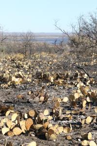
Park conducted controlled burns a few weeks ago and this is the first time I've been out there since. The area North from Playground parking area to an area South of Burkett park was burned. Smell of woodsmoke is still in the air. Saw a few deer and some rats as well as birds in the burned out areas.
With the vegetation burned, some trash is visible such as old cans and bottles so I pick those up when I can reach them.
NOTES
Water, shade, info kiosk and toilets available at Playground parking area.
Water, shade, info kiosk and dry toilets available at Burkett Park - at the midpoint of the figure 8 if you follow my route.