Out Playground parking lot > Tasajilla Flats Trail > Horny Toad Trail > Nature Loop > Lanky Lackey Trail > Roller Coaster Trail > West Potts Creek Trail > Armadillo Ridge (East) > East Potts Creek Trail > Burkett Trail > Burkett Park 6.8 miles
Return Burkett Park > Winding Snake Trail > Chaparral Trail > Playground Parking lot 2.8 miles
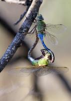
Walking along, listening to the birds, warm temps and constant light breeze, this hike was the epitome of a relaxing hike. Cottontail rabbits, lots of birds, lizards, a solitary frog and a roadrunner were some of the park's residents we encountered.
The trails are well marked and easy to traverse although there are a few areas where the rocks are more pronounced but all in all, an easy hike. If you go, please do not drop trash on the trails! If you pack it in, pack it out AND if you see trash, please pick it up.
NOTES
Water, toilets, info kiosk and some shade are available at the Playground parking area.
Water, dry toilets, info kiosk and shade are available at Burkett Park.