South Shore Playground to Armadillo Ridge and back

Looking North
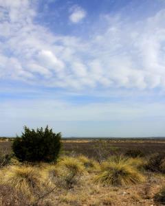
This view is from Roller Coaster Trail as I look to the North. The houses to the left of the juniper bush are in the Highland Ridge Housing Area which abuts the park.
User: MikeHikes - 5/1/2014

Location: San Angelo State Park

Rating: 5stars
Difficulty: 2stars  Solitude: 5stars
Miles Hiked: 8.60 Miles  Elapsed Time: 4 hours, 15 minutes

Comments:


Out      Playground Parking Area > Tasajillo Flats Trail > Nature Loop Trail > Lanky Lackey Trail > Roller Coaster Trail > West Potts Creek Trail > Armadillo Ridge Trail > East Potts Creek Trail Signpost               4.9 miles

Return  East Potts Creek Trail > Burkett Trail > Winding Snake Trail > Chapparal Trail > Playground Parking Area    3.7 miles

This hike is described in detail in my prior log entry of 4/16/2014 and titled "South Shore Playground - Armadillo Ridge Loop".

The temps were in the low 60's, a light breeze, lots of birds singing and in the four hours I was hiking, I saw only one mountain biker on the trails - what more can you ask for ?!?

For those sharp eyed readers who noticed the mileage discrepancy between my prior log entry and this one - I use a pedometer and although I try to keep the same stride on each hike, it is apparent I do not.  One of these days I may get a GPS unit and record precise mileage but until then, my pedometer is what I use as a mileage recorder.


Log Photos
Looking North
Area around San Angelo State Park
Recommended Item
Recommended Item Official Guide to Texas State Parks and Historic Sites: New Edition
Laurence Parent
List Price: $27.95 Your price: $24.27 Buy Now
Since it was first published in 1996, Official Guide to Texas State Parks and Historic Sites has become Texans’ one-stop source for information on great places to camp, fish, hike, backpack, swim, ride horseback, go rock climbing, view scenic landscapes, tour historical sites, and enjoy almost any other outdoor recreation.