North Shore Bell's Trailhead to Upper Ghost Camp Loop

Lace Cactus & Bee
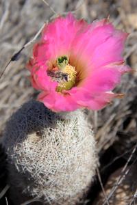
The lace cactus are blooming and the bees are busy! Take the time to observe and appreciate all the beauty in the park and don't worry about how fast you can hike, bike or ride the trails!
User: MikeHikes - 4/27/2014

Location: San Angelo State Park

Rating: 5stars
Difficulty: 2stars  Solitude: 4point5stars
Miles Hiked: 5.40 Miles  Elapsed Time: 2 hours, 15 minutes

Comments:

Out       Bell's Trailhead > Dinosaur Trail > Big Hill Trail > Badlands Trail (Horse) > Service Road  > Upper Ghost Camp     3.4 miles

Return   Upper Ghost Camp Trail > South Slick Rock > Scenic Loop > Service Road > Rocky Creek Trail > Service Road > Shady Trail > Bell's Trailhead    2.0 miles

This hike begins and ends at Bell's Trailhead located in the North Shore portion of the park.  The longest stretch is Dinosaur Trail which goes West and then South through mostly open areas before going into mesquite and prickly pear groves.  Near the actual dinosaur tracks, there is an info kiosk and water for humans and horse plus shade - no tables!  Continue on Dinosaur Trail which breaks at the Big Hill you will climb - this hill is the most difficult climb in the entire park!  Once you top the hill you will walk a short distance on the plateau; you can take either the trail to your left or the dirt road, until you come to the cattle gate.  Cross the gate and look to the right for the signpost for Badlands Trail (Horse & Hiker).

Suggest you take this trail and follow it to the end which is at a service road - River Bend Trail for Horse & Hiker is directly across the road and is marked as such.  Turn left (East) on the service road and hike it a short distance to the ghost camp where you will follow the road to the left - straight will take you down an old boat ramp.

A dry toilet, info kiosk and water for humans and horses is located here.  On the East side of the picnic tables, you will see a dirt trail - this is the Upper Ghost Camp Trail and you will go left (North) .  The trail ends at a cattle gate which you cross and you'll immediately see the signpost for South Slick Rock which you will take.  Follow it to the end and you will come to a junction.  Go slightly right on the service road and within 50 meters you will see the trail and signpost for Scenic Loop on the right.  Take it all the way and it will lead back to the service road once again, at a cattle gate.  

Cross the gate and there are a few benches under a shade tree.  The service road goes to the right but you want to look to the left at about 10 o'clock.  You'll see a service road which you will take for about a quarter mile at the most.  Watch for a signpost for Rocky Creek Trail on your right; follow the trail when you come to it.  This trail is an almost a straight line through prickly pear and mesquite trees.  At the end of the trail, you will come to a "Y" - take the left leg of the road.  You'll drop down the road and back up the other side.  Continue along the road and you'll see the signpost for Shady Trail.  Get on the trail and follow it back to Bell's Trailhead.

NOTES -

Water is available along the Dinosaur Trail approx 1 - 1.5 miles down the trial.  Water also available at the Upper Ghost Camp which may be called "River Bend Campground" on some maps.


Log Photos
Lace Cactus & Bee
Area around San Angelo State Park
Recommended Item
Recommended Item Official Guide to Texas State Parks and Historic Sites: New Edition
Laurence Parent
List Price: $27.95 Your price: $24.27 Buy Now
Since it was first published in 1996, Official Guide to Texas State Parks and Historic Sites has become Texans’ one-stop source for information on great places to camp, fish, hike, backpack, swim, ride horseback, go rock climbing, view scenic landscapes, tour historical sites, and enjoy almost any other outdoor recreation.