Park Mid-Section Eastern Loop

South Shore East Potts Creek
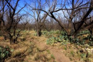
This is near the beginning of the East Potts Creek trail. Lots of mesquites; an easy to hike trail until you get near the end where it connects to Armadillo Trail.
User: MikeHikes - 4/10/2014

Location: San Angelo State Park

Rating: 5stars
Difficulty: 2stars  Solitude: 5stars
Miles Hiked: 5.50 Miles  Elapsed Time: 3 hours

Comments:

Out      Burkett Park > Burkett Trail > East Potts Creek > Armadillo Trail > Playground Trail > Flintstone Trail        3.2 Miles
Return  Dirt Road > Asphalt\Gravel\Dirt Road > Burkett Trail > Burkett Park     2.3 Miles

This loop will take you through the park's mid-section before returning along the eastern edge of the park .  Turn around point is where Turkey Creek, River Bend and Flintstone Trails meet.  The return route is along old park roads until you get to Burkett Trail.  

Enter through the South Shore gatehouse and drive a couple of miles to Burkett Park which is the trailhead for the Burkett Trail.  You'll head North along a hard packed dirt trail with a few sections of loose, small rock.  Lots of red earth here!  Near the mid-point of this trail, you'll walk beneath Pulliam Point on the left - this is the furthest point on the South Shore you can drive to.  Rounding the point, the trail is narrow, climbs slightly and full of small rocks.  Be aware of bicyclist on the trail - it is somewhat narrow and you will have to give way.

Follow the trail and at a small junction, stay to the right, you'll cross a bridge over a dry creek.  Continue straight to the end and you'll see a signpost for Potts Creek across a dirt road - this trail is actually East Potts Creek Trail although some maps, and Google Earth, call it "Armadillo Trail". 

East Potts Creek is mainly flat, hard packed dirt and meanders through mesquite groves.  Near the end of this trail you'll climb a bit and come to a signpost for "Armadillo".  Go to the right.

As you climb this trail, keep you eyes open when you reach the crest.  You'll see an abandoned picnic area and you need to look for a dirt path leading into the day use area.  Take the dirt path and follow it to a cattle water tank.  Near the tank, look for a straight dirt path that is a little to your right (about 45 degrees - North).  Follow it and you will connect to the Playground Trail.  Unfortunately, there is no signpost marking this trail but if you come to a road and look right, you'll see an abandoned pavillion shelter.  Cross the road and follow the trail. About 50 meters or so you should see another trail on your right, join this trail - continue to go straight.

Now, this is where having a laminated map of the trails (available for $3 at the South Shore gatehouse) comes in handy.  You will stay on the Playground Trail for quite awhile and it has switchbacks which may confuse you.  The trail is rocky and narrow in places as it takes you along the edges of some fingers of land.  Easy rule of thumb - the trail is very clearly defined and although there are a few loops in the trail, follow it generally ENE to Bell's Point, a local landmark where a marker, covered table and water is available. 

When you leave Bell's Point you are still on Playground Trail for a short while.  Again, no signpost but just follow the easily seen trail, not the old road.  The trail will take you down into a valley and through mesquite groves until you come to a dirt road.  At this point, you'll see a signpost for Flintsone Trail - once again, Google Earth does NOT show this, it says Playground Trail continues when it actually ends at this point.

OK, cross the dirt road and you're on Flintstone trail.  Follow it until you come to the junction of River Bend, Turkey Creek and Flintstone Trails which is on your left.  Water for humans and horses, an info kiosk and a shaded table are here.  Suggest you fill any water containers you have.

On your departure you will look East and see a straight dirt road - follow it.  This road is very easy to travel and will end at a water tank (I would NOT use it to fill my water containers but horses may drink from it).  Follow the bend in the road to the right and within 50 meters, you'll come to an old asphalt road.  Look to the left and you'll see a gate which is accessable for hikers but for this trip, you will go to your right and follow the asphalt road  heading West.  

Follow the road as is gradually drifts south and west and changes from asphalt to gravel.  When you come to a junction where the road changes to dirt on the left, go left (WSW).  Follow this road as it takes you back towards Pulliam Point and the signpost for Burkett Trail which you take back to Burkett Park and the end of this trip.

NOTES -

(1)  the Playground Trail is probably the least well marked trail in the park.  I believe there is only one signpost denoting this trail and it is where Flintstone ends and Playground begins.  I strongly suggest you look for the cattle tanks at the abandoned day use area on Armadillo Ridge.

(2)  Some of the official State of Texas Longhorn Herd is located at the park.  On this hike, I saw quite a few of these cattle on the other side of the fence right before I got on the asphalt road but I ran into some others wandering loose further along the road itself.  Leave them alone especially if calves are present.  

(3)  I cannot emphasize enough my suggestion to buy one of the laminated trail maps available at the South Shore gatehouse.  Cost is $3 and well worth it.

(4)  Suggest you do a satellite recon using the map linked to this report (I do not have the capability to mark my trial) and follow the route I took by going to the Earth view and looking at the actual terrain. 

Of note, Google Earth does NOT list Burkett Park or Burkett Trail.  Both are easily found though  by zoooming in where Lanky Lackey and Rollercoaster Trail meet.  Look to the  ENE and you will see a parking area with an out building and covered table; that is Burkett Park.  Burkett Trail begins here and you can easily follow it to the trail marked "Armadillo Ridge" which is an incorrect designation.  The signpost on teh ground reads "Potts Creek" and it is the eastern trailhead for the trail.  Google Earth also lists "Playground Trail as starting earlier than it really does at Armadillo Ridge (the abandoned day use area on the finger of land).

(5)  While some of my directions may be confusing, rest assured you cannot get lost in this park!  Western edge is FM 2288 and the Eastern edge is the dried lakebed.  On many of the trails, you can look around and see where you are in relation to the lakebed and some prominent landmarks.  For example, at one point along the gravel road on the return leg, I could clearly see my car parked at Burkett Park a few miles away.


Log Photos
South Shore East Potts Creek
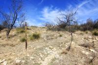
Armadillo Trail signpost
Playground Trail to Bell's Point
5 Points Junction
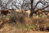
Resident Longhorns at the Park
Area around San Angelo State Park
Recommended Item
Recommended Item Official Guide to Texas State Parks and Historic Sites: New Edition
Laurence Parent
List Price: $27.95 Your price: $24.27 Buy Now
Since it was first published in 1996, Official Guide to Texas State Parks and Historic Sites has become Texans’ one-stop source for information on great places to camp, fish, hike, backpack, swim, ride horseback, go rock climbing, view scenic landscapes, tour historical sites, and enjoy almost any other outdoor recreation.