Caprock Canyons - Upper Canyon Trail

Trail
6.30 Miles
1050 Feet
$4.00
4stars (4.33)18
3point5stars (3.75)
4stars (4.25)
N/A
No
Yes
No
Quitaque
Briscoe
More Info

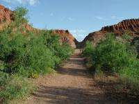
The trail near the trailhead pushes through a gap in the ridge ahead.

Getting there: From the park entrance drive north on the park's main road. Turn right at the fork in the road after Lake Theo. Continue driving past the Little Red Tent Camping Area and then look for trailhead parking on the right.

The Hike: Our hike begins at the waypoint "Trailhead" at a parking area with ample space, since we're the only ones here. The trail heads north from the trailhead with the John Haynes Ridge on the left.

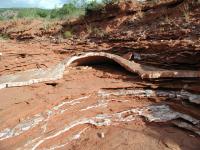
Caprock Canyons is loaded with Gypsum layers and they sometimes form domes or bubbles like this one.
Before starting the hike we noticed that the official park map warns that the Upper Canyon Trail was "extremely steep & rugged". Thinking that such a warning was geared towards the more casual visitor, we took the warning with a grain of salt. It turns out that the warning was well warranted.

For now, the trail is anything but steep and rugged. As it skirts the perimeter of the ridge the going is easy on the trail over the packed dirt and rock. Periodic creek bed crossing also mix in some sand for good measure. There's little to no shade at the start of the hike.

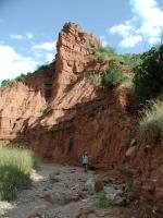
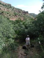
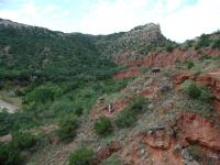
Coppertone on the trail. Eventually we'll end up in the canyon seen in the distance.
We had not traveled much more than a mile into the hike when we were surprised by a visitor on the trail. A young Coyote emerged from the brush and quickly high-tailed it down the trail away from us. It was the first time my wife and I had ever seen a Coyote on a hike.

By far, the most common animal that we saw on the trail was Quail. We unintentionally stirred up several coveys along the trail. Their sudden, unexpected bursts of mass flight from the brush as we passed by was startling at first. After about four incidents of this we got a little more used to it.

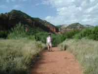
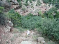
The trail at the lower elevations make frequent creek crossings. Here Austin Explorer poses near a cliff overlooking the creek.
When the trail heads west it will eventually start to gain in altitude following a stream bank. With the ascent the surrounding vegetation became thicker and tree cover began to provide some relief from the heat of the Sun we experienced up to this point. We saw numerous Oaks on the way up, something we don't recall seeing on our Canyon Rim hike nor at any point in Palo Duro Canyon.

Coppertone pauses for a water break after the trail turned steep on its way up the canyon.
The hike up the valley toward Fern Cave is very steep in places. But some added elements make the trek even more challenging. First, many of the trails in Caprock Canyon were overgrown on our visit, so the trail was not always perfectly clear and pushing through grasses was often required. At one point on the ascent the trail signs point to using the dry, boulder-strewn stream bed. The problem was, we failed to notice any sign indicating when to leave the stream bed. Eventually we followed a secondary stream bed that forked in the direction of the trail according to the park maps and we soon rejoined the official route.

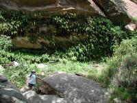
Fern Cave at the waypoint of the same name is a rock overhang covered in ferns that grow at the source of an Ogallala Aquifer spring. The constant stream of water here provides the required habitat for plants that could not possibly otherwise grow in this area. On the cliff overlooking Fern Cave is a small opening that might very well be a real cave in and of itself, though it is not accessible from the trail.

Austin Explorer stands on some boulders under the grotto near Fern Cave.
Even with all of the climbing that we've done, there is still some more to do before we get to the top of the ridge. So Fern Cave is a good spot to stop for a bit of a break. The final steps up to the top are steep and rocky and once you top out on the ridge you won't find as much shade as can be found here.

Fern Cave may be near the top of the bluff, but there's more altitude to be gained.
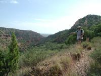
From the top of the ridge you can see Texas 256, the road just to the north of the park. The sound from the road is not too noticeable and most vehicles are largely hidden by the terrain. Thankfully this intrusion does not make its presence felt for very long on this hike.

The descent down from the ridge in some ways is harder that the ascent. A few spots are steep enough and covered in a suitable amount of scree that sliding a small section on one's butt seemed to be the safest choice. Boulder fields on the way down also obscure the route of the trail. Keep a close eye on the brown trail markers to lead the way.

Austin Explorer points to the bottom of the valley from which we came.
Also don't forget to pause every now and then and take a look around. The trail descends into South Prong Canyon. Once below the ridge line any sound from the distant road is long gone. What replaces that is the sound of hawks and numerous other birds throughout the canyon.

Coppertone slowly works her way down the steep trail.
The trail turns to the east after it hits the canyon floor. It follows a creek generally southeast and makes numerous creek bed crossings. None of the crossings presented any problems as we encountered no water. However the sand patches get quite large and thick in this area and one might picture a beach stroll instead of a Panhandle hike.

The trail proper ends at the waypoint "Alt-TH". A small, separate spur also leads to the parking lot near the end of the trail. There are two ways to get to the starting trailhead, turn around and double back up and around the ridge, or walk along the park road towards the northeast. The later option is the one we took considering that we'd already gotten a good workout for the day.

In the end we hiked almost 6.5 miles, not counting the trip back to the car. While we did see some vehicles in the distance on Texas 256, we saw no one else for the five hours or so we were on the trail. This trail lived up to its billing as steep and rugged, but the views from the top of the ridge made the effort worth it.

Photos
Steve & Erica
This was just after we climbed up the middle trail and stopped at the overlook. Lucky to meet someone who could take our picture for us! (Photo by texaskdog)
View From The Trail
This is another example of the beautiful and interesting rock formations you'll see along the trail. (Photo by Blaze)
Gypsum Crystals
These white, brittle crystals are made of Gypsum. (Photo by Blaze)
Fern Cave
On the other side of the ridge, you can take the trail to Fern Cave. (Photo by Blaze)
Beautiful Vistas
The trail takes you up a steep ridge, but you are rewarded with stunning views of the canyon below. (Photo by Blaze)
Beautiful Rock Formations
There are impressive rock formations throughout the canyon. (Photo by Blaze)
Entrance Sign
This is the sign to the park. (Photo by Blaze)
On the way back
A view on the way from Fern Cave back to the trailhead. (Photo by JHager)
Eroded rock wall
An eroded rock wall reached from Haynes Ridge just before you get to Fern Cave. (Photo by JHager)
On the ridge
The (fallen) sign indicating you're on the Hayne's Ridge trail. (Photo by JHager)
The way up
Flowers growing out of a rock on the way up to Haynes Ridge. (Photo by JHager)
The gap
A gap in the road shortly before you get to the cutoff for the Haynes Ridge trail. (Photo by JHager)

Only showing last 12 photos. View All Photos

Log Entries
Great hike probably best in the park
By texaskdog on 7/4/2014
Rating: 4stars Difficulty: 3point5stars Solitude: 3stars
Distance: 7.00 Miles Duration: 4 hours

We took the middle trail up the hill figuring it would be better to do it on the way up.  Big mistake as we had to walk the northern part of the loop (hot desert) in the hottest part of the day.  Up on top it is quite cool and gradual.  The north side was nice but yes would be best going up the north side and coming down the center (we didn't take the south side)

Beautiful Challenging Hike
By brazosbound on 3/17/2010
Rating: 5stars Difficulty: 4stars Solitude: 4stars
Distance: 7.50 Miles Duration: 7 hours, 15 minutes
By Rowdius on 12/20/2009
Rating: 4stars Difficulty: 2stars Solitude: 3point5stars
Distance: 6.30 Miles Duration: N/A
Great hike through red rock bluffs
By Redwolf on 9/13/2009
Rating: 4stars Difficulty: 4stars Solitude: 4stars
Distance: 6.30 Miles Duration: N/A
We've done this one twice now. The first time we didn't bring enough water and were staggering as we came out. There's a lot of elevation change on this hike, over 1000 feet. We stopped at the butterfly grotto for lunch, enjoying the cooler temps.
Family Hike
By TCummins on 6/2/2009
Rating: 4stars Difficulty: 3point5stars Solitude: 4stars
Distance: 7.50 Miles Duration: 5 hours, 30 minutes

Took the family (5) on this hike from the South Prong up to Fern Cave then back along the Haynes Ridge Overlook Trail and down the Canyon Loop Trail back to the parking and main road, and finally back up the road to the South Prong parking lot.  Wow! What a hike with the wife and three kids (12, 9, and 7yrs).   Beautiful scenry! Got some great pictures. It down poured the night before so there were lots of critters too.  Roughest and most difficult part of the hike was up to Haynes Ridge from the South Prong.  Rocky and steep.  The trails have lots of brush in spots so long pants are a good idea.  Take plenty of water with you on this one.

Warm, but enjoyable
By JHager on 5/23/2009
Rating: 4stars Difficulty: 3stars Solitude: 4stars
Distance: 6.30 Miles Duration: N/A

I hiked the Upper Canyon trail on a warm, muggy day in May of 2009.  It’s a nice area and an enjoyable hike, but by that time of year, it’s starting to get warm, so begin the hike early.  The views from Haynes Ridge are great and Fern Cave is also interesting, so bring a camera with you.  I saw quite a few lizards, but no other wildlife.  The only other people I saw were a couple of mountain bikers shortly before I returned to the parking lot.  My timing turned out to be pretty good, because the area was hit with a huge thunder storm an hour or less after I finished.  By that time, I was ordering pizza and a cold drink in a small town about 40 miles (or so) west of the park.  It was a good hike, but probably better in the cooler months when heat and storms aren’t a concern. 

By rodavenport on 4/25/2009
Rating: 5stars Difficulty: 4stars Solitude: 4stars
Distance: 10.50 Miles Duration: 5 minutes
By rodavenport on 4/18/2009
Rating: 5stars Difficulty: 4stars Solitude: 4stars
Distance: 7.50 Miles Duration: 5 minutes
Beautiful red rock canyon
By rodavenport on 4/11/2009
Rating: 5stars Difficulty: 4stars Solitude: 4stars
Distance: 7.50 Miles Duration: 4 hours, 30 minutes

Nice cool early spring day. Lots of people hiking this day. Take heed of the rough& rugged trail warning. The climb up and over Haynes Ridge is fairly difficult especially if you are climbing from the South Prong. Also I highly recommend long pants unless your skin is like leather. The upper end of the North Prong and the climb up over the ridge and back down has a lot of growth on it.

Trails Galore! At Caprock Canyons
By Blaze on 8/21/2008
Rating: 5stars Difficulty: 4stars Solitude: 5stars
Distance: 8.00 Miles Duration: 4 hours

If you like hiking, you'll find plenty of trail in and around the Caprock Canyons State Park.  There are a couple of scenic trails within the park itself as well as a LOT of lengthy trails along the Trailway, including The Plains Junction Trail (10 mi), Grundy Canyon Trail (12 mi), Oxbow Trail (10 mi), Kent Creek Trail (10 mi), Los Lingos Trail (5 mi) and Quitaque Canyon Trail (17 mi).

I only hiked within the State Park, not along the Trailway.

I camped at the South Prong Tent Camping Area, so my hike departed at the parking lot.  This trail provided breathtaking vistas of cliffs and canyons, so remember to bring your camera!  The Upper Canyon Trail was a fairly easy hike until you reach a section where you have to ascend an extremely steep and rugged cliff that takes you from 2,500 ft in elevation to 3,100 ft.  It is not an easy climb, so I would not recommend it for elderly or people in below average health.  I had just finished a 10 mile hike the day before in Copper Breaks State park so my legs were still aching, which made this ascent more difficult than usual.  Once you get to the top, you are afforded some beautiful views, making the ascent worthwhile.  From the top, you can continue along the crest on the Haynes Ridge Overlook Trail (2 mi) or to descend along Upper Canyon Trail towards Fern Cave.  The cave sounded interesting, so this is the route I took.  The cave proved to be an interesting site with large boulders and lots of moisture and ferns.  At this point, however, I found the trail to be poorly marked and I got off trail several times once I left the cave.  It wasn't a big problem, however, because at this point in the hike you are essentially hiking along the bottom of the canyon adjacent to a small winding stream.  You can't really get lost since mountains surround both sides of you.

Once I got out of the canyon, I hiked back towards the North Prong Primitive Camping Area.  There were several trail marker signs indicating trails like D1, C2, etc., but I was a little frustrated because these trail numbers do NOT appear on the provided trail map.  Consequently, it would be easy for a hiker to take the wrong trail if he did not have a compass or good orienteering skills.  Luckily, I took the right trail (Canyon Loop Trail) back to the parking lot and then along the paved road back to the South Prong Camping Area parking lot.

As I mentioned before, I found this hike to be challenging, but very rewarding in terms of scenery.  Be sure to take plenty of liquids with you and allow enough time for a slower than usual pace.

There are several other trails in the park, such as Eagle Point Trail, the Lower Canyon Trail, Mesa Trail, and Canyon Rim Trail, but I did not hike these trails on this trip.  This is a beautiful state park, so this provides me an excuse to go back! :-)  

Only showing last 10 log entries. View All Log Entries

Recommended Item
Recommended Item Official Guide to Texas State Parks and Historic Sites: New Edition
Laurence Parent
List Price: $27.95 Your price: $24.27 Buy Now
Since it was first published in 1996, Official Guide to Texas State Parks and Historic Sites has become Texans’ one-stop source for information on great places to camp, fish, hike, backpack, swim, ride horseback, go rock climbing, view scenic landscapes, tour historical sites, and enjoy almost any other outdoor recreation.