Palo Duro - CCC Trail

Trail
6.80 Miles
1000 Feet
N/A
4stars (4.23)13
3stars (3.00)
3point5stars (3.88)
N/A
No
Yes
No
Canyon
Randall
More Info

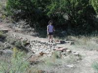
Coppertone hikes near the trailhead over a bridge first constructed by the Civilian Conservation Corps in the 1930's.
You will not find this hike on the official park map or any park literature that we've come across. When stopping by the visitor center to view the exhibits and take in the view from the rim of the canyon we were intrigued by a small yellow sign that indicated this was the trailhead of the Triassic Trail.

It seemed to indicate that it was open to the public, but was it really? When we asked visitor center volunteers they had no clue the trail even existed. A park ranger at the park entrance finally had an answer for us. The old trail was indeed open, though reclamation work remained to be done. The trail was apparently built at the time of some of the original Civilian Conservation Corps work in the 1930's. The trail had been abandoned for years, but was now receiving the attention it deserved.

We knew the trail was open, but where did it go? The park ranger described the route he remembered and we believed we knew where it had to end up. Seemingly, this would not turn out to be that long of a hike, so we planned on tackling it after doing the Lighthouse Trail. We were in for a surprise.

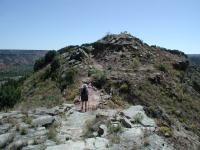
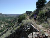
The Triassic Trail provides some of the only canyon top hiking in the park. Here Coppertone traverses a ridge between peaks.
Our hike begins at the waypoint "Trailhead". The path heads north and follows the contour of the canyon rim. The trail surface is rocky with packed dirt. Unlike hikes on the canyon floor, Triassic does not have lots of sandy patches. Several CCC trail features dot the trail including small stone bridges that traverse stream beds along the way.

After the trail turns to the east it begins to descend in altitude until it reaches a ridge leading to Goodnight Peak to the south. Once on the ridge we reach a fork in the trail. The path to the left leads to a small parking area in a bend of the main park road. This is the trail terminus that we expected based on the park ranger's description. But where did the other trail lead to?

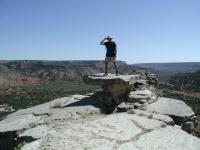
The Table Rock formation on the turnaround point. The rock sits on a promontory point and has spectacular views. The high winds required a wide stance.
Not content to leave that question unanswered we ventured off and followed the ridge line south. By now the trail skirted the eastern edge of the ridge and overlooked the main park road as it descended to the canyon floor below. Cars straining to climb or braking on the way down drove by. A couple came to a complete stop. Were they taking in the view? It didn't seem like the spots where they stopped provided a canyon view, but they did provide a glimpse of US. I think they actually wondered what people were doing all of the way up there.

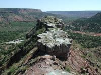
The Table Rock is not at the end of the ridge, but it is at the end of the hikable ridge. Down below to the left are horse stables that used to host a miniature railroad from the 1950's to the 1990's.
The ridge narrows quite a bit sometimes to a width not substantially wider than the trail itself. Here the hiker is afforded spectacular views of the canyon both to the east and the west. Unlike all of the other hikes in the park, this is the only one at the canyon's rim and provides unique views of the canyon from above and not below the rim.

As the ridge begins to widen a bit another fork in the trail appears. What now? We've already been surprised by what we'd found and weren't about to let our curiosity go unfulfilled. We took the fork on the right and continued on the ridge to the south. The ridge widened and flattened. Rock gave way to grasses and brush. The trail became a bit overgrown and we expected the trail to peter out any moment.

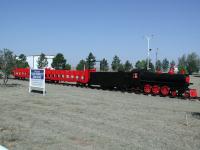
You can actually see the miniature railcars in the front yard of the family that used to run the operation in the park. This located just a couple of miles from the park. Liability insurance rates shut it down.
Just when we thought we had exhausted our interest in this portion of the trail we came upon end of the line. We reached the southern-most limit of the ridge and came upon a rock promontory jutting out into seemingly mid air. On this point stood a natural table rock. A single piece of rock with a single support stuck right at the edge of the promontory like it was placed there for a reason.

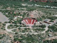
A different kind of view of the Texas amphitheater on the canyon floor.
It's not exactly dangerous to get the table, but the rock walkway leading to it is narrow. It's narrow enough that you lose your peripheral vision's connection with the mountain beneath you. For some with a bit of vertigo, such as my wife, that was a little too much to handle.

The view from the point is spectacular. Just to the east, a few hundred feet below lies the amphitheater where the musical "Texas" had entertained park visitors for years. To the southeast, the park's riding stables could be seen. To the west, Timber Creek. To the east, the Prairie Dog Fork of the Red River. I could have stayed there for hours.

There's a small deteriorating shed near the table rock. Wiring laying about the structure and its placement on the ridge above the amphitheater led us to believe that it may have played some part in play productions in the past. We completed the small loop at the southern end of the ridge and doubled back to the fork in the trail. Since we'd had good luck so far we decided to follow the other trail as far as it would take us.

Coppertone was denied the opportunity to climb this very hill from the amphitheater as a child. She got to this time around!
The trail descends the slope of the ridge and then snakes through several monstrous switchbacks headed downhill. Some portions of the trail had been reinforced with logs and pylons, so we knew we were not off trail. However, the trail had several rock slides that had covered the trail for short distances. We'd come up to a rock slide, think we'd done all we could, and then spot the continuation of the trail on the other side of the slide. We climbed over and kept going.

Coppertone hikes up the switchbacks from the canyon floor. Eventually we hike back all of the way to the information center at the canyon rim.
The trail finally ended in the parking lot of the amphitheater at the bottom of the canyon. At the base of the mountain Coppertone had a memory flashback. When visiting the park as a child she had wanted to climb this very mountain before a performance in the amphitheater and her parents would not let her. After all of these years she had finally done it.

We had hiked all of the way from the top to the bottom of Palo Duro. What now? Hitch a ride back to the visitor center? No way. We turned around and hiked back up the switchbacks to the top of the ridge and retraced our steps to the trailhead.

This trail was by far our favorite in Palo Duro, from a pure hiking perspective. The sense of mystery surrounding the trail and the high vistas it afforded put a great cap on our Palo Duro trip. In three hours of hiking over four miles we didn't see another person on the trail. We had it all to ourselves.

Photos
Pioneer Nature Trail
The Pioneer Nature Trail is a short loop along the valley floor. (Photo by Blaze)
View Of The Trail
The CCC trail is well-marked and distance markers are placed every 1/10th of a mile. (Photo by Blaze)
Scenic Views
The CCC trail offers spectacular views of the entire park. (Photo by Blaze)
CCC Trail
Nice Views! (Photo by jmitchell)
CCC Trail
Deer (Photo by jmitchell)
CCC Trail
Steep in some places (Photo by jmitchell)
Table Rock
One of the unusual rock formations in the canyons. (Photo by rowdy)
Triassic Trail
Scenic view of the canyons from the Triassic Trail. (Photo by rowdy)
Log Entries
CCC Trail & Pioneer Nature Trail
By Blaze on 9/1/2013
Rating: 3stars Difficulty: 2stars Solitude: 2point5stars
Distance: 4.70 Miles Duration: 1 hour, 59 minutes

I started hiking the CCC trail by parking my car at the top of the hill in the parking lot near the Visitor's Center.  I then hiked the CCC trail down to the Amphitheater, then crossed the street to hike the Pioneer Nature Trail loop.  I then hiked the CCC trail back (uphill) to my car, which provided a good cardio workout.

I found the CCC trail to be very scenic.  The views from the ridge are very impressive.  It is a short hike that I would definitely recommend.

By contrast, I found the Pioneer Nature Trail to be disappointing.  It really didn't impress me in any way.  It's just a short dirt trail to walk on and not a trail I would recommend.

Great Views
By Chinacareys on 11/27/2010
Rating: 3point5stars Difficulty: 3stars Solitude: 3point5stars
Distance: 4.00 Miles Duration: N/A

This trail has been renamed the CCC trail.  It has some great views of the canyon.  Don't let the crowd at the parking area discourage you.  Most just get out  take a look then get back in their cars and leave.

Beautiful Hike
By jmitchell on 9/4/2007
Rating: 5stars Difficulty: 4stars Solitude: 2stars
Distance: 4.50 Miles Duration: 2 hours, 30 minutes

Trail descends rapidly and hugs the canyon wall. Lots of road noise on the entire trip. Encountered lots of spiders along the way. Also saw numerous deer. Nice touches on the trail such as resting benches and bridges. Came to a fork, left basically ends shortly at the road with no where to go, right fork (marked amphitheater) is the way to go. Mid way is fairly easy going with nice views, then you reach another fork in the trail. Left goes down to the Amphitheater (I did not take this trail, It apeared to be very steep and I was hurting still from the previous days hike at Caprock Canyon) the right fork takes you out to the point. Spectacular views and if you are brave enough you can venture all they way out to the point (not me!)

I saw no one else the entire trip. Overall, this was a very enjoyable early morning hike.

One of the most scenic trails in the park
By rowdy on 10/28/2006
Rating: 3stars Difficulty: 3stars Solitude: 4stars
Distance: 6.80 Miles Duration: 2 hours, 30 minutes

This trail is not on the map that they pass out at headquaters.  Found it on this website.  It is a very enjoyable hike with some of the best scenery in the park.  We went to Table Rock and then worked our way down to the Amphitheater before we headed back.  There was very little traffic on the day that we went.  There is a bench along the way that is fun to sit and watch the cyclist climb the steep grade back out of the canyon.

Great trail to see the park
By ksd823 on 7/14/2006
Rating: 4stars Difficulty: 2stars Solitude: 5stars
Distance: 6.00 Miles Duration: N/A
This is a great trail to see the park. We started at the center traihead, hiked to the Table Rock over the Texas Stage, then went back to the Observation Point parking lot, then back to the center trailhead. Trail is in excellent condition, with two closed bridges but easy walkarounds. Only saw one other person on Friday, but saw many more on Saturday. There are several side trails to great views - don't miss those.
Best Scenic Trail at PDSP
By chris1401 on 4/14/2006
Rating: 4stars Difficulty: 3stars Solitude: 4stars
Distance: 4.00 Miles Duration: N/A
This trail is a gem, hard to find and for good reason. This trail offers hikers of all abilities a treat for the eyes. In my opinion after a few years of exploring Palo Duro, this trail has it all. A few inclines and declines, a decent length and the bet view of the canyon from a trail. Next time you get to Palo Duro, stop at the visitors center after you get into the park, but before you go to the canyon floor. Look for the yellow sign in the parking lot, this will signify the start of the trail. Take it and be amazed. At the first fork I suggest going to the right. Make sure you follow the trail to the end and look for the table rock to signify that. Then look down to your left for a treat. Happy Hiking.
Wonderful new Trail
By LVX on 11/27/2005
Rating: 3point5stars Difficulty: 2stars Solitude: 2stars
Distance: 7.00 Miles Duration: N/A
I worked down in Palo Duro Canyon when I was in highschool and hiked a great portion of the canyon. I am glad they have uncovered another historic trail. You can also get a great view of the canyon from just about everywhere. If you hike on down to the ampitheater and then back up, you can get a little extra mileage as well as a tough hike back up. Perfect afternoon..
The best pure hike in Palo Duro!
By Austin Explorer on 9/26/2005
Rating: 5stars Difficulty: 4point5stars Solitude: 4point5stars
Distance: 4.20 Miles Duration: 2 hours, 50 minutes
This old CCC trail starts at the information center and is being reclaimed and doesn't appear on the park maps, but it is open. We didn't really know where this would take us and we were pleasantly surprised. This is the only hike up on the rim of the canyon, giving a completely different viewpoint than other hikes. It leads to numerous overlooks and a sidetrail of steep switchbacks leads down to the Texas amphitheater. If you really want a hike for hike's sake, this is the one to do. We saw no one else on the trail, just people at the information center or on the road wondering how we got up there.
favorite palo duro hike
By kegalina on 5/5/2001
Rating: 5stars Difficulty: 3stars Solitude: 5stars
Distance: 2.00 Miles Duration: 1 minute
I used to hike this trail almost weekly when I lived in Canyon. If you want solitude and a bit of that pioneer feeling, this is a good trail. There are parts of this trail that are a bit wild as nature has taken control of some of the areas. Painted buntings can be found in the junipers along the ridge that follows the road from the visitor's center. There is a large area of flat rocks that extend from this ridge that overhang an area shaded by large trees, both junipers and deciduous. That is where I could always find the elusive little birds. but be very quiet! The trail is especially nice early in the morning in the spring when there is a fog settling in the canyon. You are almost guaranteed to run into some deer on the trail. They aren't used to seeing a lot of people in this area of the park.

Only showing last 10 log entries. View All Log Entries

Recommended Item
Recommended Item Official Guide to Texas State Parks and Historic Sites: New Edition
Laurence Parent
List Price: $27.95 Your price: $29.95 Buy Now
Since it was first published in 1996, Official Guide to Texas State Parks and Historic Sites has become Texans’ one-stop source for information on great places to camp, fish, hike, backpack, swim, ride horseback, go rock climbing, view scenic landscapes, tour historical sites, and enjoy almost any other outdoor recreation.