Balcones Canyonlands NWR - Warbler Vista

Trail
1.80 Miles
N/A
N/A
3point5stars (3.83)30
2stars (2.36)
3point5stars (3.70)
N/A
No
No
Yes
Lago Vista
Travis
More Info

The Cactus Rocks trailhead.  Trail guides are available nearby.
The Cactus Rocks trailhead. Trail guides are available nearby.
Getting there: From Highway 183 in Cedar Park turn south onto FM 1431 and drive for about 14 miles, passing through Lago Vista. On the west side of Lago Vista look for the Balcones Canyonlands NWR sign on the right and turn onto the gravel road. Drive up hill on the gravel road for three quarters of a mile and park next to the interpretive trail guide display.

The Cactus Rock part of the trail follows along a ridge, just below some rimrock.
The Hike: The Balcones Canyonlands National Wildlife Refuge is administered by the U.S. Fish and Wildlife Service. It's name causes some to confuse it with the separately administered Balcones Canyonlands Conservation Program. The two efforts share a common goal of setting aside vital habitat for endangered species, such as the Golden-cheeked Warbler and the Black-Capped Vireo.

For hikers, the preserve offers an added benefit of some fine hiking opportunities. The refuge consists of several large tracks of land in western Travis County and eastern Burnet County. The Warbler Vista parcel includes two trails that we connect together for this one hike.

Only the portions of the trail with a view a couple of others break out of the heavy vegetation.
Near the waypoint "Trailhead" one can find a display with interpretive trail guides that provide insight into the geology of the area and the species that make their home here. Along the trail, markers indicate which numbered section of the guide describes a feature or species present. The markers on this trail are the best I have seen anywhere. They're like a piece of art all it's own.

Our hike heads west on what the refuge calls the Cactus Rocks Trail. It follows a contour near the top of a ridge, just below some rimrock. The trail along the ridge is not terribly uneven, save for a couple of quick descents and ascents to traverse dry gullies. Generally there is plenty of cover provided by Ash Juniper, Spanish Oaks, Live Oaks and even some Shin Oaks.

The Vista Knoll portion of the trail tends to be rockier and a bit more challenging.
The name for this trail comes from some cacti that appear to be growing out of large limestone boulders. Actually, the fractured, pitted and uneven surface of the rock allows the collection of enough soil to support some plants, including cactus, which can be seen near the interpretive guide station number 8.

Approximately half a mile into the hike the trail intersects what the refuge calls the Vista Knoll Trail, a 1.2 mile balloon route that starts at the "Alt Trailhead" waypoint. Turn to the left and head south to get great views of Lake Travis and the hillcountry.

The loop trail almost encircles a small hill, providing views from many angles.
The Vista Knoll portion of the hike is a bit more challenging that Cactus Rocks as it descends down a backbone ridge and back up to the knoll from which the trail derives its name. There's rockier terrain here and less tree cover, both of which help contribute to it's spectacular views.

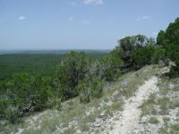
The waypoint "View" at the southern-most tip of the knoll loop marks the best location for sightseeing. The spot provides a wide vista showing miles of hillcountry punctuated by a twisting Lake Travis in the distance.

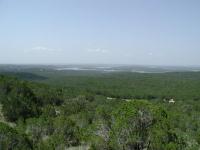
Lake Travis can be seen in the distance, winding its way through the hillcountry.
Completing the loop and doubling back to the original trailhead will result in a hike of just under 2 miles. Proceed quietly down the trail and you might happen upon some of the wildlife to be found in the refuge. On our visit we observed White tail deer, butterflies, dung beetles, a lizard hunting moths in the leaf litter, and a baby praying mantis, which I had never seen before. Unfortunately we made no sightings of the birds for whom the preserve was created.

FM 1431 provides easy access to the refuge, but it also presents something of a mild nuisance. The traffic zooming by at high speeds create noise that is never truly overwhelming, but never totally absent. Less noise and fewer reminders of civilization so near by would make this hike almost ideal for a short and easy stroll through the hillcountry.

Photos
Another view of the hills
I never get tired of views such as this. (Photo by heatharcadia)
Scenic 1431
A view of 1431 winding through the hills. (Photo by heatharcadia)
View of Lake Travis
This is one of the views of Lake Travis you get on the trails here. (Photo by heatharcadia)
Close up of the rattlesnake.
He was not happy. This was on the upper (open) section of Cactus Rocks trail. (Photo by wolf2600)
Rattlesnake on the Cactus Rock trail 29 Mar 2014
Almost stepped on this guy. Looked down, heard the rattle, jumped back as he coiled up. Decided to turn around and go back the way I came. (Photo by wolf2600)
View from Warbler Vista "Vista Knoll" Trail
A nice view from along Vista Knoll Trail (Photo by jeffyg)
Leanings
Here the trees all seem to be leaning in the same direction. (Photo by Austin Explorer)
Marker
The interpretive guide marker stones here are the best I've seen anywhere. (Photo by Austin Explorer)
Towards Lago Vista
Look from the trail towards Lago Vista. FM 1431 can be seen cutting through the terrain. (Photo by Austin Explorer)
Another Trail View
The trail opens up at the vista knoll and near the alternate trailhead. (Photo by Austin Explorer)
Just past the trailhead
Just past the trailhead (Photo by Riff Raff)
Several birds of prey out
Several birds of prey out (Photo by Riff Raff)

Only showing last 12 photos. View All Photos

Log Entries
Nice views, just wish it was longer and quiter
By heatharcadia on 1/3/2016
Rating: 3stars Difficulty: 2stars Solitude: 3stars
Distance: 3.44 Miles Duration: 2 hours, 12 minutes

These trails are all pretty easy and short, so this is the ideal place to go hiking if you want to combine it with a day out in the Hill Country. There are some nice views of Lake Travis, but unfortunately most of these views include 1431. You can also hear traffic noise from 1431 on all parts of the trail, which takes away from the feeling of solitude.

Bring binoculars because the Sunset Observation Deck has some nice views that are enhanced by binoculars.

Dogs are not allowed on these trails (it is part of a wildlife reserve), but I still saw people walking their dogs along the trail. I don't know if this is the usual for this place because this was my first time here.

I will return to do these trails again. Cactus Rocks Trail is a self-guided interpretive trail, but all brochures were gone when I got there so I was not able to read about what the markers were pointing out.

Cactus Rock Trail
By wolf2600 on 3/29/2014
Rating: 4stars Difficulty: 3point5stars Solitude: 4stars
Distance: 1.00 Mile Duration: N/A

Took the Cactus Rock Trail, up near the top where the trail is open, I encountered a large rattlesnake on the trail.  We were both quite surprised, and I decided it was best to turn around and go back the way I came.

Canyon Rocks - Awesome Trail!
By mgialusis on 3/22/2014
Rating: 4stars Difficulty: 2point5stars Solitude: 4point5stars
Distance: 1.25 Miles Duration: N/A

I loved this trail although I wish it were longer.  Next time, I'll try the other two trails as well.  It was a very beautiful trail and I only saw one other person when I was parking & leaving but saw no one on the trail itself.  There were times that I wasn't sure if I was still on the trail which was really cool.  There were many inclines and declines and some were a littlle steep but not too bad.  This winding trail is very shady and makes you feel like you're out in the middle of nowhere except that you can hear the road noise in the distance.  

Warbler Vista - Great views, fun trail, recent improvements
By jeffyg on 3/10/2014
Rating: 3stars Difficulty: 1point5stars Solitude: 3point5stars
Distance: 3.00 Miles Duration: 2 hours

I walked every inch of all the Warbler Vista trails on March 10th.  Started just after sunrise and the only other folks there were the couple cleaning the bathrooms at the trailhead.  They have just poured new concrete and asphalt road from 1431 to the first trailhead.  Perfect road.  And there is fresh mulch down on the trailheads and ends.   The trails themselves are quite nice with great tree cover and some nice openings with views across the countryside.  The noise from the nearby roads/highways was a bit of a nuisance but it was only occasional.  I really liked the Ridge trail.  It had a lot of rock and branch debris which made it a bit adventurous to get through it.  Not at all a "nice, flat, improved" trail at all.

You'll enjoy these trails.  Easy to get to from Austin.

Great hike under oak-juniper canopy in Golden Cheek Warbler habitat
By jnosler on 7/24/2011
Rating: 4point5stars Difficulty: 2stars Solitude: 3point5stars
Distance: 1.30 Miles Duration: 1 hour

Great hike with several options for mixing it up.  Pretty mild terrain but a few tricky switchbacks to navigate.

New Cactus Rocks Loop
By Riff Raff on 5/21/2011
Rating: 4stars Difficulty: 3stars Solitude: 3stars
Distance: 3.60 Miles Duration: 2 hours

They've added a parallel path for the Cactus Rocks Trail, making it into a loop.  I actually ended up hiking every trail in the place today.   Started out at the usual Cactus Rocks interpretive nature trailhead, took the Vista Knoll semi-loop, then walked out the Ridgeline trail to the observation deck and back before taking the other side of the Cactus Rocks loop on the return trip.  Lovely area as always, when the traffic on 1431 isn't too disturbing.  Saw only one other hiker out.

Warbler Vista in the misty morning
By AustinWhitewater on 3/13/2011
Rating: 4stars Difficulty: 2point5stars Solitude: 3stars
Distance: 3.90 Miles Duration: N/A
Hiked all of the available trails at Warbler Vista Sunday morning:
 
Cactus Rocks Trail - 0.6 mile out
Vista Knoll Trail  - 1.2 mile loop
Ridgeline Trail to Sunset Deck - 0.75 miles out
Sunset Deck to Ridgeline Trail - 0.75 miles back
Cactus Rocks Trail - 0.6 mile back
Total - 3.9 miles
 
I was not being stealth as I was out for exercise but still saw one Golden Cheeked Warbler.
 
The Vista Loop showed lots of different scat but didn't see any mammels.
 
This was my first time here. It was worth doing and I will do it again.
 
 
Nice hike
By texaskdog on 11/14/2010
Rating: 4stars Difficulty: 3stars Solitude: 4stars
Distance: 4.00 Miles Duration: 1 hour, 20 minutes

We attempted to go to Doeskin but it was closed for hunting (nice of them to post signs to not waste a lot of gas) so we doubled back to this one without our map so hiked blind.  The only place they post their map is at the deck (which is a nice map).  the road you come in on parallels the trail ending at the deck.  We hiked the cactus trail and took vista knoll up the hill...dont waste your time going up, it just goes to the gravel road.  We went down vista knoll and back up to ridgeline to the deck, then  hiked back on the gravel road to save a little time heading back.  Very nice trail, not vigorous yet there is a bit of climbing.

By Crazydad on 4/4/2010
Rating: 4stars Difficulty: 3stars Solitude: 5stars
Distance: 3.00 Miles Duration: 2 hours

Took my 12 and 10yr old kids and they had a blast. Great hike in the trees with enough terrain variation to keep them interested. Been out here a few times and have never seen more than 2 other groups.

Ridgeline and Vista Loop Trails
By buzz9298 on 10/2/2009
Rating: 2stars Difficulty: 2stars Solitude: 4stars
Distance: 2.50 Miles Duration: N/A

Hiked with my 11 year old son and his two friends from the Sunset Pavillon along the Ridgeline Trail to Vista Trail Loop.  Friday afternoon hike with no one around.  Cool and shady under the Ash Juniper groves.  Great hike for kids to get them out of the house and off the WII.  Distance was moderate enough to keep them interested without complaints.  2 hour round trip.

Only showing last 10 log entries. View All Log Entries

Recommended Item
Recommended Item Audubon Guide to the National Wildlife Refuges: Southwest: Arizona, Nevada, New Mexico, Texas
Daniel Gibson, Theodore Roosevelt IV (Foreword)
List Price: $19.95 Your price: $24.90 Buy Now
The roots of the current National Wildlife Refuge System were formed in 1903 by Theodore Roosevelt, who wanted to keep our most important habitats "forever wild". Devoted primarily to protecting wildlife, wetlands, and open spaces, refuges offer unrivaled opportunities for visitors to observe and learn about our natural world.There are now more than 500 refuge areas in the United States, comprising more than 90 million acres. Habitats protected by refuges include virgin forests, tidal marshes, prairies, deserts, and tundra; species that flourish on refuges include the bald eagle, the peregrine falcon, the American alligator, the American bison, mountain lions, bats, beavers, bears, sea turtles, and hundreds of others, including more than 60 endangered species.With more than 19 million copies sold to date and more than 105 titles now in print, the National Audubon Society's book program includes the National Audubon Society Field Guides (Knopf) and National Audubon Society First Field Guides (Scholastic). The mission of the Society is to conserve and restore natural ecosystems, focusing on birds and other wildlife, for the benefit of humanity and the earth's biological diversity. The National Wildlife Refuges are managed by the U.S. Fish and Wildlife Service. Read more