This location has been archived, but it is still visible.

Falls Of San Gabriel Trail

Trail
1.00 Mile
250 Feet
Free
2point5stars (2.78)13
1point5stars (1.54)
2point5stars (2.79)
N/A
No
No
No
Georgetown
Williamson

Update: We've had reports that the trail here is on private property. Apparently visitors, whether behaved or not, are not welcome. If anyone has information indicating otherwise please contact us.

The trailhead lies just to the right of the Lot 28|29 sign.
Getting there: To get there head north on I-35 from Austin, exit onto Williams Drive (also known as 2338) and head west. Turn left on Booty's Crossing Road and then left onto Hardwood Groves Blvd. Turn right onto Springwood Lane and look for the trailhead on the left immediately after crossing over a small bridge. Park along the side of the road.

The Hike: At this point, we're not completely sure what to call this hike. We found it due to a geocache that was placed here. Not only was the trail not on any of our maps, neither was the subdivision that is being built here. Since we could find no mention of it anywhere we're using the name of the subdivision being built around the trail until we get a more definitive answer.

The remnants of an old stone wall parallels the trail for a short distance before crossing the creek.
The uncertainty of the trail also raises questions about access and availability. We saw no sign that indicated that visitors were not welcome. The excellent condition and maintenance of the trail obviously indicates that whoever built it wants it to be used, so for now it appears to be nominally public.

The trail begins at the waypoint "Trailhead", which at the time of our visit sat right next to a small sign delimiting the boundary between two lots. The trail surface is top notch and covered in mulch for much of its length. At no time is the direction of the trail in question due to the rocks and wood placed along the trail.

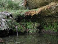
The waterfall and grotto is one of the highlights of the trail and features an abundance of fern.
The waypoint "Falls" marks the location of a picturesque grotto and waterfall that is well shielded from the Sun by the overhead vegetation and the steep canyon walls. An overhang in this grotto is further shielded by strange bulbs of rock jutting from above. Underneath the conditions resemble a cave more than an overhang.

Some of the formations in the overhangs appear to be "live". In other words they are geologically active and are being formed and transformed, most likely by the flow of mineral-bearing spring water. Touching some of the surfaces can damage them, so please enjoy them via sight alone.

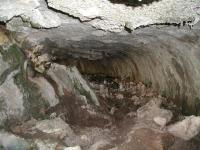
The rock overhang at the grotto waterfall is so sheltered from the elements that the underside looks more like a cave than an overhang.
The trail crosses the creek which carved the valley several times, but in each case a small bridge, or a set of stepping stones provided easy fording of the stream. While some elevation gain exists near the turnaround point of the hike, for the most part the trail is relatively flat.

The valley narrows slightly just before reaching the San Gabriel River. Upon opening up to the river the trail continues to the right up a series of steep rock steps. The views of the river below from atop the bluff are beautiful and people who live in the are use the spot often, as evidence by the family picnicking near the cliff during our visit. The land on the bluff appears to be a lot that is for sale, so this particular part of the trail may not be accessible in the future.

The view overlooking the river was a fitting spot at which to rest and reflect on some of the interesting landscapes to be found in the Georgetown area. This short trail did not disappoint with its twisted and intriguing rock formations. In all we hiked one mile in about 30 minutes, which included a bit of time finding the geocache hidden near the path.

Photos
Trail View
The trail surface consists mostly of mulch and its boundaries well marked with rocks or branches. (Photo by Austin Explorer)
Dripping Rock
The rock formations along the trail are fascinating. The rock here almost looks like it's dripping down. (Photo by Austin Explorer)
Stone Bench
This interesting stone bench resides along the trail not far from the overlook turnaround point. (Photo by Austin Explorer)
Ferns
Ferns love the valley's shade and relative moisture to what's available just a few hundred feet away on higher ground. (Photo by Austin Explorer)
Another Trail View
Despite the sometime vertical rock walls that define the valley, the trail manages to gain or loose little elevation until the turnaround point. (Photo by Austin Explorer)
San Gabriel River
The turnaround point of the hike overlooks the North Fork of the San Gabriel River. (Photo by Austin Explorer)
Log Entries
Hiked to car from trail.
By khdesigns on 10/18/2014
Rating: 2stars Difficulty: 1point5stars Solitude: 3stars
Distance: 1.00 Mile Duration: N/A
Not Public
By JCoffee on 5/13/2012
Rating: halfstar Difficulty: halfstar Solitude: halfstar
Distance: N/A Duration: N/A

There is a sign posted: "Private, No Trespassing, Violators Will Be Prosecuted"

By fiftyandfat on 1/2/2011
Rating: 3point5stars Difficulty: 2stars Solitude: 3stars
Distance: 1.00 Mile Duration: N/A

First of 50 hikes I am going to make in my 50th year!

Nice Surprise for the 4th of July
By Rajun Cajun on 7/4/2010
Rating: 2stars Difficulty: 2stars Solitude: 3stars
Distance: 2.00 Miles Duration: N/A

We didn't really know what to expect about this  trip but only had limited time so I thought it would be fun to try out this little trail. Took the family and another family for a morning hike on this 4th of July.  It was the first time out for my friend and his little one's (7 & 9) so the the bugs and frogs were an instant attraction.  Hiked to the river and everybody jumped in because the water was flowing and only about six inches deep. Another great feature were the caves along thte way and they had some stalagtites!Great little trail tucked away in an up and coming neighborhood. Remember that at the begenning of the trial is kinda in peoples back yards so try to respect their rights to privacy.

By cmbarrick on 5/31/2010
Rating: 4stars Difficulty: 2stars Solitude: 2stars
Distance: 1.00 Mile Duration: N/A
Nice surprise.
By texaskdog on 5/31/2010
Rating: 3stars Difficulty: 2stars Solitude: 4stars
Distance: 1.00 Mile Duration: N/A

This was a nice surprise!  A deer kept running from us further back down the creek both directions.  Several large birds were back there.  Would have been nicer if the water was running but still easily gets a 3.  Expected it to connected with the long San Gabriel bike trail but it never does (may be across the river by that point).   Would get a 5 for solitude but a few houses are visible up above (but they are really nice).  When you are finished, take a left on Booty (the road you came in on) until it ends, you'll be just below the dam and there is the San Gabriel bike trail to Georgetown to the left and another path thru the woods to the right that make hook up with the Goodwater on the North side of Lake Georgetown.  FYI Booty changes names many times as it passes the airport and 35 but it is a shortcut to Berry Springs Park.

nice little hike
By toobsox on 1/15/2007
Rating: 3stars Difficulty: 1star Solitude: 2stars
Distance: 2.00 Miles Duration: 1 minute
Nice, short hike. Best part is the view of San Gabriel at the end.
Perfect quiet little trail
By Tim0325 on 10/16/2005
Rating: 4stars Difficulty: 1star Solitude: 4stars
Distance: 1.00 Mile Duration: N/A
Hiked it today - 80 degrees out, but cool along the creek in this green canyon.
My back yard
By djolly on 6/30/2004
Rating: N/A Difficulty: 2point5stars Solitude: 4point5stars
Distance: 2.00 Miles Duration: N/A
I was scanning good hiking sites on the web, and the hill view picture stood out, I live right across the bank on River Rd.. In that same picture there is a rock formation and at the top we installed some climbing bolts, it is an excellent climbing spot. and actually if you cross the river and hike up stream there are some better hiking spots as well as a small cave and if you keep going you'll find some natural springs and then lake georgetown. that whole area is awesome I've been hiking it for 15 years. just please pick up you trash when you go
Nice easy quick getaway.
By moore9ksucats on 3/18/2004
Rating: N/A Difficulty: 1star Solitude: 3stars
Distance: 1.00 Mile Duration: N/A
Fantasic place for a leasurely stroll and some quiet meditation.

Only showing last 10 log entries. View All Log Entries

Recommended Item
Recommended Item Austin (Lone Star Guide to Austin)
Richard Zelade
List Price: $15.95 Your price: $14.47 Buy Now
Lonely Planet Pocket Austin is your passport to the most relevant, up-to-date advice on what to see and skip, and what hidden discoveries await you. Jump into the icy waters of Barton Springs Pool for instant relief when the heat gets too much, catch a local band at the Continental Club or one of the hundreds of live-music venues around town, or watch the nightly exodus of America's largest urban bat colony during summer, under the Congress Avenue Bridge; at all with your trusted travel companion. Get to the heart of the best of Austin and begin your journey now!