Getting there: From Austin head east on Highway 71. Proceed into La Grange and turn right onto State Highway 77 and head south. Turn right onto Spur 92 and look for the park headquarters and parking area on the right. The trail starts near the park headquarters building.
The Hikes: The History Trail begins at the "Trailhead" waypoint that's near the park headquarters building. From the start of the hike one can easily see the monument to the fallen soldiers of the Dawson expedition. Head in that direction to complete the loop
in a clockwise direction.
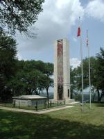
This monument and crypt was erected in the 1930's to honor the fallen soldiers of a Republic of Texas military expedition.
The monument at the waypoint "Monument" provides the first half of the name of the park. It was erected in 1848 to serve as the final resting place for the soldiers who were killed during the Dawson expedition in 1842. A group of milita from Fayette County ventured south to try and
evict the Mexican Army from San Antonio six years after Texas had won its independence. Some of these soldiers were killed outside of San Antonio and some in Mexico as a group of soldiers volunteered to venture farther south in retaliation. They were captured and forced to draw lots
in the infamous "black bean" incident by which Santa Anna ordered the execution of 17 soldiers.
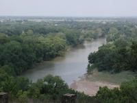
The view from the top of the ridge is stunning. The Colorado River and city of La Grange sit 150 feet below.
The trail continues in back of the monument and quickly shows a terrific view of the Colorado River and the town of La Grange. The bluff on which the park is perched sits about 150 feet above the river below.
The trail follows the ridge to the east and soon comes upon the back of the Kreische family home. What you see here is not the front of the house, but the back. The main door leads to the second story, not the first, as you'll see later. This spot also includes another scenic overlook, providing another view of the city below
Soon after passing by the Kreische family home the trail turns to the right and then back as it begins to return to the trailhead. But there's a short detour to the left soon after the trail turns. This small spur travels slightly downhill to a platform that overlooks the Kreische
Brewery in the valley below.
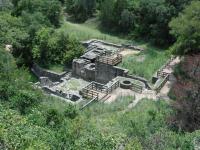
The Brewery overlook provides a bird's eye view of the ruins of Kreische's business.
On our hike we ran into a couple of Spiny Lizards in the oak tree by the Brewery overlook spur. The territorial lizards don't back down very easily and decided to stare us down for a long period of time rather than scurry away. We saw a couple of other Spiny Lizards on our day at
the park and all of them stood their ground as though they were Godzilla instead of tiny reptiles.
At the waypoint "Kreische Home" we finally come across the front of the Kreische family home. As you stand at the front of the house keep in mind that much of the original lumber is still in place. This house served as a home to Kreische's children up to 1952. A couple of support structures can be found in front of the house including a stone smokehouse and a small wooden barn.
From this point the trail continues back to the park headquarters and completes the .7 mile loop. In all it took us one hour to complete the hike, read the historic markers and enjoy the stunning views.