[ Log In ] or [ Register ]
Texas Hiking

Buescher State Park

Trail (4.19)
(2.73) (4.18)
7.00 Miles 700 Feet
N/A No
Yes No
$3.00 More Info
Smithville Bastrop
Take Action Bookmark and Share

Getting there: From Austin head east on Highway 71 and drive past Bastrop toward Smithville. Turn left north of Smithville and head north on FM 153 for half a mile and turn left into the park. After paying for park entrance drive past the ranger station and turn right onto Park Road 1E. Drive around the small lake and look for the brown signs that mark the trailhead on the right. Parking is on the opposite side of the road.

The Hikes: Buescher State Park is a sibling of the nearby Bastrop State Park. Despite its close proximity and the fact that it also features a portion of the Lost Pines the park tends to host fewer visitors. If you crave hiking solitude you can use this to your advantage.

The trail starts off at the waypoint "Trailhead" and heads in a northwest direction for about 1/3rd of a mile before coming to pipeline right of way. This pipeline right of way is none other than the Longhorn Pipeline that has been in the news as of late. During my hike the pipeline crews just so happened to be working in the area, though not immediately along the trail.

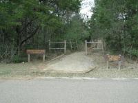
The trailhead resides at the back of the loop road that encircles the park lake.
Not wanting to give up the hike I continued to walk along the pipeline route and occassionally had to step over erosion control barriers. Off in the distance I could see some work being done on the pipeline even though it was Sunday. Thankfully after half a mile the trail proper continued again at the waypoint "Y-Right". After a short distance back into the forest I was able to leave the commotion behind me.

Buescher includes a portion of the mysterious Lost Pines.
The trail soon turns more to the north. Although it begins to come into contact with Park Road 1C this does not hamper solitude too much. Traffic along the road is light. On nice days bicyclists may outnumber drivers. The road connects Buescher State Park with its sister Bastrop State Park. The route is quite popular with cyclists.

Buescher State Park's shape somewhat resembles a gerrymandered Congressional district. One of the reasons for this can be found at the "Road Cross 1" waypoint. Here the trail crosses the entrance to the University of Texas cancer research facility. At some point in the past part of the park was set aside as a research campus. The remaining land snakes around this research park.

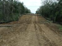
A half mile of the trail is along a pipeline right-of-way. During my hike this pipeline was under repairs, making for a less than natural experience.
To complete the full trail loop always choose the right fork in any split in the trail. Although Buescher shares many characteristics with its sibling park it does not include as many ponds, the Houston Toad's preferred mating grounds. However there is one pond along the trail visible at the waypoint "Pond".

Prior to my hike a strong storm had moved through the area and blown some trees down and weakened others. The quiet of the hike was shattered for a moment as one of the pines finally collapsed to the ground not too far off trail. Though the experience caused me to wonder about the structural integrity of some of the trees along the trail that I passed I realized that any danger was very remote and that my witnessing the event was in a sense a bit of luck.

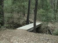
All creek crossings are easily done. Some include a small footbridge to make the crossing even easier.
Contrary to what the official trail map states the road crossing at "Road Cross 2" does not traverse a dirt road. That is now paved. However, the road appears to be still be quite lightly used and crossing is not a problem.

The Lost Pines are one of the most interesting hiking areas in Central Texas.
Once across the road the most interesting portion of the hike begins. The terrain on the northwestern side of the park is more rugged and heavily forested. In some places the falling pine needles are so numerous that they hang in clumps like moss on smaller trees and bushes. The steeper terrain is cut by a number of small creeks in this portion of the park. The trail crosses many of the streams, most of which will be dry except during rains.

The rougher terrain, denser foliage and fewer park visitors probably account for the group of deer that I saw on the back end of the trail. I crouched down and remained silent trying to observe them for as long as possible. Playful screams from bicyclists on Park Road 1C caused them to make a hasty retreat farther away from the road.

Strong winds had knocked many trees down, including some across the trail. During my hike I heard another crash down not too far away.
The trail crosses Park Road 1C at the "Road Cross 3" waypoint and soon thereafter turns to the south. I turned right at the waypoint "T-Right" in order to extend the outer loop. Going left will rejoin the trail along the park road sooner. Much of the elevation gain is found in this portion of the hike. The hiker is propelled up and down ridges until the trail meets up again with Park Road 1C and very soon thereafter with the return route back to the trailhead.

During my hike on a pleasant Sunday I did not see one single other hiker on the trail. The only sign that anyone else was even out there was a wildflower book that I picked up on the way back to the trailhead, which I left at the lost and found desk of the ranger station. The book was not there on the way out, so someone MUST have been out there with me. Still, though I did not see other hikers I did see pipeline construction workers off in the distance and a few drivers and bicyclists along Park Road 1C. This hike provides ample opportunity for getting away from the crowds found on many area trails.


Photos

No photos have been uploaded for this location.

Log Entries

great hike
User: stefminus - 4/7/2010  [View Log Page]
Rating: Difficulty: Solitude:
Distance: 7.70 Miles Duration: 3 hours, 15 minutes

i just did this whole thing on sunday evening (4/4/07) and it was a pleasant surprise. i wish i had a map of it beforehand as that would have been a great help. now that i have seen it, i finally understand how i crossed the road 3 times (i don't count the first crossing on the map because it crosses at an intersection near the cancer research facility). the part at the beginning with the pipelines is now completely covered in grass with a trail eroded down into it. there's a ton of crashed trees along the trail, some of which are really big. the whole thing is pretty easy on your feet until the middle part where it starts circling around. at that point there's a lot of downhill stuff that can be kinda rough on your ankles if you're not careful. at this point i saw a gigantic buck off in the trees but he took off before i could snap a photo. i saw a few cardinals and a rabbit, and heard some frogs cry out as i approached them, but that was about it for wildlife. not knowing the trail map, i was getting worried until i got back to the part where you start retracing your steps on the trail. it was getting dark and i had a 13yr old aussie shepherd with me who was starting to quit on me. i had to do the pipeline stretch and the last part that leads back to the park in the total dark since i thought i would get back before dark. luckily that part of the trail is wide and pretty obvious where you're supposed to go. i recommend this thing if you want a fairly easy - but long - walk in the woods by yourself (or with immediate company). i didn't see anyone else on a nice sunday evening.

Cedar Tree Houes Hike, With my Sisters
User: Miles - 2/28/2009  [View Log Page]
Rating: Difficulty: Solitude:
Distance: 6.50 Miles Duration: 2 hours, 30 minutes

We went out to find a couple of caches. Eight of us started the hike. Only three of us made it all the way. Sun shine, but cold and windy. Got back to the cabin. to find a wild fire had started. Had to evacuate the cabin about 1:30 in the afternoon. We'll be back for a full weekend of fun and adventure!

Nice and Shady!!
User: pongob - 9/21/2008  [View Log Page]
Rating: Difficulty: Solitude:
Distance: 7.70 Miles Duration: 3 hours, 30 minutes

Went on this hike with my husband on a very warm September day.  We're slow hikers, more like strollers really and stopped several times just to take in the sights and sounds of the woods.  Very nice.  We saw 4 deer and only 1 other person on the entire trail.  Great walk in the woods and not rocky at all!

User: kernel - 12/27/2007  [View Log Page]
Rating: Difficulty: Solitude:
Distance: 7.00 Miles Duration: 2 hours, 30 minutes

Cold morning (freezing) but quite a few deer and birds out and very peaceful.

Short Hike
User: Miles - 1/11/2007  [View Log Page]
Rating: Difficulty: Solitude:
Distance: 1.00 Mile Duration: 1 minute
Hit the trail to find the geocaches today.
There are better trails
User: James273 - 3/20/2006  [View Log Page]
Rating: Difficulty: Solitude:
Distance: 7.40 Miles Duration: N/A
This trail doesn't offer a lot. Towards the end it gets a bit more exciting. It is an easy trail and children can enjoy it.
Super fun, easy , great terrain, no people
User: Soonhorn - 11/27/2005  [View Log Page]
Rating: Difficulty: Solitude:
Distance: 7.00 Miles Duration: N/A
Cushy pine needles soft under your feet with a top canopy of pines that shade most of the trail. Look at the baby pines along the trail and listen to the quiet. The trail is easy to follow if you get a map at the ranger station. The pipeline that I read such bad reviews about is great! It is now just an open stretch on the trail. We took the kids (17 and 12) on this one. It turned out to be the easiest hike we have taken. Hardly any people and it is super cool country. So different than the rocky trails we are used to. The park is great too! Don't miss going to the dam and goofing around there at the lake. I am taking my fishing pole next time! Be sure to stop in Bastrop for some good mexican food on the way home.
Pretty cool hike on a HOT day
User: Shylock and Fiona - 9/19/2004  [View Log Page]
Rating: N/A Difficulty: Solitude:
Distance: 7.00 Miles Duration: N/A
We hated the pipeline area. What I couldn't figure out is why they didn't put a trail in the woods that parallels the pipeline? It was hot and exposed and for no good reason. The trail became something very special after the second road crossing, though. This hike is worth doing for that section alone. Saw only one other couple the whole day.
Nice hike on a rainy 4th of July morning
User: kbohn365 - 7/4/2003  [View Log Page]
Rating: N/A Difficulty: Solitude:
Distance: 7.00 Miles Duration: N/A
Drove in from NW Austin with my dog, LucyFur, for an early morning hike on the 4th of July. It was pouring -- we waited for an hour hoping the rain would stop, but decided to go for it. Very secluded and quiet. Enjoyed the forest. I plan to use this hike for backpacking practice in the fall. The trail head is right across the street from some walk-in camp sites. You can backpack the loop and camp for the night. Then backpack the loop again the next day.
User: JClair - 5/21/2002  [View Log Page]
Rating: N/A Difficulty: Solitude:
Distance: 7.00 Miles Duration: N/A
Enjoyed this hike alot.....more than Bastrop........solitude is just great......saw lots of wildlife and it was just fun...give it a go.

Only showing last 10 log entries. View All Log Entries

Recommended Item

Recommended Item Official Guide to Texas State Parks (Learn About Texas)
by Laurence Parent
List Price: $21.95 Our price: $2.00 Buy Now
Whether you enjoy looking at scenic landscapes, touring historical sites, camping, fishing, hiking, backpacking, swimming, boating, horseback riding, rock climbing, or almost any other outdoor recreation, there's a state park in Texas where you can pursue your pleasure. From the Panhandle to the Rio Grande Valley, the Pineywoods to the Big Bend, some 125 state parks offer you a natural escape from fast-lane living. This book is the only official and complete guide to the state parks of Texas. Loaded with accurate, up-to-date information from the Texas Parks and Wildlife Department, it describes the attractions of each park and gives details--including a locator map--about camping and lodging facilities, types of recreation offered, and addresses and phone numbers for more information. To assist you in planning trips, the parks are grouped into seven geographic regions--Big Bend Country, Gulf Coast, Hill Country, Panhandle Plains, Pineywoods, Prairies and Lakes, and the South Texas Plains. With gorgeous color photographs and an inviting text, Laurence Parent depicts the natural features and attractions of each region. So if you want to watch the sunset over Enchanted Rock, fish in the surf on the beach at Galveston, or listen for a ghostly bugle among the ruins of Fort Lancaster, let this book be your complete guide. Don't take a trip in Texas without it.