Getting there: Pace Bend Park takes up most of Pace Bend, one of the
many folds of land around which Lake Travis flows. From the intersection of RR 620 and
Hwy. 71, take Hwy. 71 west 11 miles to RR 2322 (a.k.a Pace Bend Park Road). Turn right
on RR 2322 and travel 4.6 miles to the park entrance. From there, proceed straight on
the main park loop road and park at the intersection of the loop road and the feeder road
that continues north to the tip of Pace Bend. There's not much in the way of parking,
though this spot provides the most parking at a trailhead and we did not have any other
vehicle with which to contend.
The Hike: Pace Bend Park juts into Lake Travis providing lots of land with
a premium on lake access. Much of the park is dedicated to getting down to the water and
hiking seems to be an afterthought. In some respect this is a blessing since it means that
very little of the park away from the shoreline has any development or visitors.
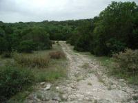
-small.jpg)
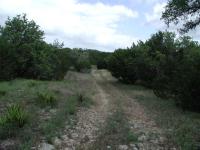
Most of the trail is wide and easy to follow.
We started out hike at the northernmost access point to the trails at the waypoint marked
"Trailhead". The trail is mostly of the "jeep trail" variety and is thus easy to follow.
Several side trails, many of them smaller than the main trail that we followed, meander off
in different directions. To assist you on some of the less obvious trail crossings we've
included instructional waypoints, such as "Y-Right" and "Y-Left", which indicates a fork in
the road and the direction that we took.
With one exception, the trails were devoid of people.
The trail is easy to follow and usually provides wide berth between the trees and shrubs,
you you have to be careful in Pace Bend not from what's in the trees, but what's between
them. On our trip we encountered numerous spider webs that completely spanned the trail.
A dense center of several feet in diameter were held in place by support strands that
extended the structure to outwards of 10-15 feet. Some of the webs contained spiders,
waiting for dinner to drop in. A big web can hold a big spider, which these were. We
could not identify the species of the spiders (something we need to work on) but can
report that their diameter with legs were 2-3 inches across.
We got pretty good at seeing the web before running into them as we progressed along the
trail. Sometimes we just walked around them, but occassionally we had to use a stick to
clear the path. Sometimes it's a choice between tearing down a spider's web and
trampling on some of the vegetation just off the trail.
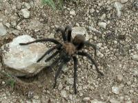
One of the many spiders we saw. Yes, this Tarantula is THAT big.
The web spiders were not the only ones visible on the trail. Crossing our path on this
trip was a 5-6 inch in diameter Tarantula which you can see pictured on this page. It was the
biggest spider that we had seen in the wild.
Just past the waypoint marked "Y-Right2" the trail comes to a "T" section. We turned to
the right as that seemed to offer us the greatest opportunity to extend the hike longer.
Further south at the waypoint marked "Side Trail" there is yet another excursion that we
mean to investigate in the future. Chances are that this trail joins up with the "Pack
Trail" drawn out on the topo map to the west of our trail.
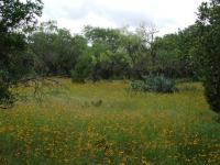
A field of Sunflowers and Prickly Pears.
We ran into something unexpected at the waypoint "Fenced Area". A small patch of land is
fenced off with what appears to be a water tank and building inside. Nothing else exists
around here and the only roads leading to it are the jeep trails on which we are hiking.
It does not appear to be abandoned and seems like it should be in working order. On our
topo map you can see the circle that we made around the perimeter of the fence during
the day.
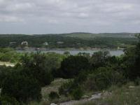
One of the few views of Lake Travis available on the trail.
We went clockwise around the fenced area and then found a trail that continued to the
south east. This trail proceeds down a small creek valley towards our second trailhead
of the day. At "Road1" we ran into the paved road that circles the park. We turned back
and then took another spur that headed southwest towards yet another trailhead at "Road2".
Along the way we experienced some rougher trails that were more overgrown than the other
trails.
The slopes on the trail are not too severe, but after 5 miles even small climbs start to get tiring.
At this point we decided to head back toward our trailhead and call it a day. On the
way back we investigated the western side of the fenced area and found just about the only
decent lake view to be found on the hike. At "Scenic View" the sparser foliage and steeper
incline provides a nice view of the lake and some of the large houses that line the shore
on the opposite bank. There are plenty of signs of additional, smaller trails that start
from this point and head to the north and south along the ridge. This might provide many
more lake views than we were afforded on our trip.
When we returned to the large "T" in the road near "Y-Right2" we continued to the east to
see where the trail ended. At "Road3" we found yet another trailhead than runs right into
the main park road.
Pace Bend hiking is not supported by an intensive support program that includes convenient
parking, detailed park tails maps and guided tours. For some, that may make this park all
the more interesting and challenging. During our hike of 6 miles and 4 hours we saw only
other group, a man and two children on the entire trail. For solitude, Pace Bend is hard
to beat.