Good Water Trail

Trail
16.50 Miles
N/A
N/A
3point5stars (3.85)84
2point5stars (2.77)
3point5stars (3.51)
N/A
Yes
Yes
No
Georgetown
Williamson
More Info

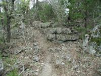
The trail near the trailhead is composed of gravel. That soon changes in about a quarter mile.
Getting there: To get there head north on I-35 into Georgetown and turn left onto Highway 29 and head west. Turn right onto D.B. Wood Road and head north into Cedar Breaks Park. Obtain a trail map at the park entrance.

The Hike: One of the longest trails in the Hillcountry area is also one of the most overlooked. The Goodwater Trail snakes around Lake Georgetown and almost completely encircles it. With several trailheads to choose from this hike provides ample opportunities for short day hikes or even a multi-day circumnavigation.

A rainy month prior to my hike meant that the falls at Crockett Gardens were gushing more than usual.
The most common starting point for a hike along Lake Georgetown is at Cedar Breaks Park, at the southeastern corner of the lake. Here the trail starts off on a well maintained surface of crushed stone, but within a quarter mile turns rocky and rough as it approaches the lake shore. Some of the best views of the lake occur near mile marker 1 on the trail and thereafter.

Along the trail there are numerous signs of the people who used to live in the area before the reservoir was filled in. At about the 2.5 mile mark on the trail lies Crockett Springs, sometimes referred to as Crockett Gardens. A natural spring feeds a small water fall. This little oasis provided water for a vegetable garden, that included the first strawberries grown in Williamson County. The remains of several structures can still be seen here, including a corral and a spring house. A history of the land that is now flooded by or adjacent to Lake Georgetown is available on the US Army Corps of Engineers web site.

Lake Georgetown as seen from a point along the trail. Early enough in the day before the boaters showed up.
The roughest, and perhaps most interesting, segment of the trail occurs roughly between mile markers 5 and 7. Here the trail cuts through rough terrain, sometimes passing through gaps between immense limestone boulders over six feet high. Thick clusters of cactus and Cedar also dot the area, sometimes partially overhanging the trail itself.

The terrain between mile 5 and 6 may be the most interesting. The trail gets very rough and ventures through numerous rock fields.
Between Mile Marker 7 and the Tejas Camp trailhead (near Mile Marker 11) the trail overall becomes flatter than the preceding miles. But between the long segments that cross lakeside plains there are occasional forays uphill into the Cedar and Oaks.

At Tejas Camp the trail crosses onto the northern shore of Lake Georgetown via a small bridge shared with light auto traffic. The crossing here is short because the lake has tapered back into the shape and name of the North Fork of the San Gabriel River. On the north shore the trail heads east.

A view of the upper reaches of Lake Georgetown from the trail during a dry spell.
In general, the north shore's trails are the easier ones and this is particularly true of the trails on the northwest sector of the lake. The trail here consists of wide jeep trails and dirt roads on terrain that gently undulates for several miles before things get a bit rougher.

The trail as it edges a slope to the left and a plain leading to the lake on the right.
No more than a half mile beyond Tejas Camp the official trail paradoxically leaves the wider path for a single track through Cedar and cactus. I totally missed this fork in the trail on my original pass and caught it only my return back to Tejas Camp from where I started my day hike. There is no sign indicating this and the wider path parallels this one and will rejoin it a bit later. Proof that the official trail is the narrower path is validated by the appearance of mile marker 12.

The trail's gentle terrain changes drastically near mile marker 16 on the approach to Russell Park. It starts to look more like the south shore with rock outcroppings and boulders strewn about. The original end of the trail was at the 16.6 mile point in Russell Park and it's an uphill trek to get to the parking area there. The climb would be all the more challenging if you had tackled the trail in its entirety up to this point.

The area around Tejas Camp at mile marker 11 is a popular fishing spot.
Recent trail work by the Austin Ridge Riders and the International Mountain Bike Association has expanded the trail system beyond Russell Park and to practically encircle Lake Georgetown back to Cedar Breaks Park. I failed to find the continuation from the Russell Park trailhead, but I'm assured that it's there. I'll tackle that final segment on a later trip.

Looking back from the northshore to the southshore. Note the more rugged terrain on the other side of the lake.
Although popular with scouting groups for camping trips, the Good Water is not heavily used, particularly when venturing far from the established trailheads. What you will encounter on pleasant days is lots of boat traffic on the water. On one trip I even had to put up with a hovering helicopter on a sight-seeing trip.

Alternate trailheads exist at the end of West Lake Parkway (near Mile Marker 5), at Tejas Camp (Mile Marker 11 at the western-most tip of the lake) and at Russell Park (Mile Marker 16.5). Russell Park is closed from October 1 to March 31 every year, though the Corps of Engineers indicates that it's OK to park outside the park during this time, but at your own risk.

Bicycles are allowed on the trail, but only on the north shore of the lake according to official Corps of Engineers trail maps.

Photos
Tricky footing
It may not look all that treacherous, but picking your way over these pointy, holey rocks for hours takes its toll. (Photo by plectrudis)
Glorious emerald mound in winter
After the rains in late Dec 2015, the falls were brilliantly green and gushing with water. (Photo by plectrudis)
Goodwater Loop - jeep track from Tejas Park trailhead
The trail is much more comfortable in December--there's some fall color, and the grasshoppers are dead/dormant. (Photo by plectrudis)
San Gabriel River in Tejas Park - Goodwater Loop
Take the little foot trail to the left off of the main jeep track from the Tejas Park trailhead to reach the river. ~1.5 mi from trailhead. (Photo by plectrudis)
Nice view
The trail is full of views like this. (Photo by WarriorHistorian)
Find me if you can
Geocache marker I left well off the beaten path behind Crockett Gardens. (Photo by WarriorHistorian)
Very tall primitive fence
Tallest primitive fence I have seen, located just south of mile marker 3. (Photo by WarriorHistorian)
Old corral
Old corral wall still standing. (Photo by WarriorHistorian)
Old wall
I believe this was part of the original living quarters. (Photo by WarriorHistorian)
Springs crossing
Springs crossing (Photo by WarriorHistorian)
Shed ruins
Old ruins of a shed. (Photo by WarriorHistorian)
Crockett Garden Falls
Crockett Garden Falls (Photo by WarriorHistorian)

Only showing last 12 photos. View All Photos

Log Entries
Crockett Garden Falls the high point; lots of ankle twisters
By plectrudis on 1/2/2016
Rating: 3stars Difficulty: 2point5stars Solitude: 3point5stars
Distance: 9.40 Miles Duration: N/A

From the Cedar Breaks trailhead.

The best part of the hike was definitely the Crockett Gardens Fall.  Note that for the best view of the falls, you'll need to take a little side trip--follow the stone marker and take the path to the right.  It's less than a quarter-mile.  Everything else was grey and dreary and leafless, but the falls were this glorious mound of emerald, cascading with maidenhair ferns and crowned, implausibly, with a huge pool of elephant ears.  

The old farm ruins were pretty neat, too, and when you return to the main trail and climb up above the falls, there's this magical spot where the springs puddle before they trickle over the rock, and it's full of irises--would love to see them in bloom.

Cons: the trails are full of pointy, irregular, ankle-twisting rocks.("karst" maybe?). It's extra work to pick your way over this treacherous footing, and all the time you have to spend watching your feet really limits your sightseeing.  Picturesque, but a PAIN in the arse.  Unless you're a mountain goat, pack an ace bandage, just in case.

Also, the trail mile markers don't appear to begin counting until the trail hits the lake, which means you get an extra mile to and from the parking lot.  We meant to walk 7 miles (manageable), but because of the weird way the miles are counted, we accidentally ended up hiking 9.4 miles, which beat the stuffing out of me.

I'd do it again (especially when the irises are blooming), but probably only to the Crockett Gardens and back, so that it doesn't turn into a death march.

Tejas Park: Not sure I was actually on the trail
By plectrudis on 9/28/2015
Rating: 3point5stars Difficulty: 2stars Solitude: 5stars
Distance: 3.00 Miles Duration: N/A

This was my first hike on the S Gabriel trail, so I didn't really know what to expect.  I found the trailhead easily enough, but the trail was interrupted by a camping area, and I couldn't figure out where it picked back up.  There was a Jeep track leading off to the left, so I thought, what the heck, and followed it. 

Very pretty views from the Jeep track--the river sweeps around in an arc to the left; on the right is a small prairie, and in the distance in front of you is a nice line of hills.  However, there is ZERO shade, so a fine hike for a Sept evening, but probably miserable on an Aug afternoon.

After about 3/4mile, there was a walking trail leading down to the river, so I took that and scarbbled around the riverbank until it turned sharply to the left.  It was pleasant and desolate--just me, an army of grasshoppers, and some kildeer making very melancholy calls.  Oh, and a lone kayaker, who must have spent as much time walking as paddling.

I'd do it again, but I'll probably try other sections of the trail first--hopefully, more clearly marked sections.


Great veiwes and awesome glimpse into history.
By WarriorHistorian on 2/1/2015
Rating: 5stars Difficulty: 2stars Solitude: 3stars
Distance: 8.00 Miles Duration: N/A

Hiked 4 miles in from the Cedar Breaks Park TH past Crockett Gardens. While Crockett Gardens was gorgeous and a great glimpse into history I was saddened to find that a large portion of the area, including where the springs flow out of the limestone cliffside and the old 3 walled structure, are fenced off and marked private property. The landowners have obstructed a large fence that causes a choke point on the trail. I'm absolutely dumbfounded that they would do this to prevent explorers from taking the whole area in especially since it's not easily accessible from the rest of their land due to a good size cliff wall. There was still much of the original structures that we could explore along with the falls. Highly recommend this trek to anyone who loves good views and history. Will return to explore further in the future. As always Id be happy to accompany fellow travelers, marksanderson23@icloud.com.

Bit off more than we could chew, almost...
By khdesigns on 10/18/2014
Rating: 4point5stars Difficulty: 2point5stars Solitude: 5stars
Distance: 10.00 Miles Duration: N/A

The plan was to finish off the final miles of the trail to complete the entire loop. We have been hiking/camping sections of the 26 miles for the last year. 

We parked one car at booty crossing park, then drove to russell park to our campsite and started hiking back to booty crossing to drive back to Russell park for the night. About 10 miles. 

We left Russell park and hiked to Jim Hogg to rest and eat lunch, also got in the lake to cool off a bit. This section was 3.5 miles give or take. The trail markings start to get confusing as in, non-existent around mile 23 through 26. It started getting late, the sun was setting and we still had a couple of miles to make it to Booty Crossing Park before the gate was locked for the night, along with our ride back to Russell! Eeek 

The last mile was basically a paved sidewalk and we jogged to get to our car, in the dark with headlamps. My husband waited at the gate while I ran to get the car. As I pulled up the guy was there to lock the gate.

The last two miles all I could think about was my bed. We were pretty worn out but WE DID IT! We hadn't set up camp before stepping off so we took it back to the casa for the night.

We camped at Russell Park the next weekend and did some short hikes.

Relaxing and enjoyable.

We live in Georgetown and love the trails around the lake. It's always an adventure. See you on the trails!


nice, but HOT
By Sunshinedog on 6/21/2014
Rating: 3point5stars Difficulty: 2point5stars Solitude: 2point5stars
Distance: 15.00 Miles Duration: N/A

I have done different sections at different times.  It is rough in spots, about first 2 miles in from TH you will run into hikers, walkers, runners in the early morning, but not many others after that.  The rocky parts at the beggining will kill you and your dogs feet.

After mile 2 there is about a mile of prairie opening that will bake your skin and brain-  I call it the death mile in the summer, but then you come the springs- even in the drought there is enough cold water trickle down the ferns to make life enjoyable again.

Tejas to Sawyer and back
By crocodile235 on 9/22/2013
Rating: 3stars Difficulty: 3stars Solitude: 4stars
Distance: 8.50 Miles Duration: N/A

I did Cedar Breaks to mile marker 3 and back last year (not as much solitude there), but this time I started at Tejas Camp and went to Sawyer Camp and back.  (Plus a detour down a jeep trail between mile markers 9 and 10 where I discovered a secluded camp site in some trees near a creek/drainage.)  It ended up being around 8.5 miles.

Tejas Camp looked pretty nice, a good quiet place to camp if you don't need amenities (like showers).  Depite it being a gorgeous, not-too-hot weekend, there was no one there.  The toilets are adequate and there's water.  Some of the camp sites are near one another, and others are more secluded.  Most were shaded.

Sawyer Camp, on the other hand, was a mess.  If they're not going to fix up the old toilet structure, they should just knock it down--it's an eyesore.  Several of the fire/grill pits were broken and/or overgrown with grasses and vines.  There was litter scattered around.  The one picnic table there was OK.  The lake level was low, and if you needed to go down to pump water, you'd have quite a trek.   I saw only one, maybe two camp sites that would be worth pitching a tent in, and that's being generous due to the lovely solitude.

The trail itself was pretty good.  Lots of varied terrain, switching from open fields to wooded sections to rocky outcroppings.  I only saw a couple of other people the whole time.  There were some sections where grasses have grown over rocks on the trail--it would be easy to twist an ankle or crash your bike here.

Diamond in the rough. 11 minutes form Austin CIty Limits
By jvmx on 6/22/2013
Rating: 4stars Difficulty: 2stars Solitude: 4stars
Distance: 22.00 Miles Duration: N/A

We dropped in at the Cedar Breaks trail head and waked the full south shore of the lake. 11 Miles out. 11 miles back.

We saw very few people the entire 24 hours. On a weekend where we could not get a reservation at any state park with 100 miles of Austin.

  • There is nothing at the Cedar Breaks trail head other than a tidy parking lot. No water. No Trash cans. Nothing.

  • The "map" they pass out at the gate is the same PDF that you get on the web. ( http://www.swf-wc.usace.army.mil/georgetown/images/gtwn%20images/images/HikingTrailCDW.pdf ) IF you are an orienteering person: forget it. Perhaps the USGS quads are available.

  • The trail is not well marked, but very easy to follow. Our only confusion was to turn off on the feed trails Cedar Hollow Camp and Sawyer Camp. There are rck sign structures to mark the trail junction, but the wooden part that told you what is going on has rotted away.

  •   Crocket Garden/ Knight Springs was nice and cool. Good spot to filter water. (mile 2.5 or so)

  • Cedar Hollow Camp was empty other that one group of campers: despite the fact it was a Saturday night in June. It looked very nice. There are no facilities or clean water there. We pumped lake water here to purify it. We did not stay here. It did look nice. There were some boaters who looked like they were about to do "Drive Up Camping"

  • Sawyer Camp (Mile 6.5 ?) was up the hill a bit form the lake. There was not a single person there. We got there about 5 PM on a summer saturday. So if you are looking for a get away: this could be it. Getting to the lake to get water was a bit of a scramble thru some medium thickets. Bothe Sawyer and Cedar Hollow have old abandoned outhouse facilities. These are so abandoned that they have neglected to even tear them down. They are not useful: if you are the kind of hiker who needs potty....

  • From mile 7 to 10 the grass grows in on the trail so Knee high socks or long pants are advised. (not to mention the waves of grasshoppers you will upset: it was like a biblical /plague but cool!)

  • Tejas Park Campground is the one at the extreme West end. Very nice facility: But it is a "Drive up and camp" place. Despite this we were the only one to stay the night. Its clean an the land around it is very nice. Lots of room if you have kids who want to run in the open meadow. There is a single water socket with running water and restrooms.

    NOTE: The old guy who care takes the Tejas facility is very nice: but I get the impression that he has to have the rules followed. This means make sure you print your reservation slip or have it on your iPhone.

    * You never get to far from the noises of boats, farms or highways. But you don't see too much of it.

    We will go back and probably do the north shore before summer is out.
By crocodile235 on 4/1/2013
Rating: 3stars Difficulty: 4stars Solitude: 3stars
Distance: 6.00 Miles Duration: N/A
By ValEpiscopo on 3/24/2013
Rating: 4point5stars Difficulty: 4stars Solitude: 4stars
Distance: 14.00 Miles Duration: 5 hours
Hiked Good Water Trail from trail head to Sawyer Creek Hollow and back.
Great escape from the city
By tarrains on 3/24/2012
Rating: 4point5stars Difficulty: 3point5stars Solitude: 4point5stars
Distance: 8.00 Miles Duration: N/A

We started off by a few fishing areas and hiked four miles around the bend, up and down a hill, and through meadows to a friends campsite. We swam some but freaked out when we saw a snake. We fished some but it wasn't a good time of day. The camp site was very secluded. We hiked back in a race to beat the sun. The hill was much harder on the quick return. This lake has interesting and has ever changing terrain, beautiful scenic overlooks, and very open but secluded campsites. Sorry I can't remember the names of the trails or campsites.

Only showing last 10 log entries. View All Log Entries

Recommended Item
Recommended Item Lone Star Travel Guide to the Texas Hill Country
Richard Zelade
List Price: $18.95 Your price: $18.95 Buy Now
This book brings the remarkable Hill Country of Texas home to the back roads traveler. Whether it’s wildflowers you’re drawn to, or dude ranches, natural areas, historic sites, or quaint Texas towns redolent of history, this is your passport to an experience like no other. Backroads of the Texas Hill Country introduces travelers and armchair tourists alike to the emerging wine country of the Lone Star State, the meticulously preserved culture of East European immigrants, the “cowboy capital of the world” (Bandera), and the childhood home of LBJ at Johnson City. Follow this irresistible guide into the Hill Country, and find yourself deep in the heart of Texas.