Getting there: From south MoPac, take the Loop 360 exit and head east. The first light includes a left turn lane which leads you into a parking lot for the office building next to the trail entrance. Try to park as far to the left, close to the greenbelt entrance as possible.
The Hike:
The start of the trail is marked on the map with the waypoint labeled "Trail Head".
Here you'll find a large sign with a map of the entire Greenbelt.
The trails starts off by heading south west then west under MoPac and Hwy
360. The going here is fairly easy. As you can see from the topo map,
it's fairly dated. It does not show MoPac South crossing Barton Creek. Trust
us, it does.
The next waypoint on the trail is actually something that we explored on our
way back to the start. There is a very rocky stream bed that leads into a small
valley with a beautiful rockfall crevice on the face of the sheer wall to the
right. It looks like layers of rock just collapsed and created a slanted ledge
on which to perch. Unfortunately that spot was taken by a couple of other hikers
when we passed by, so we'll have to revisit some other time.
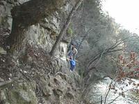
Chain crossing
The trail is fairly easy to navigate, with the exception of a few areas,
including the very narrow foothold that includes a chain drilled into the rock
to add extra support. It's not too scary though. We saw kids go by there and
dogs just ran across like there was no danger at all.
The main upper Barton Creek trail crosses the creek at Twin Falls. This is
a popular gathering place for folks hitting the trail from either direction, so
it can get rather crowded on nice days, as you can see from our photo.
Nevertheless, it's a fine place to take a rest and have a snack. If you work your
way a little downstream you can find a few nice rocks to sit on and listen to
the water. Most folks seem to be interested in getting their feet wet at the
falls themselves.
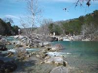
Twin Falls
On our trip this day we decided to stay on this side of the creek and take the
less travelled route that we were told led to some springs. So we continued and
came to a water rapids we've marked as "Bank Falls" on the map. More rapids
than falls the area is notable for being much less crowded than Twin Falls. It
also includes a relatively wide bank of well rounded stones and even a small grassy
bank. If you'd like to listen to water rapids but not hear as many people, this
might be a good place to go.
The waypoint marked cave is really just an impression in the rock face. But,
it makes for a fine place to stop and eat, which we did. The rock layers provide
natural seating and you get a good view of everyone on the trail.
The trail crossed several streams that feed into Barton Creek. But none of them
seem as interesting to us as the stream marked with "Slant Rock". This stream bed
is composed of layers of rock that angled relative to overall ground and the
light layer of rock is held up by a darker layer. As the light layered rock
cracks it gives the distinct impression of a concrete slab breaking up.
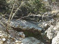
Slant Rock stream bed.
The waypoint marked "Spring" is the first of four springs that we found on
this day. But you'll be rewarded with a nicer set of springs if you continue
onward. When you get to "Twin Springs" you've reached the highlight of the hike.
Two springs sprout about 5 feet apart and join in a small stream leading to the
creek. The area immediately around the spring streams is teaming with small
green plants. At this point, you're close to the end of the trail. Near the
end you'll come across another spring, though we could not see it so much as
hear it and see the stream of water working it's way to Barton Creek. The
trail really starts to narrow and very soon will end in foliage. Time to turn
back.
On the way back we spent a little time picking up trash that others left
behind. In the end we collected a grocery bag full without exerting too much
effort. As always, take all of your trash with you when hiking, but also take
a little time to pick up a little extra. If we all did that we'd see no trash
on the trails.