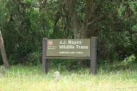
The J. J. Mayes Wildlife Trace was not my final hiking destination, but happened to be along the way so I sought to find it. Finding this place or the trail is not very easy since there are no road signs leading you there.
If you've read some of my earlier logs, you know that poor signage is one of my pet peeves. It makes absolutely no sense to me why someone would go through all the time, money and effort to make a trail, then not post a couple of helpful signs to those visiting the trail. It would not cost very much money and it would go a long way to minimizing confusion.
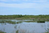
Let me explain how to find this obscure place. If you are travelling on I-10 East, you want to get off on Exit 805. The exit sign will simply say "Turnaround". Once you exit the freeway onto the service road, look for it on the right hand side of the road before you turnaround underneath the I-10 bridge over the Trinity River. If you miss this exit, cross the Trinity River bridge and see the Trinity River Island Recreation Area, you have gone too far and will need to turn around.
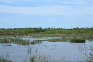
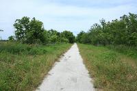
OK, having found the elusive J. J. Mayes Wildlife Trace, my next challenge was finding the trail. You enter the Trace on a dirt road which goes across some coastal wetlands for a few miles before it dead-ends and you must turnaround. Essentially, there is one main road in and out of this place. There is no visitor's center, no trail map, no information booth or kiosk, no employees you can ask... nothing! It's just a big, uninhabited expanse of land set aside for the wildlife.
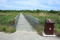
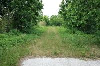
Along this main road, there are two, small parking areas with wooden boardwalks that lead to the Trinity River. I thought perhaps this might be the trail, so I walked down the southern-most boardwalk and asked some guys that were fishing if they knew where the trail was. They had no idea, but I was pleased to see there was an asphalt walkway leading to the other (northern) boardwalk, parallel to the river. When I got to the next boardwalk, I noticed an overgrown grassy path paralleling the river but it looked like an unmaintained service road. There were no trail signs, however, so I disregarded it and completed the loop back to my car.
Upon returning from my trip, I see that this overgrown grassy service road apparently was the mysterious Trinity River Trail. So, my .GPX file does not show the Trinity River Trail, but I hiked right next to it! Next time I am in this area, I will have to make it a point to hike the actual trail.
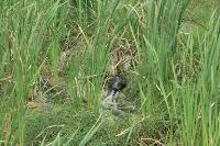
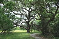
In closing, let me say that this is a good birdwatching destination. I saw numerous birds and several beavers. I had no ideas beavers lived in this type of habitat! Also, near the entrance there is a small parking lot. There is no sign indicating what it is for, but there is a narrow asphalt footpath that takes you to some picnic spots hidden away in the trees. There are some of the most magnificent oak trees in this picnic area, many of them fully mature and probably 50-100 years old or more. Definitely a must-see if you're in the area.
Even though this Trace sits right off busy Interstate-10, you experience a great deal of solitude as this place is virtually devoid of people.