Color Coded Trails In Memorial Park

Mountain Bike Obstacles
Obstacles like this were placed at various points to make the trails challenging for bikers.
User: Blaze - 2/26/2013

Location: Memorial Park

Rating: 2point5stars
Difficulty: 1point5stars  Solitude: 2stars
Miles Hiked: 9.50 Miles  Elapsed Time: 3 hours, 10 minutes

Comments:

Memorial Park is a very large city park "inside the loop" in West Houston.  It offers many amenities, too numerous to list here.  I would, however, like to try and give an overview of the trails in the park and to put some of the previous log entries into perspective.

First, there are jogging trails.  Lots of them.  The most popular seems to be the Seymour Lieberman Exercise Trail, which is a long (2.93 mile) loop that goes around the Memorial Park Golf Course.  It is a wide gravel trail and lots of people jog there.  This is the trail that texasgrape describes in his/her log entry on 10/4/2003.

In addition to the Seymour Lieberman Exercise Trail, there are other linear trails that run throughout the park.  I estimate these to be approximately 3.5 miles in total length, but that's a pure guess.

Second, there are hiking/biking trails.  Lots of them.  One cluster on the south side of Memorial Drive is a "tangled mess" of color coded trails.  The Purple Trail is basically a perimeter trail that can be hiked all the way around, but bikers are not allowed on the back stretch near Buffalo Bayou.  Within the perimeter defined by the Purple Trail, there are Red, Orange, Yellow and Blue Trails that run throughout the wooded area and along creek beds.  These are the trails that are described in wesley's log on 4/23/2006.  I estimate the total length of the Purple, Red, Orange, Yellow and Blue Trails to be approximately 7 miles (6 of which can be hiked/biked, and 1 mile of the Purple Trail which can only be hiked).

In addition, there is a Green Trail.  It is separate from the "tangled mess" and the trailhead is fairly difficult to find.  I estimate the length of that trail to be approximately 1.5 miles, but it starts at one point along Memorial Drive and ends at a different point along Memorial Drive about a mile down the road.  So, it's about a 2.5 mile loop.  I am speculating, but based on the distance this may have been the hike that korinne1229 logged on 8/1/2010.  Then again, she may have just hiked a portion of the "tangled mess".

Finally, the Houston Arboretum & Nature Center calls Memorial Park home at there is another "tangled mess" of trails there.  I will discuss those trails when I log my hike at that location since this website treats it as a separate location.

OK, now that I've described the layout of Memorial Park, the rest of this log describes my hike of the color coded trails only.  Future hikes of the other trails will be logged separately.

When you first drive into the park, after you pass under the bridge, you can bear right onto Picnic Drive.  There is a parking lot on the right hand side of the road, adjacent to the railroad track that runs north-south through the park.  If you park there, you can catch the Purple Trail.  It runs south along the railroad track under the high voltage power lines and, if you're lucky, you'll see the train pass by.  Just before you get to Buffalo Bayou, the trail turns left (east).  This part of the Purple Trail can only be hiked.  Bikes are not allowed.  The trail is fairly wide, but it does get constricted in places, especially in the section where the trail turns left again (north) as it heads back in.

As I mentioned in my overview, there are other color coded trails (red, orange, yellow and blue) that wind and wiggle throughout the interior of the perimeter defined by the Purple Trail.  These trails are much more scenic and fun to hike, but beware of bikers.  There are a lot of blind corners, so hike defensively since there won't be a lot of reaction time.

The Green Trail is a separate trail and the one I liked the least, primarily because it offers very little solitude.  At times, it is only 50 yards from Memorial Drive, which is a busy road so you constantly hear the sound of cars roaring by.  There are places where the trail heads back into the woods and gives you a little more solitude, but not for long.

For all the aforementioned trails, the signage is very good.  Display maps and direction markers are placed at key intersections throughout the park so you will always know where you are.  Sadly, some of the display maps and direction markers have been damaged or vandalized with graffiti, but most of them are in good condition.

In summary, I recommend the color coded trails as a place to hike.  It is in a very busy part of Houston, but at times you don't even realize you're in the city.  It's a nice escape and "nature break" if you don't want to drive out of the city.  If you go on a weekend, holiday or at a time when school/work is out, then watch out for bikers.


Log Photos
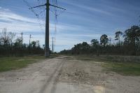
Trailhead - Purple Trail
Train
Detour And See Buffalo Bayou
Color Coded Trail Map
Centipede
Fern
Forest Within A Forest
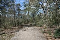
View Of The Trail
Another View Of The Trail
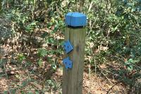
Trail Markers
Mountain Bike Obstacles
Wooden Bridges And Walkways
Recommended Item
Recommended Item 60 Hikes Within 60 Miles: Houston: Includes Huntsville, Galveston, and Beaumont
Laurie Roddy
List Price: $16.95 Your price: $11.91 Buy Now
It’s Time to Take a Hike in Texas!

The best way to experience Houston is by hiking it. Explore Buffalo Bayou Park, one of the top urban parks in the country. Nature-watch at the San Bernard National Wildlife Refuge, or challenge yourself with a long hike on the Lone Star Hiking Trail. Local author and hiking expert Laurie Roddy has selected the best hikes within a 60-mile radius of the city. This perfect blend of popular trails and hidden gems transports you to scenic overlooks, wildlife hot spots, and historical settings that renew your spirit and recharge your body.

With Roddy as your guide, you’ll learn about the area and experience nature through 60 of its best hikes. The author provides expert tips about where to go and what to expect when you get there. Plus, each hike description features key at-a-glance information on distance & configuration, hiking time, difficulty, scenery, traffic, trail surface, and accessibility, as well as details about the history and natural history of the area. GPS-based trail maps and elevation profiles, along with clear directions to the trailheads, help to ensure that you always know where you are and where you’re going.

Whether you’re a local looking for new places to explore or a visitor to the area, 60 Hikes Within 60 Miles: Houston provides plenty of options for a couple hours or a full day of adventure, all within about an hour from Houston and the surrounding communities.