Southeast Metropolitan Park

Trail
5.00 Miles
770 Feet
Free
3point5stars (3.63)32
2point5stars (2.94)
3point5stars (3.89)
Yes
No
Yes
No
Del Valle
Travis
More Info

Getting there: From IH-35 in Austin head east on Highway 71. Go past Austin Bergstrom International Airport and look for park on the left in about two of miles. There are signs along Hwy 71. When entering the park following the signs indicating a hiking trail by veering to the right and following the road all the way back to the trailhead.

The Hike: Southeast Metro Park is one of the newer parks in the Austin area. Maintained by Travis County it boasts a large number of playing fields soccer and baseball. I had heard good things about the trails here for some time, but when I arrived I wasn't sure how long they were or what type of trail it was.
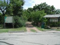
The trailhead has ample parking and a fantastic map of the trails.
The trail starts on the topo map at the waypoint "Trailhead". There is ample parking here and a very good map showing the trails and points of interest along them. The trail heads northeast and follows the backbone of a ridge that becomes more pronounced. At the waypoint "Overlook" there is a nice sitting area with some unexpected views of downtown Austin. This portion of the park resides on a ridge that overlooks Onion Creek and as it turns out, the center of the city.

Numerous dry stream bed crossings dot the trail, but they are easily forded because of the bridges like this one.
Soon after the overlook the trail forks. I ended up going in a clockwise direction and so turned right. The trail descends into and ascends out of the canyon between two ridges then heads north. The trail surface here is mostly packed dirt with some rock. The trail surface was very well maintained and easy to navigate, even in the steeper sections.

The trail descends almost to the level of Onion Creek, though it's never visible. Two ponds dot the path, each with a fishing pier or platform. The second pier is covered and of recent construction. Then it's time to get back up to the ridge top and this involves some of the steeper sections of the hike. A set of log enforced stairs help control erosion of the slopes.

Rabbits, such as this one, were just about the only mammals encountered on the trail. And there were lots of them.
Once on top of the ridge, I came to a side trail that was reported to have led to a primitive camping area. That side trail is represented by the blue track on the topo map leading to the waypoint "Camping Area". My comments about the fantastic nature of the trail maintenance does not apply to this side trail. It was severely overgrown and seemed to peter out completely without an obvious end to the trail. I spent a bit of time deburring myself when I got back to the main trail.
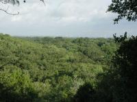
A view along the trail, facing towards downtown Austin in the distance.  Visibility was not ideal on this particular day.
A view along the trail, facing towards downtown Austin in the distance. Visibility was not ideal on this particular day.
Back on the main trail, the path leads south and at the waypoint "View" there is yet another glimpse of downtown. This may be the better of the two views highlighted in the hike, but it's farther away from the trailhead and so does not have as nice a viewing platform.

The trail descends a bit, but then follows the contour of the slope for much of the way back to the fork near the view overlook. From there it's a quick walk back to the trailhead.
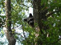
A daytime sighting of a racoon along the trail was an unexpected treat.
Encountering a confused raccoon along the trail in broad daylight was a surprise. He ended up deciding that the tree he was in was not high enough for his taste and he bounded to the ground and into the brush away from the trail as quickly as possible. What they lacked in antics, the rabbits made up for in numbers. I think I must have spotted close to 10-12 rabbits on this hike, more than I can recall seeing on any other.

Several small lakes lie within the park and the nature trail hits each. This one includes a covered fishing pier.
The main trail loop (minus the camping side trail) is a bit over 2 miles. But there's a bit more to explore. Just a short distance from the trailhead another side trail juts to the west that the park refers to as the Wildlife Trail. This one leads to the waypoint "Blind" on the topo map. The Wildlife Trail is not as well maintained as the main trail, but it is nevertheless in better shape than the camping area spur. It descends down the ridge, again almost to Onion Creek level, to a small pond. A blind sits on the edge of the water giving wildlife observers an opportunity to see and not disturb some of the birds that frequent the area. On this particular day there was not much to see.
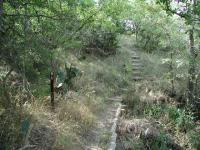
The side trails off of the main loop are more overgrown, such as the Wildlife Trail shown here.
One final "trail" is the service road that runs from the trailhead and arcs its way to the two ponds found along the main loop. This is a wide, rocky jeep trail that is not without its own merits, though the lack of shade on a sunny day made the going a bit rough as the temperatures rose.

In all I was able to squeeze out about 4.75 miles along the trails. The official tally for the park is five miles, two of which is a concrete loop not documented in this writeup and three for the nature trails. In three hours of hiking I only saw two people on the trail, and they were park workers on a cart near the trailhead. This trail is one of the best, if not the best, hike in eastern Travis County. It's got a couple of decent views, well maintained trails, descent terrain and solitude. I know that I'll be back.

Photos
austin
downtown austin from the trail (Photo by jimmy peace)
pond
another of the ponds (Photo by jimmy peace)
pond
one of the ponds (Photo by jimmy peace)
one of the ponds
A button bush by one of the ponds (Photo by plectrudis)
Mesquite scrub
Characteristic of part of the park (Photo by plectrudis)
"Silverpuff" fluffballs along the trail
A pleasant little swath of silverpuffs, a member of the daisy family (similar to, but not the same as dandelions). (Photo by plectrudis)
Pond
One of the ponds in the park. (Photo by Blaze)
View Of The Trail
Parts of the trail involve some mild elevation change. (Photo by Blaze)
Trailhead
This is where the trail starts/ends. (Photo by Blaze)
Hiking Trail Map
There is a display trail map at the trailhead. (Photo by Blaze)
Entrance Sign
This is the sign to the park. (Photo by Blaze)
peter cottontail
a rabbit (Photo by jimmy peace)

Only showing last 12 photos. View All Photos

Log Entries
very dry
By jimmy peace on 9/8/2019
Rating: 3stars Difficulty: 2point5stars Solitude: 4point5stars
Distance: 1.70 Miles Duration: N/A

we need rain,  trails had huge cracks in them, could swallow you up

Overlook and ponds--improved trail needs more trees!
By plectrudis on 10/7/2017
Rating: 2point5stars Difficulty: 3stars Solitude: 2point5stars
Distance: 5.40 Miles Duration: N/A

We hiked the primitive trail loop and then, to pad out our steps, took the unprimitive sidewalk around the playing fields to a jeep track to the shoulder of 71, then back to the trailhead.

The good: the primitive trail is nice and shady and includes a scenic overlook and couple of ponds.  There are flush toilets and picnic tables near the trailhead.

The meh: It's pretty-ish, but it's no Wild Basin or Turkey Creek.  Lots of mesquite.  The primitive trail (the only part that feels like "hiking") is a little short, and much of the paved/graveled non-primitive path is hideously treeless and exposed.  And we accidentally wandered onto private property and had to take the 71 shoulder to get back to the park, which was no kind of fun at all.

The uncategorizable: the battered and dessicated corpse of a mid-size mammal lay in the middle of our path.  We couldn't tell what it was--young coyote? Juvenile hog?  It was certainly interesting, but, lordy, it did not smell good.  

some parts of trail becoming overgrown
By jimmy peace on 10/16/2016
Rating: 2point5stars Difficulty: 3stars Solitude: 4stars
Distance: 3.00 Miles Duration: N/A
By Jamie on 2/9/2016
Rating: 3point5stars Difficulty: 1point5stars Solitude: 2stars
Distance: 5.00 Miles Duration: N/A
By chadjstevenson on 1/22/2016
Rating: 3stars Difficulty: 3stars Solitude: 3point5stars
Distance: 5.00 Miles Duration: N/A
Hiking Trails And More
By Blaze on 4/22/2014
Rating: 1point5stars Difficulty: 1star Solitude: 1point5stars
Distance: 8.40 Miles Duration: 3 hours, 2 minutes

Southeast Metropolitan Park is a large municipal park that has numerous amenities, including athletic fields, play areas for kids, picnic spots, a paved walking/jogging path, and a network of dirt trails for hiking.

I went to Southeast Metropolitan Park primarily for the hiking trails, but also walked the rest of the park for additional mileage.

Rerating
By texaskdog on 2/22/2014
Rating: 3stars Difficulty: 2stars Solitude: 3stars
Distance: 2.75 Miles Duration: 1 hour, 4 minutes

Glad I reread this before we went.  They oiled the driveway and it was closed, but knew there was a concrete trail.  we went to the right and it counted down instead of up, and actually got lost once.  It is nice but once in 4 years is enough for us.  If you're out this way McKinney Roughs is nicer, longer, and worth the extra drive.  Some idiots playing soccer had their radio so loud we could here it all the way up a good chunk of the path.

By crocodile235 on 8/17/2013
Rating: 5stars Difficulty: 3point5stars Solitude: 5stars
Distance: 5.50 Miles Duration: N/A
By jimmy peace on 6/9/2013
Rating: 4stars Difficulty: 3stars Solitude: 5stars
Distance: 3.50 Miles Duration: N/A
awesome county park winds around three stock ponds.. saw rabbits, birds, etc
Perfect Hike... except for the cobwebs
By mstacer on 7/4/2012
Rating: 4point5stars Difficulty: 3point5stars Solitude: 4point5stars
Distance: 3.00 Miles Duration: 1 hour, 5 minutes

I was very impressed by this trail except for one thing... the cobwebs.  Holy crap.  I have to say, I am not a squeamish gal.  I don't mind bugs, spiders, snakes, mud, etc.  And I LOVE hiking and backpacking with my dogs so I'm willing to put up with a lot.  But I am not exaggerating when I say I was hit in the face with cobwebs every 15 seconds or so.  And not just a string of cobweb, a full-on spider web.  It was almost comical, but I got to the point where I just wanted it to be over... and that's sad to say about any hike.  I found a 3-foot branch shaped like a leaf rake and swung it in front of me the whole time to clear the way.  It actually had me thinking twice about coming back.

And that's a shame because this trail has everything else I want in a hike.  Only 30 minutes away, a full loop, just over an hour to hike, no one else on the trail, tree cover the whole time, and ponds for the pups to swim.  The trail is narrow, lots of up and down and bridges, all the hills and trees make you feel very secluded.  It's beautiful.  I will give this place another shot, but not until the fall when it's cool enough to come later in the day when someone else has cleared the way for me. :)

Only showing last 10 log entries. View All Log Entries

Recommended Item
Recommended Item 60 Hikes Within 60 Miles: San Antonio and Austin: Including the Hill Country
Charlie Llewellin, Johnny Molloy
List Price: $18.95 Your price: $15.91 Buy Now
It's Time to Take a Hike in San Antonio!

The San Antonio and Austin areas are steeped in history -- San Antonio's Alamo stands as a symbol of Texas' fierce independence, while Austin is recognized as the cradle of Texas statehood. This area is also known for some of the most impressive hiking in the Lone Star State. 60 Hikes Within 60 Miles: San Antonio and Austin, by veteran authors Charlie Llewellin and Johnny Molloy, guides readers to the best trails found in the Texas Hill Country, all within easy reach of these two cities. The guide takes you to secluded, low traffic areas as well as those that are more popular and heavily used. The former LBJ Ranch, the Guadalupe River, the Highland Lakes Chain, and the Lost Pines area are just some of the spectacular places covered.

With this new edition in the best-selling 60 Hikes Within 60 Miles series, all these visually stunning and ruggedly charming routes are at the traveler's fingertips. This handy guide helps San Antonio and Austin natives get back into nature, with many options right in town. Extensive at-a-glance information makes it easy to choose the perfect hike based on length, difficulty, scenery, or on a specific factor such as hikes good for families, runners, or birding. Each trail profile includes maps, directions, driving times, nearby attractions, and other pertinent details.