Canyon of the Eagles - Lakeside

Trail
12.00 Miles
650 Feet
$5.00
3stars (3.38)8
2stars (2.06)
3stars (3.38)
Yes
Yes
Yes
No
Burnet
Burnet
More Info

The Bird and Butterfly Trail west of the Trailhead is the easiest and provides the most shade.
Getting there: From Burnet, head west on Hwy 29. Turn right and head towards the northwest on FM 2341. Continue on 2341 for several miles until it dead-ends at the park entrance. After entering the park turn left behind the entrance station building and park at the trailhead on the right. Be sure to get your day pass at the main Lodge first.

The Hike: The trails at Canyon of the Eagles are a complex of loops that allow for creating a hike of almost any length requiring any level of effort you desire. Upon entering the park be sure to follow the signs to the west towards the main lodge where you can pay the park's entrance fee and pick up a trail map.

The trail maps at Canyon of the Eagles are just about the best trail maps that you'll find anywhere. Printed on sturdy stock, they include contour lines more precise than you'll find on most USGS maps. All trail intersections are numbered and the actual trail markers in the field bear the same numbers making it easy to figure out exactly where you are and how to get where you want to go.

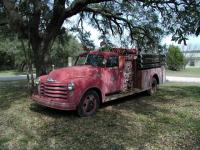
I'm not sure how an old, rural fire truck from Morrill, Nebraska ended up near the trailhead.
I actually started my hike at the alternate trailhead just north of the "Trailhead" waypoint where I parked my car. This is just a short hop away and the trail here starts near the bulletin board for the Eagle Eye Observatory. The parks calls this the Faris Lookout Trail and it heads north towards a hilltop just on the northern boundary of the park.

The trail leading to Faris Lookout was lush with green grasses, early enough in the year to not be a nuisance.
On a mild winter day it almost felt like spring was coming on. Moisture was in the air, clouds were moving in later in the day and the grass along the trail was a vibrant green. It was like walking on carpet in some spots. Later in the spring and summer this same grass may be more of an annoyance when it starts to get to knee-height.

When the trail nears the waypoint "View" keep an eye out on the left for the continuation of the trail. Once you get to the actual view you'll need to double back a short distance to it. Don't try to follow the fence line westward here. That's not the official trail.

Lake Buchanan as seen from Faris Lookout.
Unlike the Juniper Ridge trails, the elevation gains and descents here are mild with much of the elevation gain spread out over a larger area. The trails leading up to and down from the "View" waypoint are just about the steepest on this side of the park. One could easily follow the trails that line the lake and avoid the elevation gain altogether, but you'll just be missing out on the most remote portions of the trails that provide the best views. In general, the eastern half of the trail system is hilly and the western half flat.

There's not much shade along most of the trail.  A scattering of oaks, a few Junipers and lots of shrub.
There's not much shade along most of the trail. A scattering of oaks, a few Junipers and lots of shrub.
Heading west from the view I looped around every trail that I could find, first filling up the hillier eastern trails, shuffling between waypoints "13" through "18". Arguably there is a better view of the lake on the Vireo Hill Trail between waypoints "15" and "16". Though not as high up and with somewhat less lake showing, the view is not hampered a high fence in the field of view.

The trail cuts through the shrubs with Lake Buchanan in the distance.
Compared to much of the hillcountry, there was a surprising lack of Juniper in many places along the Lakeside trails. Historically Juniper was not as prevalent as today and in order to provide the variety of habitat found in the past the Juniper may have been cut back by the park staff. The thickets of brush that would have perished under a canopy of Juniper seemed to attract a large number of birds including Cardinals, Robins, Mockingbirds and Sparrows. Although Golden Cheeked Warblers need Juniper for their nest building materials, the Black Capped Vireos actually prefer Shin Oak and other shrubs and nests about 2-4 feet off the ground. So the cover here may be more to their liking.

Looking down on the trails near Tanner Point.  The structure on the left is a deer blind.
Looking down on the trails near Tanner Point. The structure on the left is a deer blind.
I finished off my 9 miles of hiking by completing the trails along the lake shore. There are more people in this area, particularly near the waypoint "Tanner Point" given its close proximity to the park's camping areas. Although at the height of Bald Eagle season, I failed to spot any along the lake, much to my disappointment.

Two sections of the trail are closed at certain times of the year for endangered and threatened species protected. The eastern half of the Lakeside trail system is closed from March 1 through August 31 for the Golden-Cheeked Warbler and the Black-Capped Vireo. I think this half of the trail is the best half, so you may want to plan your visit for fall or winter. Another much smaller section of the trail along the lake is closed from November 1 - March 15 for the Bald Eagles.

Log Entries
lots of butterflies
By jimmy peace on 4/10/2016
Rating: 3stars Difficulty: 1star Solitude: 2point5stars
Distance: 2.50 Miles Duration: N/A
Canyon Of The Grasshoppers
By Blaze on 6/21/2013
Rating: 1star Difficulty: 1point5stars Solitude: 3point5stars
Distance: 8.00 Miles Duration: 2 hours, 58 minutes

I visited this LCRA park on my way to Colorado Bend State Park.  I had hoped to get 14 miles of hiking in, but I failed to realize that several of the trails are closed from March 1 through August 31 to provide better nesting conditions for the Golden-Cheeked Warbler and the Black-Capped Vireo.

NOTE:  Previous logs by other members have mentioned this, but I overlooked this detail and, as a result, found myself backtracking in search for alternate routes.

Frankly, I wasn't that impressed with this park.  There wasn't a lot to see.  Just trails to walk.  Instead of seeing eagles, I saw thousands of grasshoppers.  The place was literally infested with these insects.  I did include a detour out to the Eagle Eye Observatory to see what was there.  It was closed, of course, in the daytime, but they do allow public access on some evenings (check the Lodge for the schedule).

On my walk back from the observatory, I encountered a 6' long rattlesnake on the road.  This rattled me a bit, no pun intended, but I thought I should mention this so others are aware of this when they decide to hike the trails in the area.

Hot but nice.
By BANDA on 9/3/2012
Rating: 3point5stars Difficulty: 1point5stars Solitude: 5stars
Distance: 3.20 Miles Duration: N/A

We stayed in our RV at Canyon of the Eagles over the Labor Day holiday. Thank goodness for the A/C as it was over 100 degrees each day! So hiking was limited to the early morning hours. The park was full, but during our morning hikes we saw no other people on the trails! Lots of solitude! And lots of doves. Campground is nice and quiet as well.

We saw an eagle!
By perk1963 on 6/9/2007
Rating: 4stars Difficulty: 3stars Solitude: 5stars
Distance: 7.00 Miles Duration: 2 hours, 30 minutes

Lots of different things to see on this hike.  My dog was humbled by his experience seeing an eagle fly from his nest.  Loved the butterflies in the sea of yellow wildflowers.  We saw not one soul during the entire hike.

Lots of birds
By nobody on 2/20/2005
Rating: 5stars Difficulty: 2stars Solitude: 3point5stars
Distance: 5.00 Miles Duration: N/A
Very very good map, well marked trails, not many people. Not very long. Most of the trails close on March 1, so 1 more weekend before they go bye-bye.
Birds Galore
By Austin Explorer on 2/5/2005
Rating: 3point5stars Difficulty: 3stars Solitude: 3point5stars
Distance: 9.00 Miles Duration: N/A
Came back with the intention of finally hiking every last trail I missed last time I was here. In a total of 9 miles of hiking I only saw four other people on the trail. Although it was the Bald Eagles are in the area I was not fortunate enough to see one, though I saw a very large number of other birds flying through the brush. Note that the western-most trail is closed due to the Bald Eagles in the area through March.
A very hot day
By Austin Explorer on 8/1/2004
Rating: 3stars Difficulty: 3stars Solitude: 3point5stars
Distance: 4.06 Miles Duration: N/A
The heat was fairly brutal on this hike, which made a bit over 4 miles seem a lot longer. The heat must have scared away others, as we saw few people on the trail. Since the east side of park was closed for Warbler breeding season we hiked the trails on the western edge near the shore of Lake Buchanan. Most of the trails are easy with just a little bit of elevation gain. Stood for several minutes within 2 feet of an armadillo as he foraged for food. There's so much more to hike out here that we'll be back.
Canyon of the Eagles
By Eveline on 2/23/2002
Rating: 4stars Difficulty: 1point5stars Solitude: halfstar
Distance: N/A Duration: N/A
Transferred to Canyon of the Eagles. Won't Delete.
Recommended Item
Recommended Item Lone Star Travel Guide to the Texas Hill Country
Richard Zelade
List Price: $18.95 Your price: $17.61 Buy Now
This book brings the remarkable Hill Country of Texas home to the back roads traveler. Whether it’s wildflowers you’re drawn to, or dude ranches, natural areas, historic sites, or quaint Texas towns redolent of history, this is your passport to an experience like no other. Backroads of the Texas Hill Country introduces travelers and armchair tourists alike to the emerging wine country of the Lone Star State, the meticulously preserved culture of East European immigrants, the “cowboy capital of the world” (Bandera), and the childhood home of LBJ at Johnson City. Follow this irresistible guide into the Hill Country, and find yourself deep in the heart of Texas.