-small.jpg)
The Palmetto Trail gets its name from the abundant Dwarf Palmettos that line the trail.
From Austin head south on Highway 183. Proceed through Luling and turn right onto Park Road 11 south of town. The park ranger station is two miles down the road on the edge of the town of Ottine. To get to the trailhead for the Hiking Trail continue down Park Road 11 and turn left after crossing the third bridge. Park near the Rectory building and head back up Park Road 11 looking for the trailhead on the left. Note that you'll pass the trail exit before the trailhead.
The Hikes: This short hike is the signature hike of the park. It includes the largest concentration of Palmettos that you're likely to see in this part of the country. The trail begins at the trailhead marked by the waypoint "Trailhead" on the topo map.
The Palmetto Trail is one of two trails in the park that features an interpretive trail guide that describes many of the plants that can be found here. The guide is available in a box at the trail end, which you will pass on your way from the parking area at the Refectory.
This water is part of the man-made system that keeps the area moist enough to maintain its Palmetto population.
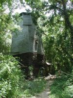
A short distance after the trailhead the path comes upon a water tower partially shrouded by the forest. What's a water tower doing here? Human activity in the area has drastically changed the environment. Oil and water pumping in the area has altered the flow of underground water that the Palmetto groves relied on for moisture in the past.
In order to save the Palmettos that remained here, the Civilian Conservation Corps built an artesian well to pump water from deep underground and bring it to the surface. The water tower stores some of the water before it is released at the surface.
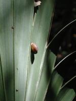
Palmetto leaves are a favorite spot for several land snail species. Some individual plants hosted scores of snails.
The trail is very flat and easy to navigate. Very often the trail is framed by thick stands of Dwarf Palmettos. Although Palmettos can grow to as high as 18 feet tall, that does not happen much within the park boundaries. Instead, those within the park have the tops of their foliage stand between three and four feet tall. During our visit in August the Palmettos had already passed the flowering stage and were bearing small spheres of fruit on stalky stems.
The Palmetto leaves are a favorite spot for several land snail species. One of them,
Stenotrema leai cheatumi, was first discovered to science in this very area. In addition to the Palmettos, the snails seem to prefer the bark of the hackberries over those of other trees.
-small.jpg)
The trail is quite easy to hike. This small bridge even makes getting over the small gully easy.
The Dwarf Palmetto is more common along the Gulf Coast from Louisiana to Florida. The population of Palmettos here are somewhat out of their typical range. In this regard they share some characteristics with the Lost Pines or Lost Maples. The plant's exotic shape, combined with the fact that they seem out of place in South Texas leads the feeling that one is walking through an ancient landscape.
The trail parallels the road towards the northeast before returning to the road at the waypoint,
"End". We recorded the hike at .15 miles and we covered the distance in about 30 minutes, with some of that time spent reading the interpretive trail guide descriptions. Although we recorded a hike distance less than that of the publicized one third of a mile, the Palmettos and the interpretive guide make this the one hike that you should take if you only have time for one trail in Palmetto State Park.