Getting there: From MoPac heading north, take the Northland Drive exit and head
east. Turn left onto Shoal Creek Boulevard and continue north for about half a mile. Northwest
District Park will appear on the right first as an entrance for a small baseball stadium, which
I used for my hike. However, the more appropriate parking area is at the northeast side of the
park off of Albata Avenue. To get there turn right at Greenlawn Parkway and then work your way
back to the south to Albata.
-small.jpg)
Parts of the trail run along the top of the embankment meant to hold back flood waters of Shoal Creek, which runs along the park's western edge.
The city of Austin does not claim that there is a hiking trail
at Northwest District Park. In a way they're right. However, there is a path around the
perimeter of the park that can be enjoyed by nearby residents.
My hike started at the baseball stadium situated at the southernmost point of the park.
Note that I do NOT recommend that you start your hike there. The normal parking for the park
resides further north and I'll pass by the spot later on during my hike. While the parking area
for the baseball diamond was open on this day that will not always be the case.
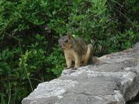
While the park does not provide a wilderness experience the park does contain lots of wildlife, of a sort. Squirrels and birds are in abundance within the park boundaries.
The trail starts off to the north climbing on an Earthen mound that parallels Shoal Creek
to the left. The creek has been prone to flooding in the past and some parts of the park
were put together from the property of former homes that have flooded through the years.
The main portion of the park can be seen to the right. The facilities of the park include
a swimming pool, basketball courts, tennis courts, picnic areas and playscapes. The walking path
seems to be something of an afterthought, particularly on this side of the park.
-small.jpg)
The highlight of the hike is the picturesque pond at the park's center, which includes a small island.
The trail turns to the right when it runs to the northern park boundary. It crosses the
driveway and dumps into the parking area in front of the pool. This is the spot where I
recommend that you park when you visit. There are a lot more cars and the parking area will be
open whenever the park is open.
To complete the loop around the park continue to loop around the pool area. Once on the
far side a paved path will emerge as it heads back towards the southern end of the park.
On the right there are a large number of picnic tables and playscapes. During my visit
there seemed to be several children's birthdays going on at the same time.
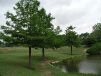
Planted along the pond's shore are several Cypress trees.
The most interesting portion of the park is the pond that resides along the trail right before
it rejoins the path leading back to the ballpark. There's a picturesque island in the middle
of the pond and the surrounding area seems overloaded with squirrels and birds. Trees
along the banks of the pond appear to be Cypress, planted in a neat row along the pond shoreline.
The trail climbs up the berm back onto the path used to join the southern end of the park
with the north end. From this point on the hike I just retraced my steps back to the
baseball parking area. I spent about 30 minutes in Northwest District Park and I might
have been disappointed with the trip considering the number of people present. However,
the pond, island and squirrels provided an enjoyable respite along the way.