Goat Cave Preserve

Trail
0.60 Mile
34 Feet
N/A
2point5stars (2.94)10
1star (1.10)
3stars (3.00)
N/A
No
No
No
Austin
Travis
More Info

Getting there: Head south on MoPac well past Town Lake. Turn left on William Cannon and then right on Brodie Lane. Head south on Brodie and then turn right onto Deer Lane. The preserve is a few blocks down Deer Lane on the right. Look for parking along the wide shoulder of the road before it narrows just past the preserve.

The Hike: The trail starts at the waypoint marked "Trailhead" just off of Deer Lane. Here stands an informative display showing the features that exist in the preserve and why it is important that they be protected.

The start of the trail features an informative educational display.
The first section of the trail is compacted dirt that makes for easy going. Towards that back of the preserve the trail turns more rocky but remains relatively easy to traverse. Almost immediately after starting the hike the trail turns to the left and the first karst or sinkhole comes into view. Wade Sink is so close to the trailhead that the map for this hike does not bother showing a separate waypoint.

The trail between the three karsts is flat and well shaded my numerous oak trees.
The Goat Cave Preserve was set aside to buffer some of the ecologically sensitive karsts in the area from the housing that is surrounding it more and more. Karsts are caves that feed directly into the Edwards Aquifer below ground. Any trash or runoff that washes into the karst stands a good chance of eroding the quality of a water source used by many people in Central Texas.

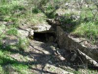
This cave has been known to shelter numerous animals inhabiting the preserve.
The trail heads towards the north through numerous Oak trees that populate the area. On this day we were treated to a large number of Mourning Doves who kept a close eye on us but even more so on the stray cat that we saw dart into the brush. A second cave along the trail is marked by the waypoint "Cave". This cave is known to serve as habitat for some of the local wildlife, including a possible fox. While no barrier exists, access to this cave is strictly prohibited to provide refuge for the animals that inhabit the area.

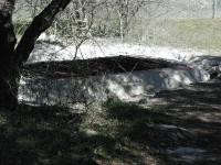
Through gaps in the protective fence this is the best view one can get of Goat Cave, the largest karst in the preserve.
Farther up the trail is Goat Cave, the main karst in the area from which the preserve draws its name. This cave serves as the home of a colony of bats and the city has started to take steps to restore the karst to a healthy environment for them. Years ago, in an effort to keep people from falling into the 28 foot drop at the entrance a large metal grate was placed over the opening. The problem with the grate is that the spaces between the bars are too small to allow easy bat movement to and from the cave.

The city's solution is to put up a fence around the perimeter of the karst. Presumably the grate will be removed at a later date. It's a good solution, but the fence surrounding the karst uses a chain link material that's so thick that it's hard to get a good look at the cave entrance.

The trail in the back half of the preserve is more rocky, but still easy to navigate.
The trail continues north past Goat Cave and the going becomes a bit rockier. Much of the remainder of the path follows along the preserve's western boundary which is marked by a barbed wire fence. The end of the trail occurs at the waypoint "Turnaround". Here the trail empties into a residential rain water retainment basin. The hike continues along the exact same path back to the trailhead.

Goat Cave Preserve provides a short, easy hike ideal for beginners, those with children and those wanting to find out more about the Edwards Aquifer and geology of Austin and the surrounding Hillcountry. The trail can be hiked within 30 minutes including some time to wonder at the karsts the preserve protects.

The hike's solitude rating is a tough one to gauge. While we saw no one else on the trail it's hard to say one achieves any level of solitude. Houses back up within 100 feet of the trail at times. The sound of auto traffic and even air conditioner compressor units reminds the visitor that while they have stepped out of the human world for a moment, they have not travelled very far from it.

Photos
hidden cave
two of the three caves (Photo by jimmy peace)
wade cave
one of the two caves (Photo by jimmy peace)
Log Entries
part of my bucket list
By jimmy peace on 3/24/2019
Rating: 2stars Difficulty: halfstar Solitude: 4stars
Distance: 0.50 Mile Duration: N/A

tiny, but it was on my bucket list to do 

By AustinSlacker on 7/3/2018
Rating: 3point5stars Difficulty: 1star Solitude: 2stars
Distance: 0.60 Mile Duration: N/A
Goat Cave
By Ollie on 1/18/2010
Rating: 1star Difficulty: 1star Solitude: 5stars
Distance: 1.00 Mile Duration: 15 minutes

Saw the Goat Cave, the fence, and a large dog.... sadly no Goats.

On the way home from work.....
By perk1963 on 4/27/2007
Rating: 4stars Difficulty: 1star Solitude: 5stars
Distance: 1.20 Miles Duration: 20 minutes
I'd read about this and stopped for a short walk right before sundown. Not a soul out there. Maybe not worth a long drive, but if you're in the neighborhood, it sure beats the same old loop around the block. Be careful crossing the road, lots of maniacs at that bend in the road.
Out Geocaching
By rilekyle on 2/24/2007
Rating: 2point5stars Difficulty: 1star Solitude: 1point5stars
Distance: 0.60 Mile Duration: N/A
By lancescape on 1/7/2007
Rating: 3stars Difficulty: 1star Solitude: 2point5stars
Distance: 1.00 Mile Duration: N/A
Virtual Geocache Hike
By nowheregirl on 10/1/2005
Rating: 4point5stars Difficulty: 1star Solitude: 5stars
Distance: 0.60 Mile Duration: N/A
This was a hike I went on as part of a day of geocaching. Enjoyed it very much.
A bit muddy
By Austin Explorer on 7/31/2005
Rating: 3stars Difficulty: 2point5stars Solitude: 1point5stars
Distance: 0.60 Mile Duration: N/A
I'd hiked and documented this trail before, but forgot to actually log my hike! Went back to check on a virtual cache sign and decided to make it official this time around.
Quick and easy
By DivasDude on 3/22/2004
Rating: N/A Difficulty: 1star Solitude: 2stars
Distance: 0.60 Mile Duration: N/A
Went to check out the cave and hike a nice afternoon walk.
Not a lot here
By figment on 4/17/2003
Rating: N/A Difficulty: 1star Solitude: 1point5stars
Distance: 0.50 Mile Duration: N/A
There isn't a lot to see here, Goat Cave is fenced in, and impossible to really see, and the other two sink holes aren't much too look at either. It's a nice hike if you are in the area, or live in those homes.
Recommended Item
Recommended Item 60 Hikes Within 60 Miles: San Antonio and Austin: Including the Hill Country
Charlie Llewellin, Johnny Molloy
List Price: $18.95 Your price: $15.91 Buy Now
It's Time to Take a Hike in San Antonio!

The San Antonio and Austin areas are steeped in history -- San Antonio's Alamo stands as a symbol of Texas' fierce independence, while Austin is recognized as the cradle of Texas statehood. This area is also known for some of the most impressive hiking in the Lone Star State. 60 Hikes Within 60 Miles: San Antonio and Austin, by veteran authors Charlie Llewellin and Johnny Molloy, guides readers to the best trails found in the Texas Hill Country, all within easy reach of these two cities. The guide takes you to secluded, low traffic areas as well as those that are more popular and heavily used. The former LBJ Ranch, the Guadalupe River, the Highland Lakes Chain, and the Lost Pines area are just some of the spectacular places covered.

With this new edition in the best-selling 60 Hikes Within 60 Miles series, all these visually stunning and ruggedly charming routes are at the traveler's fingertips. This handy guide helps San Antonio and Austin natives get back into nature, with many options right in town. Extensive at-a-glance information makes it easy to choose the perfect hike based on length, difficulty, scenery, or on a specific factor such as hikes good for families, runners, or birding. Each trail profile includes maps, directions, driving times, nearby attractions, and other pertinent details.