Getting there: Our hike started at the back of Pflugerville High
School. To get there head north on I-35 and take the FM 1825 exit. Head east on 1825,
which will turn north very soon after exiting from I-35 and then twist and turn a couple of
times as it becomes Pecan Street. After crossing Heatherwilde Blvd. prepare to turn
into Pflugerville High School on the right. Aim for the football stadium parking area and
work you way to the back of the school property west of the stadium.
The Hike: Pflugerville's answer to the Town Lake hike and bike trail is
an enjoyable series of trails that wander through the city, mostly along the banks of
creeks in the area. It provides a wonderful alternative to the more crowded area in
downtown Austin.
-small.jpg)
Pflugerville's trail system is completely paved, making it ideal for joggers or beginning hikers.
The City of Pflugerville promotes the trail on its web site via a
trail map
available online. Unfortunately, some of the paths marked on the map appear to be future
plans instead of actual trails and one street crossing is potentially dangerous. However,
the trails that we discovered were enjoyable and convenient and can be enjoyed safely if
the Pecan Street crossing is avoided with small children.
The trail system has numerous entrances throughout its length. We started our hike in the
back of Pflugerville High School at the waypoint marked "Trailhead". Here a small bridge
crosses over a canal and the trail heads in a straight line to the south east. Throughout
the trail you'll have a well-built concrete surface, making it perfect for those who do
not enjoy rouger terrain.
The first creek crossing marks the end of what Pflugerville calls the Settler's Valley Trail.
At 1.4 miles into the hike at the waypoint "Creek Crossing" the trail empties into a
residential cul-de-sac. If you fail to pay attention you might not notice the trail
continuation on the other side of the street. A narrow path cuts between the backyards of two
of the houses. Once clear of the homes the trail heads north towards downtown Pflugerville.
Pflugerville calls this section the Pfairways Trail.
Judging from the Pflugerville map it would appear that the Pfairways Trail follows along
the east side of Railroad Avenue. But it doesn't. Instead it actually sits west of
the new Dessau Road. The trail soon descends into a creek bed, though like the rest of the trail
remains paved. This section obviously should be avoided during rainy times.
-small.jpg)
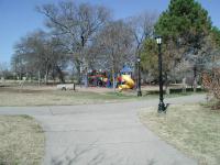
Gilleland Creek as it passes through Pfluger Park.
The trail seems to end near the fire station in the middle of Pflugerville. A waypoint
marked "T-Left" may be hard to read under the "Athletic Field" notation on the topo
map. On our hike we incorrectly guessed that construction to the right of the
intersection of Railroad and Pecan would prevent us from getting to the trail on the
other side of the road. So, we crossed through the parking area behind the fire
station and used the light at Pecan and Railroad to get across the busy road safely.
Since we knew that the trail passed under Railroad Avenue further north we just hiked
along the road until the trail passed beneath us. A Simple hop over the railing and
down the slope and we were back on the real trail. We passed under the bridge that
crosses Gilleland Creek and headed west into Pfluger Park.
Pfluger Park has playscapes and picnic areas, so it will be the most crowded portion of the hike.
The trails in Pfluger Park continue to parallel Gilleland Creek. At the far end of the park
the trail crosses the stream and turns back toward east, eventually crossing the creek
again near the large playscape and turning back towards Railroad Avenue. We could find no
trace of a trail leading from Pfluger Park to a "Heritage Trail" to the north as indicated
on the Pflugerville map.
Retracing our steps back to Railroad Avenue we stayed with the trail as it passed under
the bridge once more and continues following Gilliland Creek downstream to the southeast.
The trail passes under Pecan Street at the waypoint marked "Mural - Construction". We
had to proceed with caution here as there was a lot of construction going on in the area.
Part of the Pecan Street bridge was demolished as construction crews prepared to widen
the roadway. Be sure to see the fish mural beneath the bridge before its gone.
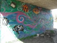
This amusing mural resides along the trail as it passes under the Pecan Street bridge. Hopefully some of it will be saved from the current construction.
The trail passes under Dessau Road right after passing under Pecan. Note that this Dessau
Road is not the Dessau Road shown on the Pflugerville trail map but rather the extension
of FM 685. Old Dessau Road is a short distance down the trail on the other side of Bohl's
Park.
The trail enters Bohl's Park just east of "New" Dessau Road. One of the interesting
features here is the old Railroad bridge that now serves as a pedestrian bridge over
the creek. Here again, we run into a dead end, trailwise. The Pflugerville trail
map shows a trail continuing on the east side of Old Hutto Road (the extension of
Old Dessau Road north of Pecan). But we could not see it. There appeared to be
a sidewalk on the west side of the road that ended in a block or two. On the east
side there was a sound barrier wall for the Bohl's Place subdivision. So, we turned
back with the elusive Pflugerville Loop still out of our grasp.
On the route back to the trailhead we found an alternate route across Pecan Street that
avoids the hike along Railroad Avenue. United Methodist Church has a large parking lot
that adjoins the trail and feeds into Pecan. Cross the street there with extra caution.
The traffic is moving quickly and there is no stop light or crossing sign to assist
pedestrians. Worse, with the construction going on up and down the street visibility is
less than it would otherwise be.
-small.jpg)
A pedestrian bridge next to Old Dessau Road appears to be using an old railroad bridge.
On the opposite side of the street a road is being rebuilt. Walk down it and take the next
right. A short distance ahead you should be able to see the Pfairways Trail where it ended
downtown. Now the trail merely follows the same path back to the trailhead.
While we were disappointed that the expected Pflugerville Loop did not materialize and we
were somewhat put off by the temporary construction in the area, we could not help but be
impressed by the trail system Pflugerville has built. For those who wish to avoid the
construction hassles this trail offers two very easy and convenient segments that provide
up to 3 miles of out and back pfun (sorry!) through Pflugerville.