Getting there: From Panther Junction, head west on Hwy 118. Turn
south onto the Ross Maxwell Scenic Road and proceed for about 13 miles, looking for a
sign indicating the Chimneys Trail on the right. Park on the extended shoulder.
The Hike: Mention a desert hike to most people and they conjure up images
of Gary Cooper in the movie Beau Geste among the sand dunes. However, the portion of the
Earth's surface referred to as desert do not all consist of oceans of sand. The Chimneys
hike in Big Bend National Park provides a different view of the desert.
-small.jpg)
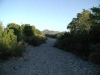
The trail consists of a well worn path through the desert. The Chimneys are low in the distance to the right of Kit Mountain.
The trailhead for the Chimneys hike starts along the side of the Ross Maxwell Scenic Drive.
Far off into the distance one can see the turnaround point for this hike. A row of rock
outcroppings spread out across the desert floor. The Chimneys from this distance are
overshadowed by Kit Mountain to the south, but the Chimneys will make their impression
later.
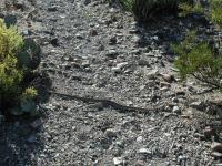
The trail here may be harder to find and keep track of than some of the trails in the
Chisos Mountains, but once you know what to look for there is not much of a problem. The
ground here is rocky with compacted soil. Look for a well worn line that almost
resembles a shallow bowling lane gutter and you've found the trail. Even if you lose
sight of the trail the start and end points are clearly visible, so getting lost should
never be an issue.
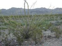
Desert plants, such as this Ocotillo, have adapted to the dry environment in unique ways.
Obviously desert hiking calls for a few precautions that might not be as important on other
hikes. First, the desert can become extremely hot, particularly during the summer.
Consider tackling this trail during the cooler months of the year. We hiked the trail in
October and the weather was perfect. Second, there is no water on the trail and even if you
found some during a wet period you should not drink it. Always bring water with you on this
trail and bring lots of it. Third, pick the time of your hike carefully. By starting off
very early you can avoid hiking in the hottest parts of the day. We started just before
Sun up. Lastly, wear Sun screen. There is no cover and thus no protection for your skin.
The dry creeks that run through the area carry enough moisture to support relatively lush vegetation on a thin line in the desert.
The trail progresses in what appears at times to be a straight line. Directly behind the
trail, looking back towards the trailhead loom the Chisos Mountains, which harbor a
world very different from this one. The vegetation here is sparse, but there is surprising
variety and abundance. Prickly Pear cactus is here as you would expect, but many other
natives predominate. One of the largest is the Ocotillo plant. This interesting plant
consists of limbs that grow leaves along its length with no dividing branches. This all
trunk and leaf design has a purpose. In times of drought the Ocotillo preserves water by
drawing its moisture into its tough trunk and shedding the leaves until a wetter period
arrives.
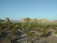
The Chimneys come into view. This line of rock formed under ground eons ago and was exposed when the surrounding rock eroded.
The lack of moisture prevents plants from clustering too densely. Typically plants are
buffered from others by bare soil, which mostly consists of rock and gravel. Looking out
onto the horizon though it becomes apparent that there are ribbons of denser growth. These
lines of plants and trees follow the paths of dry streams in the area. While no water
was present in any of the streams when we visited the extra moisture that they provide was
just enough to allow the more thirsty plant varieties to grab ahold of life in the desert.
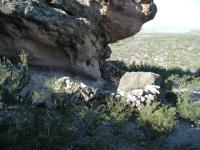
Nearby a rock overhang provided a good place for Indians to build a shelter from the elements. These remains have not been reconstructed.
As you continue to head west along the trail the Chimneys will begin to rise above the
horizon. The Chimneys are a volcanic dike formation that was created within a fissure of
rock beneath what was then the surface of the Earth. As the softer, more erosive rock
around it weathered away the Chimneys were exposed. This distinctive formation served
as a valuable point of reference for Indians who lived in the area for hundreds of years.
Once the trail arrives at the Chimneys smaller trails fan out between and around the
sections of the formation. Evidence of the importance of the Chimneys to the local
Indians can be found in the pictographs that are carved on one of the flat stone
surfaces of the southern-most spire. To ensure that the carvings are preserved for
future generations you should not disturb nor even touch them.
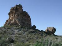
The southernmost Chimney stands apart from the rest.
On the western side of the Chimneys sits a large rock that overhangs the remains of a small
dwelling. The remains of the stone walls rise to waist height. Inside the walls lay a
couple of grinding stones. According to a Park Ranger the native Indians used this area
for seasonal shelter. A nearby spring provided them with the water they needed.
After investigating the Chimneys and the signs of Indian life around it we headed back towards
the trailhead. Optionally, the Chimneys trail continues westward for another five miles to
Luna Jacal. The trip back to the trailhead is all uphill. But the slope of the land is
gentle so there is no strenuous effort required.
Yield to any snakes along the trail and they'll go about their business and leave you alone.
On the trip back to the trailhead we had our second encounter with a Rattle snake during our
Big Bend trip. This time a snake was crossing the trail about 4 feet in front of us before we
noticed him. Our first sign was the movement of the snake as he backed up from the trail to
the base of a plant and eyed up suspiciously. After a few moments of standing still he
sensed we were less of a danger and continued crossing the path. Like our earlier
encounter, at no time did the Rattle snake rattle or make a threatening move. Rattle snake
attacks in Big Bend are very rare. Provided you leave any snake you find alone you
need not worry too much about encountering a snake along the trail.
The solitude of the hike is grand. During our three and a half hours on the trail we saw and
heard only one other group who continued on to Luna Jacal to the west for a 7 mile one way trip.
When visiting Big Bend it's important to experience the variety that the park has to offer. Should
you have only a day to spare in the desert the Chimneys hike would be a very good choice indeed.