Getting there: The easiest starting point is just a stone's throw from
the Chisos Mountain Lodge parking lot. Near the start you'll find a large wooden sign with
arrows pointing in various directions towards the trails that start near that point. Go in the
direction of Laguna Meadow or South Rim.
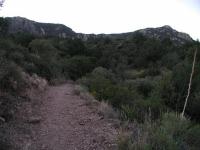
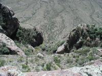
The South Rim trail starts off easy, but you can see in the distance where this will take you.
The South Rim trail straddles the boundary between a backpack trail
and a dayhike trail. At 12.6 miles it tends to fill up the better part of the day and leaves
one quite drained at the end. There are several excellent camping areas along the trail. But
if you insist on tackling it all in one day like we did then you should get as early a start
as possible to give yourself lots of time to enjoy the views and get back to the Lodge
before sundown.
We started off at the waypoint marked "Trailhead". Here you'll find a large wooden sign pointing
out the direction to various trails. At the start the trail the gentle hills are in
contrast to what lies ahead. Enjoy the easy terrain and get loose for the harder work
ahead. The waypoint "4way" marks a major trail juncture. However the metallic signs that
you'll see throughout the trail makes it easy to determine the proper direction. For now,
follow any sign that points toward Laguna Meadow or the South Rim.

This bunny along the trail did not seem too afraid of humans.
Upon approaching the waypoint "Switchbacks" the easy going is over for now. Here you start
in earnest the effort to get to the ridge that overlooks the Chisos Basin floor. Switchbacks
make going up steep slopes easier, though that by no means implies that getting to the top
of this ridge is easy. Expect to huff and puff a bit. Take a few breaks. Drink lots of
water and enjoy the view now and then. At this point you can already look back at the
Chisos Mountain Lodge and be surprised by how far you've already progressed.
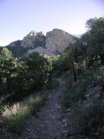
After reaching the Ridgetop there's still some climbing to do. But there's also some interesting sights to keep your mind preoccupied.
"Ridgetop" is a great place to stop for a breather. The view back into the Basin is
beautiful. At this point you're pretty close to the elevation of the South Rim. There's
a little bit of climbing left to be done, but the hardest part is over.
The "Blue Creek Lookout" waypoint indicates the location of a magnificent view down a canyon
draining away from the Chisos Mountains. Several years ago a man-made fire swept through the
valley. Although the area appears to now be healthy again, it still has not returned to
its original state prior to the fire. As always, you should be extremely cautious about
fire in the outdoors, particularly in dryer areas.
The trail will pass by several camp sites along the way. Depending on the spot they may be
near chemical toilets and bear boxes. Bear boxes are located throughout the park and allow
for convenient storage of food items and keep the bears out. By avoiding the bears'
association of free food with humans the park hopes to keep human-bear confrontations from
occurring. So far the tactic appears to be working.
The first view of the South Rim that you are likely to see.
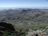
The waypoint "South Rim" marks the first appearance of the South Rim proper. The views
here are excellent and if this marks the only spot at which you can enjoy the view you'll
at least understand what all the fuss is about. You can see almost the entire southern
half of Big Bend from this spot. To the right, Santa Elena Canyon is clearly visible
cutting a slot through the mountains. That's almost 20 miles away and the limiting
factor here is the haze in the air, not the terrain.
The trail mostly follows the edge of the South Rim towards the northeast.
If the entire length of the South Rim trail is too much to tackle you can shave off a few
miles from the hike by taking the shortcut back to the start. At the waypoint marked
"Turn Right" soon after the South Rim waypoint you can instead take a left and head
straight for Boot Spring Canyon.
The trail will follow the rim and provide access to spots along the way where its possible
to peer over the edge to the cliff. Several of the spots make excellent areas for enjoying
lunch while you take in the vistas below. Just be sure to secure everything when you eat
so that it does not get blown away by the wind!
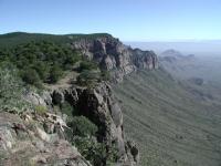
At some points along the South Rim the dropoff is so steep we got a bit nervous just reaching the camera over the edge for a shot.
Perhaps the most striking spot along the south rim is at the waypoint "Big Drop". Here
you'll find a ledge that overlooks an almost vertical drop to the desert floor below.
The drop is so steep that we were a little leery of getting too close to the edge to
admire the view. Those with real vertigo may want to keep an even safer distance from
the edge.
Soon the trail will turn to the north and then back to the west. You'll have great views
of Boot Canyon and Juniper Canyon further into the distance. The terrain here is gentle
since it follows the contour of the canyon until it runs into the creek that flows through
it.
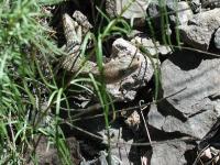
Like the rabbit before it, this Alligator Lizard did not seem too scared of people.
When the trail heads north along the creek bed the surroundings change dramatically. The
rock rises steeply along the creek's path at times and if you had to fear Mountain Lion
attacks this seems like a sure place for you. However, Mountain Lion attacks on humans
are extremely rare. You're far more likely to fall and break your leg on the trail. So,
there's no need to be too concerned. Just follow the guidelines stated on numerous park
brochures and you should be fine.
The close confines of the trail along the creek eventually open up as the canyon widens.
For some distance along the trail you can see a prominent rock spire off the east. One
of the better views are afforded at the waypoint "Spire". It should eventually become
obvious why this rock formation is called Boot Rock.
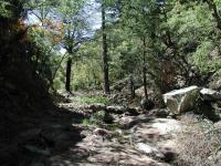
The portion of the trail that travels along the creek bed at times feels claustrophobic compared to the open vistas of the South Rim.
The South Rim Trail runs into the trail that ascends to the top of Emory Peak, the highest
point in the park. The waypoint "Emory Peak Trail" marks its location. One can hike the
South Rim Trail and also tackle Emory Peak in one day, but it's not recommended. The
additional 2 miles of the side trail is not that much. It's the additional 1,000 feet of
climbing that will really make the day seem longer.
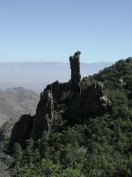
This interesting spire is called Boot Rock. Study its shape to understand why.
"Switchbacks 2" marks the point at which the trail now works its way back down to the
Basin. Like the switchbacks before it, the undulating path is designed to preserve the
trail and make the going easier. The switchbacks here seem steeper than the first ones we
encountered earlier in the day. Along the switchbacks you should be able to see the
Lodge again, a welcome sign.
After arriving at the foot of the switchbacks the rest of the trail is relatively easy,
and almost all downhill. However, the effort expended throughout the day can make this
part seem the hardest of all. Bear and Mountain Lion sightings occurred in this area of
the trail within a couple of days of our visit here. The chances of you seeing one of the
elusive creatures is small, but keep you eyes open just in case.
When you finally arrive at the Trailhead starting point you can be satisfied that you've
completed the most strenuous day hike in Big Bend and seen some of its most spectacular views.
We took things easy the next day to recuperate.