Getting there: Head west into Fredericksburg on Highway 290. In the middle of town turn right onto RR 965 and head north. After traveling approximately 18 miles look for the entrance to Enchanted Rock State Natural Area on the left.
The Park: All ages are relative. A single human's age measures up to a fraction of a sliver of the Earth's. The collective written history of Texas adds up to only a handful of generations. To measure truly significant periods of time one has to do so geologically. At 1 billion years old, Enchanted Rock provides one of the most striking examples of old to be found in Texas.
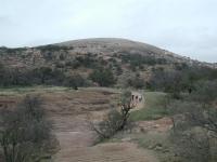
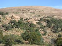
Enchanted Rock, as seen from the observation platform near the Summit Trail trailhead.
What now rises 500 feet into the air was once a bubble of liquid magma beneath the Earth. Unlike the surrounding rock that it penetrated, the consistency of this magma created a column of hard granite. Over the next 1 billion years the movement of the Earth's plates and erosion patterns of the planet's weather has chipped away at the surrounding countryside. The granite, stronger than the surrounding rock, bears the weathering better and so was exposed to the surface and slowly continues to emerge.
Looking at Little Rock to the west from Enchanted Rock. (Photo courtesy of Dave McDonald)
The geological term for such an outcrop is a batholith. Enchanted Rock is the second largest batholith in the United States, second only to the massive Stone Mountain in Georgia.
Enchanted Rock State Natural Area consists of numerous peaks, each of them a separate highpoint of the granite bubble, most of which continues to reside beneath the surface of the Earth. It's estimated that the granite bubble encompasses some 90 square miles, mostly to the north of Enchanted Rock.
When viewing Enchanted Rock from a distance, it's easy to draw a conclusion that the large masses of bare rock provide little in the way of resources for animal and plant life. However, those conclusions bely the wide abundance of life on and around Enchanted Rock, sometimes in the most unlikely of places.
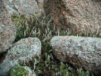
Some interesting and rare lifeforms get a foothold in some odd places at Enchanted Rock.
Upon close examination, bare rock is not bare at all. Boulders, at rest on the granite
dome, provide crevasses at their base that trap a bit of soil and provide shade, yielding a micro habitat ideal for small ferns. Long, incredibly straight cracks in the dome itself serves host to some hardier grasses. Shallow depressions on the rock surfaces collect water, which traps wind-borne soil, which again yields plant life. These mini oasises, called gnammas, even play host to fairy shrimp. Gnammas that collect enough soil to completely fill up resemble small prairies. The rock surface itself is often alive. The greenish or gray veneer of ordinarily pinkish granite is actually lichens.
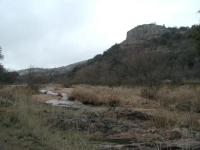
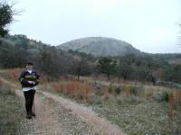
The trail to the top of Enchanted Rock is not the only picturesque path to follow in the park. Here Turkey Peak towers over Big Sandy Creek.
There are 7 miles of trails at Enchanted Rock and three separately named trails. However, there are uncounted additional paths that one can follow on the face of the peaks. The signature trail at the park is the Summit Trail, which also happens to be the most crowded. This short, but steep path leads to the summit of Enchanted Rock, approximately 500 feet above the low point of the park.
Summit Trail: The path to the summit of Enchanted Rock is the most popular trail in Enchanted Rock State Natural Area and one of the more well known hikes in the state. The trail starts at the northernmost parking area, and heads north. A restroom and water fountains are available nearby. Concrete steps make crossing Sandy Creek easy as the path leads up to the base of Enchanted Rock.
Hikers work their way toward the summit.
Enchanted Rock is a known as a
batholith - a large rounded dome of granite that formed as a pocket of magma under the surface of the Earth. Estimates place the occurrence of this formation at up to 1 billion years ago and the rock here is some of the oldest to be found in North America. Over time the surrounding limestone, a type of rock that more quickly erodes, began to weather away until the granite formation has finally begun to appear above the surface. Enchanted Rock is the second largest granite batholith in the United States, behind only
Stone Mountain in Georgia.
As the path begins to ascend the rock it picks its way around a boulder field. The rocks here started life farther up the mountain. In a process of exfoliation these layers of rock that used to form the surface of the dome broke apart and slid down the new smooth underlying layer of rock and ended up here. Keep an eye open for trail markers uphill as sometimes it is difficult to differentiate the official path from other routes.
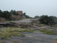
Looking down the trail from near the top. The rock looks barren here, but that's not the case elsewhere.
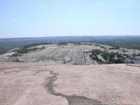
Near the waypoint "007" on the larger topo map, which is the intersection of the Echo Canyon Trail with the Summit Trail the boulder fields begin to thin out and the smooth surface of the dome begins to predominate. Large boulders that have "calved" off of the dome are still to be found on the slopes, seemingly still but actually moving in geological time downhill.
The trail on the dome is occasionally steep and can be slippery when wet. It also makes for a great stair master workout replacement. Once you've reached the smooth dome surface trail signs become moot. Just head uphill in whichever direction you prefer. A short ridge of rock provides the only obstacle. Just pick which way you'd rather go around it.
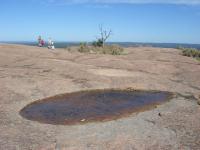
Depressions in the rock eventually host vernal pools (foreground), that eventually turn into small pockets of vegetation (background).
Near the summit you'll see more and more shallow depressions in the granite. These formations are called vernal pools. The larger ones may still contain standing water well after a rain. More interesting are the pools that over time accumulate plant debris and soil. Eventually a small plant community will take hold on a permanent basis, providing a small oasis of life on the the face of solid rock. One of the larger communities near the summit even supports a small tree.
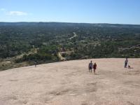
The summit is not a peak, but merely the highest point of the dome of rock. From the top the mountain slopes off gently in all directions, offering 360 degree views of the surrounding terrain. The winds can be gusty at the top and it certainly was when I visited. Even with a chin strap I ended up stowing my hat in my backpack to keep it from flapping about and being ripped from my head.
If the weather's nice people will tend to congregate at the top. Because there's no single peak to serve as a choke point, it's possible to work your way around the perimeter of the top of the dome to find a spot far enough away from everyone else to find some peace, have lunch or take a nap.
The trail backtracks to the trailhead to complete the journey. Though solitude is not a feature of the Summit Trail it does provide a nice climbing workout and great views from the top of the mountain. No wonder it's one of the best known hikes in Texas.
The Loop Trail meanders around the peaks at Enchanted Rock, but there are ample opportunities for scrambling around rocks along the trail.
Though the Loop Trail is the longest trail in the park, it is also probably the easiest trail at Enchanted Rock, terrain wise. To complete the loop you'll log 4 miles, but the path is largely flat and typically easy to navigate, with a few exceptions.
Our hike began at the southernmost parking area in the park. The trail here, as through most of the hike, consists of crushed granite and is quite wide. Part of the trail follows old jeep trails from the land's ranching days and the wider stretches of the trail are occasionally patrolled by rangers in a truck.
-small.jpg)
A view along the trail. At the two large boulders a side trail leads to an overlook to the north.
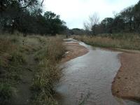
As the trail heads west it runs along the flood plain of the Sandy Creek.
The park's rocky nature really makes itself apparent as the trail turns to the north.
Unlike most of the rock one sees in the Hill Country, this rock is pink. Enchanted Rock
and most of the formations here are made up of granite. The rock erodes more slowly than limestone and as it does it tends to wear more smoothly. At the first rock outcropping of the trail we had to step carefully to maintain traction on the rock due to mist that permeated the air and coated the rock, making for slippery surfaces.
Many of the rocks found along the trail resemble mushrooms, with wide tops. The shape of these rocks is due to the pattern of erosion, typically freeze-thaw weathering. At the waypoint "Window" one can see a different result of erosion. A rock here has a hole bored straight through it.
There are a couple of side trails encountered on the hike, many of which are not official. One official trail veers off of the mail loop opposite two huge boulders. The short spur heads north to the waypoint "Overlook", which normally provides a panoramic view of the area. Due to the overcast day of our visit there was not much to see, however.
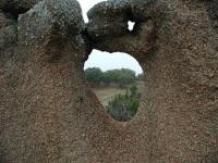
Erosion on this rock has taken a bit of a twist. A window has formed through it.
Being a State Natural Area, one might expect to see lots of animals at Enchanted Rock. Indeed there are a lot present. On the trail we observed a large number of birds, including Robins, Doves, Tit Mice, Woodpeckers and several varieties of Sparrows. We wished we had brought our binoculars to get a better look at some of the flocks. The open nature of the vegetation means the birds typically keep a wide berth of people.
Coppertone on the Loop Trail with Enchanted Rock in the background. This photo shows both the exfoliation of Enchanted Rock and a little part of the quartz explosion at Coppertone's feet.
The trail section between Moss Lake and the turn toward Freshman Mountain is actually not too terribly interesting, compared to some of the rock formations encountered thus far and soon to be encountered. Why bother coming this way? Why not just turn down Echo Canyon, where the terrain is more varied and entertaining? Because you never know what you'll find around the bend.
With Freshman Mountain and Buzzard's Roost rising before us we saw what from a distance
appeared to be trash on the trail. What resembled shredded newspaper from afar was actually an explosion of quartz. From a little mound above the trail, a vein of quartz had weathered away and broken into pieces that littered the path with nuggets of all sizes and scattered them downhill and into a creek bed.
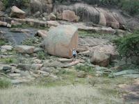
Austin Explorer next to some of the large boulders that have exfoliated from Buzzard's Roost.
Still excited from the quartz explosion, we followed the trail as it bisected Buzzard's
Roost and Freshman Mountain. To the right, Freshman Mountain presented some sheer rock
walls that a few rock climbers challenged. To the left, the more gentle slope of Buzzard's Roost deposited huge boulders at the base of the hill, perfect for rock climbing of a more tame sort. We spotted a fox squirrel near a running stream here. Though not tame, he did not seem too disturbed by our close proximity. All things considered, this may be our favorite spot along the hike.
The Loop Trail running along the banks of Big Sandy Creek.
Due to recent heavy rains crossing Big Sandy Creek was harder than normal, though still not too difficult. Once on the opposite side of the creek the trail heads south and follows the creek's edge. For the first time on the hike the trail surface here includes some packed dirt.
After passing the group shelter we happened upon a White Tailed Deer crossing the creek to put some distance between herself and us. Only after watching the deer disappear over a ridge did we turn around and notice three more deer, just a short distance behind us. Once they saw our attention focused on them they also vacated the area.
The Loop Trail officially crosses the creek again before intersecting with the Summit
Trail and running into the northernmost parking area in the park. We missed that crossing though, perhaps due in large part to the higher waters in the creek. Instead, we continued to follow a marked trail on the eastern side of the creek until it ran into the opposite side of the long the parking lot from our trailhead. Not counting the traverse across the parking lot at the end of the day we covered 4.5 miles in a slightly modified loop around the mountains.