Getting there: From Austin head south on Highway 183. Proceed through Luling and turn right onto Park Road 11 south of town. The park ranger station is two miles down the road on the edge of the town of Ottine. To get to the trailhead for the Hiking Trail continue down Park Road 11 and turn left after crossing the third bridge. Park near the Rectory building and head east on the road for a short distance looking for the trailhead on the right side of the road.
The Hike: Unlike the nearby River Trail and
Palmetto Trail the Hiking Trail does not provide an interpretive guide. That allows for one to concentrate on their hiking and letting their mind wander as they stroll through the forest.
-small.jpg)
A view along the well shaded trail. Note the few Palmettos to the right.
The trail begins at the waypoint "Trailhead" on the map. Not long after starting, in fact too short a distance to include another waypoint on the map, lies an interesting little sight along the trail. We can't tell you exactly what it is since that would give away the answer to the
Palmetto Tired Trees geocache, one of two in the park during our visit.
After a couple of turns in the trail a sign to the left indicates the presense of a Mud Boil. Yet, what appears here instead looks at best to be a vegetation rich depression in the ground. This is one example of the changing landscape in the area. Not that long ago this area was wetter and more geothermally active. Artesian springs dotted the landscape and hot springs and other formations created mud boils like the one that used to be here. The activity stopped in the 1970's, probably due to the changes brought about by the wide spread drilling for both oil and water in the area.
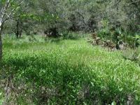
Now a perfect spot for these moisture loving plants, this natural bowl used to contain boiling mud.
At about .2 miles into the hike the trail splits into a Y at the waypoint "Y-Left". We proceeded to the left to complete the loop of the trail in a clockwise manner. Either choice should suffice on this trail.
Much of the trail is well covered by trees, which are predominately Elms and Hackberries here. Though fewer in number here than on the Palmetto Trail, there are numerous Palmettos in this area of the park also.
The surface of the trail is dirt with a few sandy spots. Like the rest of the park, there is almost no elevation change, which makes for an easy hike.
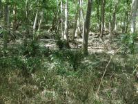
These natural depressions in the terrain retain moisture even after the standing water evaporates away. It's terrain like this that the Palmettos love.
Palmetto State Park displays a number of signs warning people about the presence of snakes. The only snake that we observed on our three hikes in the park was on the Hiking Trail. The snake was some distance away from us on the opposite side of a small temporary pond. Startled by our presence, the snake froze for a few minutes until it finally slithered off behind a tree. While being on the lookout for snakes is always a good idea, there's no reason to allow the fact that snakes find the park a great place to live spoil your visit.
The trail completes a loop, returns to the Y and then retraces a path back to the trailhead. We found the trail to be just shy of 1 mile and we completed the hike in 38 minutes. Without an interpretive trail guide we were able to complete the longest hike in the park as fast as, if not quicker, than the others.